• A friendly and periodic reminder of the rules we use for fostering high SNR and quality conversation and interaction at Stormtrack: Forum rules

    P.S. - Nothing specific happened to prompt this message! No one is in trouble, there are no flame wars in effect, nor any inappropriate conversation ongoing. This is being posted sitewide as a casual refresher.

5/22/10 DISC: SD

Wow, the transmission tower being sheared from the concrete base and tossed 500 yards down the field should tell you this was a very violent tornado. Also noting that trees were debarked, I wouldn't be surprised if this one comes out EF4.
 
Wow, the transmission tower being sheared from the concrete base and tossed 500 yards down the field should tell you this was a very violent tornado. Also noting that trees were debarked, I wouldn't be surprised if this one comes out EF4.

Yeah, that does seem really impressive with the transmission tower but I dont know if that is enough to warrant an EF4 rating.
 
I don't think there are any DoD's designated for actually launching a Transmission tower a third of a mile through the air, only for toppling them and that doesn't reach EF4 intensity, but I don't know how much leeway they have with these storms. Had hit hit enough structures of decent build, it certainly looked capable of doing EF4+ damage but that isn't what counts!
 
I'm not surprised that its an EF4. Even watching the streaming video you could tell it was EF4 material. The resolution was bad on the streaming video, but whenever you see the outer skirt/scud clouds rotating around the tornado as fast as they were with that wedge you know its a very strong tornado. That wedge was a beast.
 
I am a little bit surprised they could rate a tornado an EF4 based on the evidence but again I am not an expert. Some of the damage does seem impressive although. It very well may have been an EF5 had it have hit a town with well-built structures.
 
Last time there was a F4 tornado in South Dakota, was June 24, 2003
(Manchester Tornado) Kingsbury County, until the May 22, 2010 EF-4 Tornado.
 
Good day all,

Does anyone have any images (or links to them) of the GRLevel Analyst (volumetric) images of the storm near Bowdle (from Aberdeen's radar data)?
 
This was my first experience (up close and personal) with the EF4 wedge tornado as it grazed the north side of Bowdle, SD. What struck me most were the intense winds that were rushing into the storm. I actually had to take a wide stance as the winds that were behind me wanted to knock me off balance. I don't know if anyone else noticed this, but it really stood out in my mind and I will never forget that experience.
 
Good day all,

This was my first experience (up close and personal) with the EF4 wedge tornado as it grazed the north side of Bowdle, SD. What struck me most were the intense winds that were rushing into the storm. I actually had to take a wide stance as the winds that were behind me wanted to knock me off balance. I don't know if anyone else noticed this, but it really stood out in my mind and I will never forget that experience.

That experience alone was unreal. The raw "horsepower" of that (the vacuum effect) was insane.

This tornado during its high-point had a very wide and expansive envelope of inflow / inflow-jets at over 50-60 Knots ... This was within a mile of the tornado core-flow (get into that, and you would be in big trouble).

The inflow winds nearly ripped my car door right off, I could not open / hold onto the door, and it bent the hinges. And this was with the tornado still intensifying (on Highway 2 SW of Bowdle).

I posted amazing video of the event below...

http://www.youtube.com/watch?v=1OpxZkrd4oA

Second, the RFD associated with the tornado / backside was gusting around 100 MPH at my location north of Bowdle, with side-ways DRC precipitation.

Yes, me too ... Won't forget this "tickle" by the hand of God for some time.

It's fortunate a town did not take a direct hit from the wedge.
 
I went through my video and pictures trying to get an accurate tornado count for the day. While on the chase I was thinking there were two main tornadoes that I witnessed, believing that the first several tornadoes were sub vortices of the developing wedge. I revised the count to four after seeing that, although these tornadoes were part of a larger circulation, the larger circulation had not yet become tornadic (visible debris). After pouring through my pictures and video, I may have actually witnessed six separate tornadoes. We left the storm early as the storm was permanently transitioning into an HP mode, making it tricky to chase, and we wanted to go back and get Kevin Crawmer's car which he ditched south of Bowdle. There were several more tornadoes after this including that rope with the drillbit end, which we missed as a result.
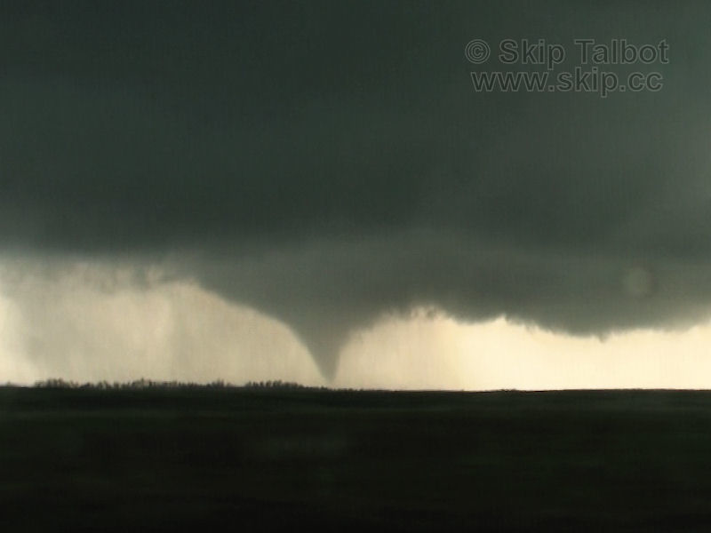
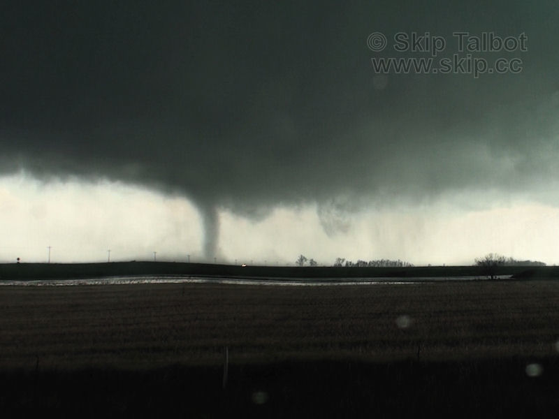
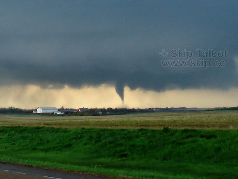
Tornado #1:
Touched down at 6:15 and lasted approximately 4-5 minutes
100522vid01.jpg

100522vid02.jpg

The initial tornado fully condensed quickly and maintained mostly a cone shape. The funnel orbited around the meso/wall cloud/tornado cyclone, winding up on the north side of it before it dissipated. As a side note, our intercept of these initial tornadoes was quite unorthodox. We drove north underneath the RFD and could see right up in the vaulted region it created in the storm, and then we drove east, right underneath the new wall cloud. I distinctly remember coming up from behind the wall cloud which had a very prominent tail cloud and well developed base, while our tornado formed out of what looked like the occluding horseshoe base of the old wall cloud.
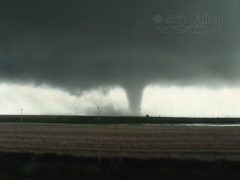
Tornado #2:
Approximately 6:19
100522vid03.jpg

10052219.jpg

When I was going through my pictures I thought that this was just a funnel and that the debris cloud in the second shot was remnants of the first tornado. Its even stated this way in my log, which I need to revise. There are two funnels in the first shot. They are more than likely sub vortices of a larger circulation, however, I don't believe that the larger circulation had intensified to the point that it was tornadic during this time. So while these tornadoes orbit a larger circulation, they are independent. In the first shot, tornado #1 is on the north/closer end of the photo and the second funnel is developing tornado #2. Tornado #2 does not fully condense, but does have a visible debris cloud as seen in the second shot. This tornado also orbited around the meso winding up on the north side.
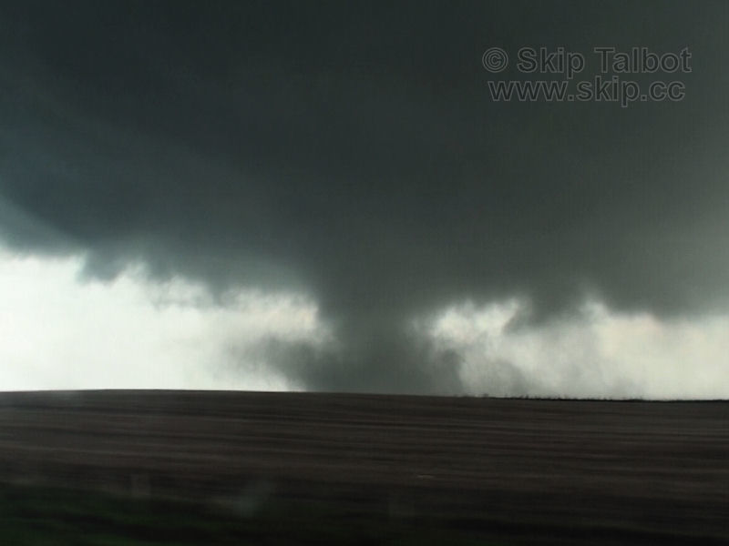
Tornado #3:
6:20 to approximately 6:22
100522vid04.jpg

100522vid05.jpg

100522vid06.jpg

This tornado condensed so rapidly, that it looked exactly like a sub vort on a developing wedge, which is what I immediately though of when I saw it. The transition between this tornado and the wedge is fuzzier as the debris cloud on this tornado fanned out and eventually the wedge condensed over that. I'd still argue though at this point that this tornado went through a full cycle before the wedge had really formed, or that the wedge was starting to develop while this tornado was still dissipating.
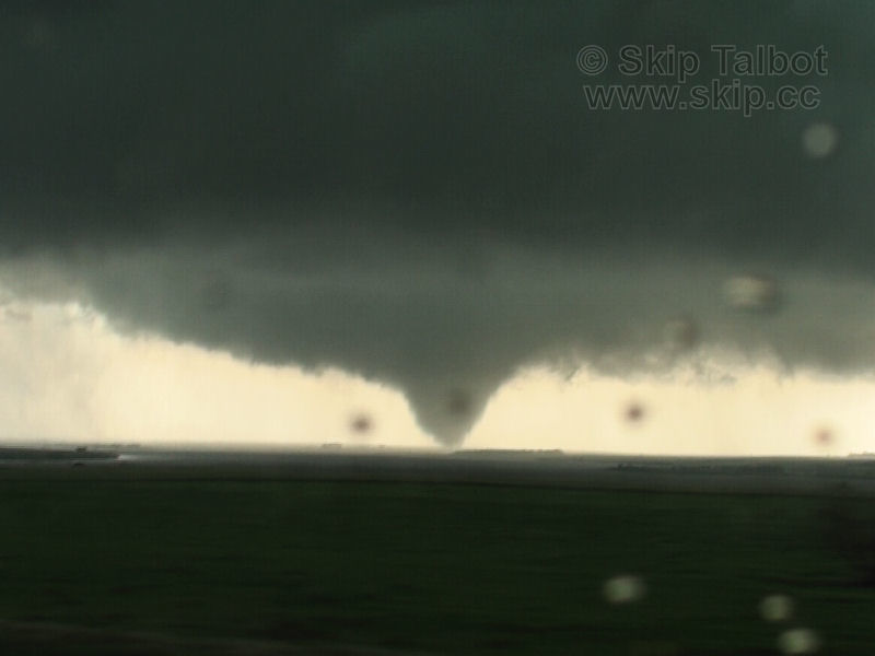
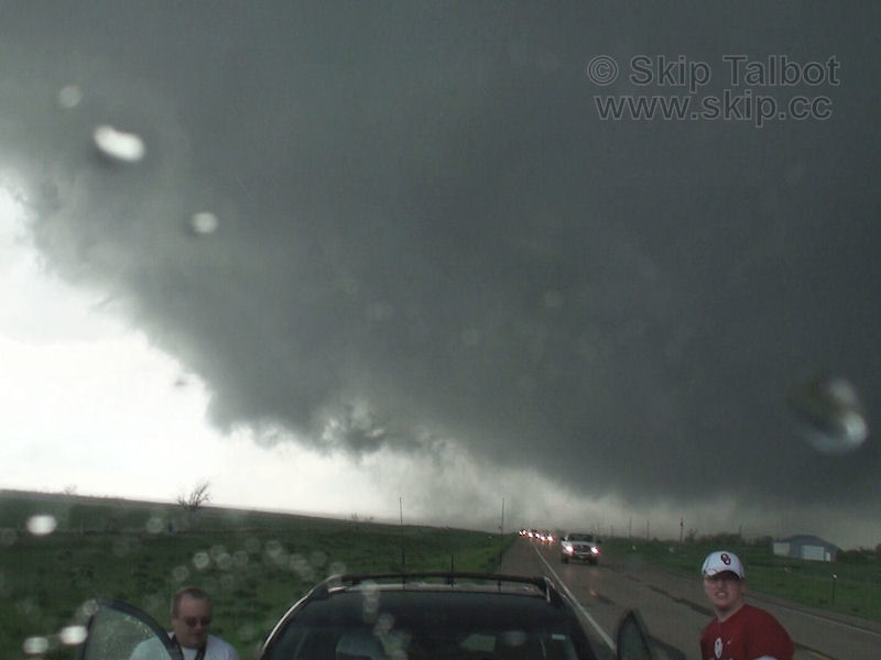
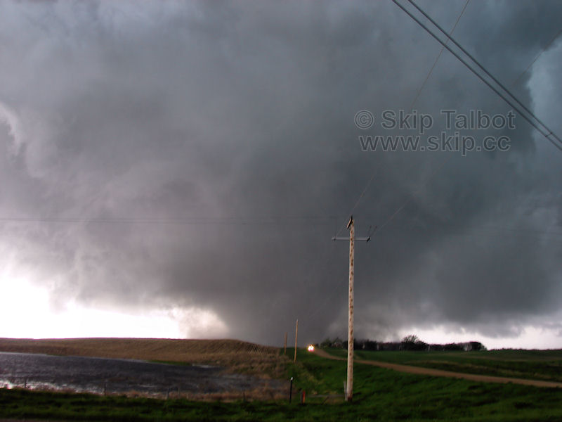
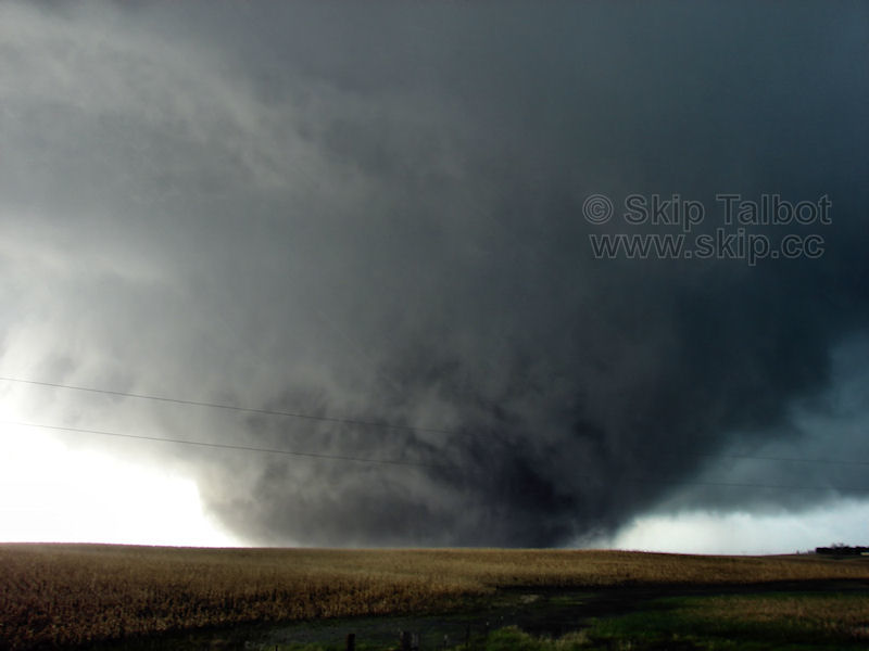
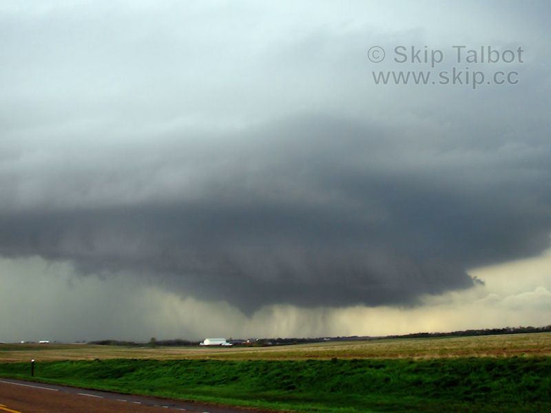
Tornado #4:
6:22 (broad dust whirl) to 6:39 (still in progress but lost sight due to repositioning and heavy RFD rain wrapping)
100522vid07.jpg

10052220.jpg

10052222.jpg

10052224.jpg

The wedge formed from a large, yet diffuse dusty debris cloud beneath a wildly rotating meso. If you watch my video there is full condensation on the back end of the dust plume that lasts mere seconds. I'd definitely say this was a sub vortex of the wedge at this point as the dust on the ground encompassing it was clearly tornadic. the wedge fully condenses as we're driving north on the west side of Bowdle and is well in progress as we cut through town. We make our turn north out of Bowdle noting the fully condensed tornado, letting it approach our position before we ducked south to avoid the RFD core and ditch Kevin's smoking car.
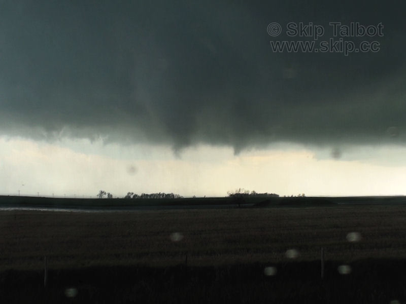
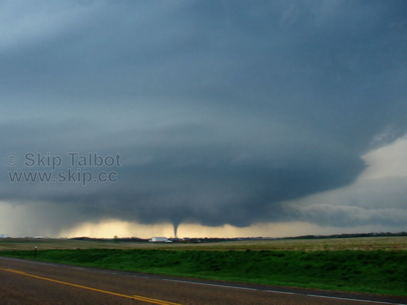
Tornado #5:
6:50 to 6:54
10052225.jpg

10052226.jpg

10052227.jpg

Clearly a separate tornado from the first batch. Tornado #5 formed after the storm transitioned from HP to classic modes. This transition is relatively rare, and the fact that we saw this several times that day is just epic and a tribute to the power of this storm. The tornado retreated before fully condensing again with more of a visible debris cloud. I don't doubt there was one ground circulation and a single funnel associated with both of these periods of condensation, however.
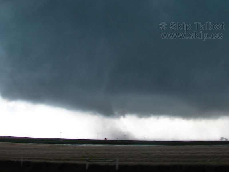
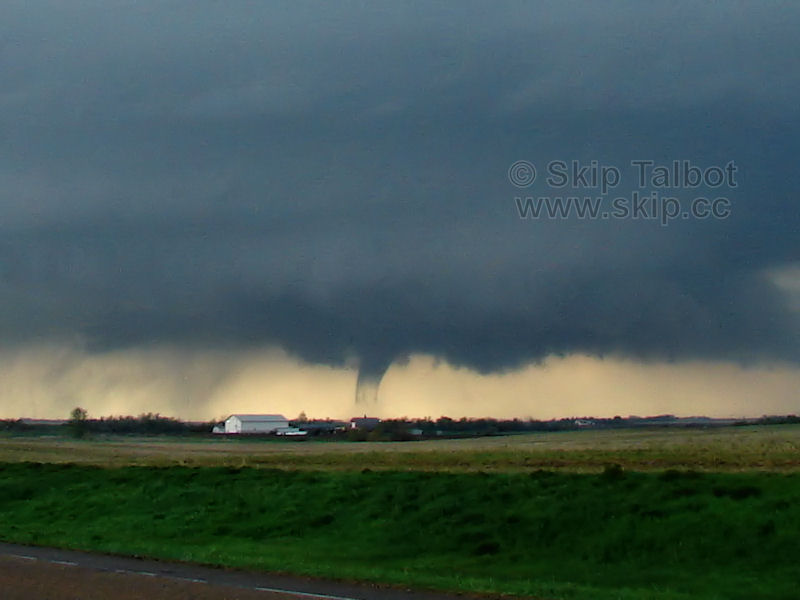
Tornado #6:
Approximately 7:00
10052228.jpg

This one is not as clear cut. Its most likely a funnel from our vantage point. Other chaser footage from closer vantage points confirms there is a debris cloud underneath this feature, however. Its possible this is a continuation of tornado #5, however, I have several minutes in between my video between the two and I believe tornado #5 had fully retreated before this feature appeared. I did lose my fix on the storm for a couple minutes when I bumped my pan/tilt controls, so I don't really have the transition on video. Our position makes confirming this feature as tornadic difficult, but the other chaser footage sells it for me.

No doubt there were a lot more tornadoes than I actually got shots of. Radar animation with GPS overlay coming next...
 
Last edited by a moderator:
Amazing day. I was reviewing my footage and basically agree with Skip about the number of tornadoes. As the meso and developing tornado approached 12, I was rushing to get out from under it by heading east on 12. I almost didn't make it. Detailed report with times, images, video and data here:

http://www.harkphoto.com/05222010.html

I did see early in the chase, a possible tornado to the northwest on a different meso but by the main storm. From approximately 6:03 to 6:05PM, I saw a very interesting lowering after I left the town of Lowry. It was to the northwest. Due to my motion and distance, it is hard to judge rotation and ground contact.

Image taken at 6:03 PM; view to northwest:
http://www.harkphoto.com/052210weirdlowering1806vcap.jpg

I never got a chance to look at radar at that point as I was on visual mode and starting to get interested in the lowering to the south that would become the first tornado on the main Bowdle storm. I am curious if anybody got a better look at that feature.


This was one of my wildest chase experiences. I also got soem great video of the falling transmission tower north of Bowdle (see report link above). I wish I had stayed closer that evening and looked at the damage.

Bill Hark
 
I went through my video and pictures trying to get an accurate tornado count for the day. While on the chase I was thinking there were two main tornadoes that I witnessed, believing that the first several tornadoes were sub vortices of the developing wedge.

I think you had it right originally.

Most any tornado counting really does end up getting into splitting hairs. One either takes the approach for more tornadoes or the approach for less tornadoes. All thanks to the lowest couple thousand feet(or worse yet lol).

Many of the longer lived/significant tornadoes out there really seem to like a 30-35 minute lifespan. Like for whatever reason, it seems once something goes for a while, that is about what it will go for from beginning to end. I think everything from the start through the wedge is doing just that(and falls into that time length). Sub vorts under one continually growing tornado cyclone aloft. Seems the easiest way to classify those through the wedge roping out.

Having some set number, I've never understood what that gets anyone. Other than state tornado stats, whatever those are even worth.

Just one storm can prove how pointless numbers are. No matter how one defines any of it(not that they could even see all they'd need to then anyway)...the same process you viewed is what happened. Some number later just seems completely useless as a chaser. I don't even like bothering as much as I am now with this one lol.

I mean if one has a big area with vortices touching down, going across and lifting, repeatedly in quick fashion, one isn't going and counting each of those as tornadoes, right? Like say that Grand Isalnd video at night from way back, or others. I'd say the same thing was happening on SD just slower fashion, up through the wedge. Seems far less complicated to just think of that as one tornado and be content. Because really, there has to be hair splitting, that is for sure. Seems most logical to take the least so version and figure that was one growing tornado cyclone.

Not that it would then get any less complicated after that lol and the much wider area producing tornadoes. At least with those first ones, there really was one long lived very focused common center. Likely one tornado cyclone.
 
Last edited by a moderator:
Good day all,

I also noticed a (possible) additional tornado that may be added. This was while the storm was just west of Bowdle, SD by a few miles, and crossing Highway 12 after 6:15 (around 6:23 to be exact).

bcpn0522.jpg


Above: Annotated diagram, grabbed from 4 video frames near 3:46 in the video, and put into a panorama and enhanced, a possible (satellite?) tornado can easily be seen to my NW. I had an idea this feature was there while filming (at the corner of my eye) but saw it in greater detail when I reviewed the video.

Note: In the video of this event, the link is repeated below, the composite (panorama) was grabbed from the HD frames near 3:46 in the video, where the pan from SE to NW shows the possible satellite / old meso / tornado. The directions are also annotated as well. This is also the same time the storm was "cycling" between the stove pipe / barrel tornado south of Highway 12 and the violent wedge that struck the northern fringes of Bowdle at about 6:30 PM and after.

http://www.youtube.com/watch?v=1OpxZkrd4oA

This is why we always keep our heads on a swivel in such violent storms rather than focusing on the main "event" (tornado).
 
Last edited by a moderator:
That must have come off the split that could be seen nw of the storm just prior to tornadogenisis. I sure never saw that or noticed at the time, but clearly recall the other base up in there well before that, which I think looked like a split on radar.

Edit: Heck it may not be the earlier split the more I think about timing and look at that.
 
Last edited by a moderator:
I'm sure it is unarguable that the radar data of this storm was incredible. One thing I noticed after I looked at archived level 2 data was the donut hole present during one of the later tornadoes. This was during the long-track EF-2 that crossed from Edmunds into McPherson County at around 0110 UTC. I made an animated gif showing this. The amazing thing is that I was able to use consecutive elevation scans, which were 14 to 18 seconds apart, to see the rotational motion in just the reflectivity. It's simply stunning!

01:13:54 UTC from KABR from 0.5 to 1.4 deg.

By the way, during that volume scan, I was able to find the following values:

0.5 deg. max G2G shear: 125.30 kts
0.5 deg. max delta-v: 165.12 kts
0.9 deg. max G2G shear: 126.27 kts
0.9 deg. max delta-v: 182.61 kts
1.4 deg. max G2G shear: 169.00 kts
1.4 deg. max delta-v: 173.86 kts

Also, the circulation was apparently large enough at 0.5 and 0.9 degrees that the azimuth of bins between the two that had the maximum delta-v had lower velocities suggesting that azimuth may have been in the middle of the circulation.
 
Last edited by a moderator:
http://www.crh.noaa.gov/images/abr/animation/Bowdle_Z.gif

Nice long loop there too. Amazing just how far right it turns right at and after Bowdle which you can see listed on there.

That's incredible to see a loop that long. I remember thinking during the first tornado that I was going to have trouble catching up as I was filming it from behind, but after turning right and slowing down significantly, I had no problems getting right up next to the Bowdle tornado. It's amazing the difference in speed between the first tornado - which is obviously moving much faster as it moved from far right to far left in my video screen in less than a minute, and the Bowdle tornado which was creeping along at maybe 10 mph.
 
That's incredible to see a loop that long. I remember thinking during the first tornado that I was going to have trouble catching up as I was filming it from behind, but after turning right and slowing down significantly, I had no problems getting right up next to the Bowdle tornado. It's amazing the difference in speed between the first tornado - which is obviously moving much faster as it moved from far right to far left in my video screen in less than a minute, and the Bowdle tornado which was creeping along at maybe 10 mph.


Yeah I remember thinking it was all still moving along at least decently as I pulled over north of Bowdle. I got delayed a bit after the close intercept west of Bowdle as the whole inside of my windshield was covered in water, as was my vid cam and still camera...and had to get them all wiped off. When I turned and went north of Bowdle it wasn't too far west of the highway yet and I thought, I'll just stop where I did cause it will be to my north soon anyway. It seemed like it was right there west of that highway out of Bowdle that it truly slowed down to essentially not going anywhere. Up through that whole time I kept thinking, this thing is moving along decently. Then it was like, this thing is never going to cross the highway north of Bowdle.
 
One other interesting aspect of this storm was the 700 mb temperature. It was 12 deg C. at 0Z per SPC.

http://www.spc.noaa.gov/exper/archive/events/100522/index.html

EF4 tornadoes rarely occur at 700 temps above 12.

Per Matthew Bunkers, John R. Wetenkamp and Jeffrey J.Schield
article ( Out of the NWS Rapid City, SD office)

Observations of the Relationship between 700-mb Temperatures and Severe Weather Reports across the Contiguous United States

http://www.crh.noaa.gov/images/unr/soo/700mb/Bunkers-Wetenkamp-Schild_2009_WAF_ver1.pdf

In fact, during the study period between 1993 to 2006..there was no F4 or F5 reports with 700 temps above 12. Taking it one step further, less than 5% of all the tornadoes in the country occurred with 700 temps above 12.

In this scenario, with the temps right at 12; clearly this storm had something extra going for it to make it happen.

With dewpoints of at least 75 under the initial updraft that I measured, the convergence at the triple point, and great venting of the updraft that was apparant per later SAT pics I'm sure all had a part in this.
 
Back
Top