3/9/06 FCST: Mid- and Lower-Mississippi River Valley

Tony Lyza

EF3
Joined
Jan 13, 2006
Messages
240
Location
Schererville, IN
Thursday appears to be evolving into a nastier situation with each model run. I have grave concerns for the Mississippi Valley.

The 1800z GFS showed a powerful sfc low at the following positions:

36hr (0600z Thursday): 992 mb wrn OK
42hr (1200z Thursday): 900mb IA/MO/IL intersection
48hr (1800z Thursday): 984mb ern MO
54hr (0000z Friday): 980mb nw IL
60hr (0600z Friday): 977mb wrn Lake Michigan

The 1800z GFS also shows LI's of up to -3.60, especially in Mississippi.


As for the 1800z ETA, it has the sfc low progged at the following locations:

36hr (0600z Thursday): not formed
42hr (1200z Thursday): beginning to form over the Red River
48hr (1800z Thursday): 989mb over nw Arkansas
54hr (0000z Friday): 987mb over St. Louis
60hr (0600z Friday): 986mb over ctl IL

The ETA shows a tongue of 1500-2000 J/kg SBCAPE all the way up to the southern suburbs of St. Louis, with 500 J/kg SBCAPE numbers all the way up to Springfield. MLCAPE numbers of up to 200 J/kg stream north to the Missouri Bootheel, with 1500 J/kg MLCAPE up to St. Louis. A slight inversion is forecast to be in place over this area, with CIHN of up to -40 indicated. Dew points of 60-65°F are indicated to spread up to srn IL, with the ETA showing LIs of up to -6. All this, along with a LLJ of up to 75kt, a 700mb system of up to 77kt, a 500mb system of up to 95kt, and a 250mb jet stream disturbance of up to 110kt in Mississippi. The 0-3km helicity of up to 500 m**2/s**2 would probably yield a 0-3km EHI of up to ~4.5-5. Though a severe squall line will likely be in place that morning, these numbers should yield addtional development of storms ahead of the squall line. It is my belief that these will be intense supercells, with the possibility of strong/violent tornadoes. I also would not be surprised if a couple of cells broke off the squall line to become supercells a la the Evansville tornado.

I leave you with this quote from Tim Roche, professional meteorologist with the Weather Underground:

As the sun angle starts to rise in March and April, the ground begins to warm up a lot faster than the upper atmosphere. This creates instability, and is one of the major reasons that springtime is severe weather season in the Mid-West. Instability isn't the only factor in severe thunderstorms you need a bunch of factors coming together.

These factors look like they might begin to converge over the southern Mississippi Valley on Thursday afternoon. Moist southerly flow ahead of the system will substantially moisten the Atmosphere, while a strong shortwave trof moves into the target region. This combination of events, coupled with the extra instability caused by the sun warming the low layers of the atmosphere could spell disaster for those living in the area.
 
Thursday looks pretty volatile, indeed. The only caveats that I see (at a glance) is the weak capping inversion and the relatively low magnitude of the BL moisture. It looks like there will be convective mayhem on Thursday, so it's going to be real tough trying to get insolation to develop and it will also be difficult for the cells to remain discrete. However, should a stronger cap be present (and perhaps a nice dry slot aloft), I believe that Thursday holds good potential for significant tornadoes. Tds are less than what one would want to see in a potential big day in the Southeast, but the *strong* shear might be able to compensate.

Also, it is interesting to note that the models are forecasting a coupled jet to develop over the area of interest. This should enhance the surface low via ageostrophic divergence aloft. This in turn would cause the winds to back at the surface, creating even stronger directional shear.

Overall, I think the tornado threat is fairly high *if* any storms can remain discrete. We shall see.

Gabe
 
Thursday is really starting to look like a potentially significant severe weather outbreak with violent tornadoes. Right now NAM and GFS solutions differ on both the timing and position of the intense shortwave to eject out of the southern plains early on Thursday. But both generally agree on a strong, north-south oriented front/dryline associated with a surface low rapidly accerating northeastward. Shear looks off the charts, moisture will be fine and give the cold temps aloft instability will be supportive of supercells. Of course with such intense forcing there's always risk of linear development.

But with the incredible shear the models are forecasting with a north-south oriented boundary, a broken line of supercells or even one or two discrete storms seems quite possible before full development into an intense squall line later on. It will be very interesting to see which model has the better handle on the exact timing and position of this particular shortwave. Based only on the NAM it appears Louisiana may need to test out their tornado sirens.
 
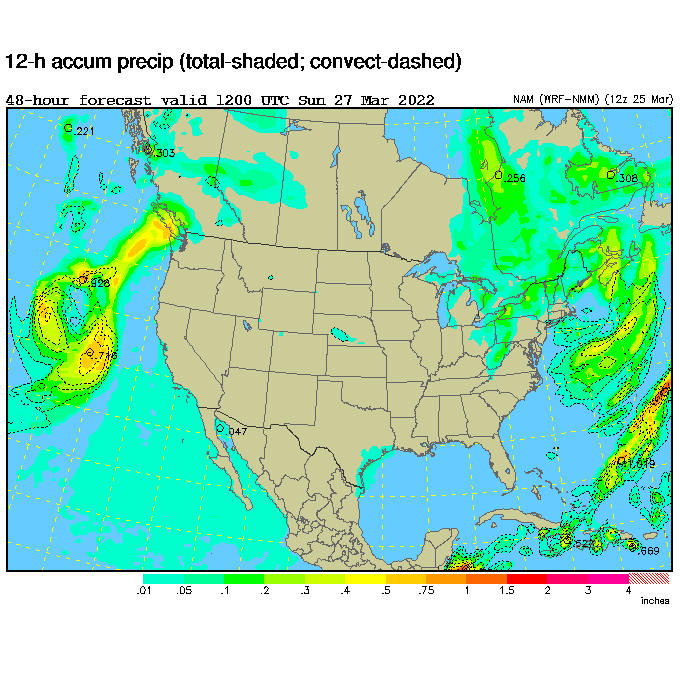
Have I gone nuts, or has the ETA (yeah, I know it's now NAM) painted a seperate line of storms (supercells?) ahead of the main squall line?:

eta48hr_sfc_prcp.gif
 
Actually per NAM 0z run tonight northeast Tx like DFW and area east of there may have an intense time of it between 12z and 18z. Stay tuned for more later.

Edit: Actually it is probably starting a bit east of DFW so they may miss unless shortwave speeds up. Paris, Tx may be under the gun though.

Looks to me during the day the area along the LA/AR border will be under the gun - that and southern AR. After dark...further east. I'll have to take a look at that.
 
This excerpt from the Jackson, Mississippi, AFD really seems to support my thinking for this outbreak (not to mention it is a bit scary):

ON THURSDAY INTENSE UPPER TROUGH WILL BECOME NEGATIVELY TILED AS IT
PUSHES THROUGH THE PLAINS. THIS WILL PUSH IN SOME IMPRESSIVE
INSTABILITY INDICES. AS FAR AS JET DYNAMICS WILL BE CONCERN
(COUPLING OF 130-40 KNOT 200 MB JETS...90-100KT 500 MB JETS...60-70
KT 850 JET)...STRONG DRY PUNCH...ENERGY HELICITY INDEXES
4-6...DEWPOINTS IN THE LOWER 60S...CRAVEN TORNADO PARAMETER
2-4.0...LAYER SIGNIFICANT WEATHER AROUND 20000...CAPE
1500-2000...0-1 KM BULK SHEAR 40 KNOTS...0-6KM BULK SHEAR 60-70
KNOTS...SHOWWALTER INDEX -2 TO -4. STORM MOTION WILL BE GENERALLY
FROM 240 AT 60-70 KNOTS. THIS SPELLS GOOD WIND SHEAR FOR POSSIBLE
TORNADOES AS WELL AS SOME STRAIGHT LINE WINDS ALONG THE SQUALL LINE.
THE BEST CHANCE OF SEVERE AT THIS TIME LOOKS TO BE ON THE SOUTHERN
TIER OF THE FORECAST AREA...WHERE DYNAMICS WILL BE THE BEST. THE BAD
THING OF ABOUT THIS IS THAT IT WILL COME THROUGH THE REGION DURING
THE HEAT OF DAY ON THURSDAY. CHECKING MODEL SOUNDINGS THE NAM DOES
NOT HAVE MUCH OF A CAP...WHILE THE GFS HAS A STRONG CAP ON THURSDAY
MORNING...WHICH WILL BE HARDER TO BREAK DURING THE DAY. SO WITH THIS
SYSTEM EXPECT SHALLOW SUPERCELLS TO MOVE RAPIDLY NORTHEAST AHEAD OF
AN APPROACHING SQUALL LINE. WINDS ACROSS THE AREA WILL BE
STRONG...STILL LOOKING AT MEETING WIND ADVISORY CRITERIA CWA
WIDE...ESPECIALLY WITH 60 KNOTS AT THE 925 MB LEVEL. SO WILL HAVE 30
MPH GUSTING TO 40 MPH...ESPECIALLY IN THE DELTA REGION.
 
This day really looks like it has potiental. It's nice to see that the NAM shows the sfc low not so far north. This is more in line with what the ECMWF was predicting several days ago, which is much more prefered than having the sfc low in MI by 0z. At 21z surface low is in N AR with very high 0-3km Cape values and 60kts bulk shear across a large area. With an ongoing convective cluster expected to move into the region it's pretty hard to nail down a particular region right now. LCL's across the region are quite low (generally 800) with a nice 70kt LLJ. Of course there isn't much for directional shear but there is plenty of speed shear. Mississippi seems to be best juxtaposed with 200 j/kg 0-3km CAPE and 400-500 m2/s2 0-3km SRH which would suggest the possibility of strong tornadoes.

It's a little early to nail down a particular target, espically with the widespread nature of convection. It would appear attm that the highest chance for tornadoes would be in E LA/ E AR and most of MS. Seems like cloud cover could hamper instability, espically for the northern portions.
 
Using 03/08 00Z NAM 42hr output valid 03/09 18Z and 48hr output valid 03/10 00Z:

I'm gonna go with a target near El Dorado, AR for possible mid afternoon tornadic supercells. NAM has the shortwave and associated fronts
moving fairly quickly across LA/AR during the afternnon, with the cold front progged to be approaching the MS border by 00Z. HWY 82 east
looks like a good road to try and keep up with the cells as they race ne/ene at 45mph or so. Low 60s dewpoints are progged for the area
by mid afternoon, yielding CAPES 1500-2000 J/kg assuming little or no cloud cover to inhibit diurnal heating. Surface low in northwestern AR
at noon forecast to deepen to below 990mb and move ENE into southeast MO by early eve Thursday. Around noon south central AR should
be close to the western edge of the strong 60+ kt SSWly LLJ, which is where I would expect storms to fire by then if the have not already.

One thing I don't like about the NAM's current output for Thursday is the positive orientation of the 500mb trough axis, which somewhat hinders
diffluent flow at that level. However, flow at 300mb V's out nicely and upper forcing should not be a problem as 100+kt 300mb jet crosses the area.
Overall surface to stratosphere dynamics look to be a better to the northeast towards the Memphis area on up into SE MO. These areas are also
closer to the forecasted track of the surface low, which should all increase tornado potential with any cells that form or move into the region.
But I'm a sucker for instability and as of right now like a target farther southwest where moisture and temps look to be higher.

Here's a link to a cartoon diagram juxtaposing 18Z and 00Z forecasted parameters over the southern Miss. valley:

Hatched Light Green = 18Z and 00Z CAPE aoa 2000 J/kg
Hatched yellow = 18Z 60+ surface dewpoints
Solid orange = 18Z 65+ surface dewpoints
Wind barbs are surface vectors
 
I am sitting here in East MS, highly anticipating this event. I wont have to go far if I do go out. I will probably head out west of 82 and get into the Delta of MS and chase it back to the east.

I do have a few concerns about the event though. I am afraid this thing could go linearly pretty quickly. Also, I am concerned that we wake up Thurs. morning and be socked in with cloud cover.
 
I am very surprised at the lack of the moderate risk for tomorrow...as of yet. However, as this EXCERPT (that's right, this is an EXCERPT) from the Jackson AFD would suggest, a moderate might be expected at 1730z (bolding added for effect):

NOW FOR THE BIG SHOW! ALL MODELS CONTINUE TO SHOW EXCELLENT
AGREEMENT WITH THE TIMING AND EVOLUTION OF THE SYSTEM ON THU. DUE TO
THIS...CONFIDENCE IS QUITE HIGH IN HOW MOST THINGS WILL PLAY OUT. TO
SET THE STAGE A BIT...THIS IS LIKELY THE MOST IMPRESSIVE SPRING
SETUP...DYNAMICALLY SPEAKING...THAT I HAVE EVER SEEN! .


SPC has upgraded a good portion of the south central states to moderate risk as of 1730Z. In the discussion, they mention a potential tornado outbreak:
ALTHOUGH NOT YET CERTAIN...A TORNADO OUTBREAK WILL BE POSSIBLE
ESPECIALLY IF A LARGE NUMBER OF STORMS REMAIN DISCRETE AS THE
INITIAL LARGE CLUSTER OF STORMS DRIFTS EWD AND EXPANDS FROM NORTH TO
SOUTH ACROSS THE MS VALLEY DURING THE AFTERNOON. THE BEST POTENTIAL
FOR LONG TRACK STRONG OR VIOLENT TORNADOES SHOULD BE WHERE
INSTABILITY IS LOCALLY MAXIMIZED AND JUST AHEAD OF THE SFC LOW AND
IN THE NOSE OF THE MID-LEVEL JET. IF THE MAJORITY OF THE STORMS
REMAIN LINEAR INSTEAD OF DISCRETE...A WIDESPREAD WIND DAMAGE EVENT
WOULD BE MORE LIKELY AS A SQUALL-LINE MOVES EWD ACROSS THE REGION.
WIND GUSTS ABOVE 70 KTS AND LARGE HAIL ABOVE 2 INCHES WOULD BE
POSSIBLE WITH THE SUPERCELLS AND BOW ECHOES EMBEDDED IN OR AHEAD OF
THE LINE. THE HEAVIEST CONCENTRATION OF SEVERE WEATHER EVENTS SHOULD
BE ALONG THE MOIST AXIS ACROSS AR...LA...MS AND WRN TN ALTHOUGH SOME
SEVERE WEATHER WILL BE POSSIBLE AS FAR NORTH AS THE OH VALLEY AND
SRN LOWER MI DUE TO THE STRONG MID-LEVEL FLOW AS THE LEFT EXIT
REGION OF THE MID-LEVEL JET PASSES ACROSS THE REGION THURSDAY NIGHT.

Everyone in a rough oval from Cairo, IL in the north to Lake Charles, LA in the south and from Paris, TX in the west to Birmingham, AL in the east needs to be on alert tomorrow afternoon and evening. This could get really ugly really fast. At this time after analyzing the setup and looking at the GFS and NAM models I believe storms will take on a more discrete than linear nature. A few violent long track tornadoes are not out of the question, especially in AR/western TN and KY/ far southern IL/ far northern MS as the surface low is progged to sweep directly over these areas to east/northeast from near Tulsa 24 hours out to Springfield, IL 48 hours out.
 
Just a reminder as we enter chase season, please keep the excerpts from the NWS & SPC brief. Providing a link to the whole product is the best way to go about this.

(3) Prohibited content. Users may NOT post weather bulletins and forecast images except as brief excerpts and with supporting information written by you. Frivolous content is prohibited.
 
I'm actually quite concerned fore the safety of residents in Louisiana, Mississippi, Arkansas, but most notably Louisiana. I don't see any way for there not to be at least one violent tornado tomorrow basedon the models. The only saving grace is if the CAP is much weaker than forecast (not likely) and a squall line develops early on. But from what the 12z NAM and GFS are showing, there should be a strong cap in place at least through the late morning across extreme East Texas & Western Louisiana before it breaks sometime before noon when sufficient instability is in place.

Everything seems to support at least initially discrete storm mode from extreme East Texas into West Louisiana. So there will probably be a large number of tornadoes all across Louisiana, some in Arkansas as well. The strong shear, dynamics, and sufficient instabiity support violent tornadoes before this becomes a massive squall line and damaging wind event.

Storms will be moving so fast I don't know if any tornado warnings will be able to keep up with them. With the flat terrain and tall trees it's a little scary to think about what could happen tomorrow. Maybe even more worrisome for residents in Western Mississippi who will likely be dealing with nighttime violent tornadoes associated with supercells imbedded within the damaging squall line. The NWS offices in these areas should be freaking out right now...
 
Looks like a widespread severe weather/tornado outbreak may take place across Louisiana, Arkansas, Kentucky, Tennessee, and maybe parts of Illinois if conditions come together that far north, but Eastern Arkansas, Western Tenn, and Western Kentucky look to get hit the worst by this event.

I hope people start thinking about tornado shelters now instead of riding out the storms in trailers.
 
Originally posted by Jim Bishop

Storms will be moving so fast I don't know if any tornado warnings will be able to keep up with them. With the flat terrain and tall trees it's a little scary to think about what could happen tomorrow. Maybe even more worrisome for residents in Western Mississippi who will likely be dealing with nighttime violent tornadoes associated with supercells imbedded within the damaging squall line. The NWS offices in these areas should be freaking out right now...

Does it really look like a nighttime event for Western MS? I was thinking of chasing in MS tommorow, but I may abort if it looks like I'll have minimal daylight left.
 
Back
Top