• While Stormtrack has discontinued its hosting of SpotterNetwork support on the forums, keep in mind that support for SpotterNetwork issues is available by emailing [email protected].

2025-05-18 EVENT: NE/KS/OK/TX

The stratus deck and attendant cold pool is really hanging on tight for dear life north of the WF across S KS into far N OK. It really needs to get clearing out up in there to get decent instability rooted before storms fire. Otherwise, NC OK may present the better overlap of instability and shear although I have no doubt once the better upper-air forcing works into the TX panhandle region that the DL will surge east with the WF surging north into central KS. Still, more often than not the instability lingering further south longer than originally progged is not a net positive for the northern areas of a target region. CAMs have been consistently bullish moving a stout cell from south of Canton, OK to near Ponca City, OK this evening too.
 
For all of the aforementioned issues, I'm likely going to target the Liberal / Garden City / Scott City area. Not liking the areas to the south (DDC) due to the lingering cloud cover. I'm assuming that might be preventing an otherwise High Risk consideration. Winds are still south at Pampa 85/61. Not sure there is enough of a SW push ATM. Would not be surprised to see major changes to next outlook.
 
At Kinsley now and still in cool overcast. The apex of the DL bulge would normally be the no-brainer, but any storm on the dryline in that normally-favored corridor from SW KS through NW OK will not take long to reach the stable air, maybe 1-2 hours after initiation. Agreed with Jesse that the WF should surge north and widen that some, but the upstream air is still stable any way you slice it. I like SW OK/ I-40 corridor, but even there the cool air is not far to the east. I am still wavering, but will likely bail north to Colby and hope the little bubble of 60F dewpoints is enough. Decision time is now, and I'm not very confident.
 
At Kinsley now and still in cool overcast. The apex of the DL bulge would normally be the no-brainer, but any storm on the dryline in that normally-favored corridor from SW KS through NW OK will not take long to reach the stable air, maybe 1-2 hours after initiation. Agreed with Jesse that the WF should surge north and widen that some, but the upstream air is still stable any way you slice it. I like SW OK/ I-40 corridor, but even there the cool air is not far to the east. I am still wavering, but will likely bail north to Colby and hope the little bubble of 60F dewpoints is enough. Decision time is now, and I'm not very confident.
Sitting in Colby now. I'm also disturbed by the cloud cover south among other things such as slightly higher storm motion and convergence. With the parameters in place near initiation time, NW KS will do far better than SW or SC. Mesoanalysis paints an ok picture up here with parameteres already all within All Tor, but not Sig Tor. Latest 18Z HRRR has me less excite about the extra hours of driving to the SE, especially if I might take a pass on the I35 or jungle chase that may be likely tomorrow, and may not be discrete (hard to tell this far out).
 
yeah, those clouds are definitely a fly in the ointment for sure. the corridor has definitely pinched off and while the trend in the motion of that cloud deck in the last hour has started to trend slightly back to the east, I think the net result will still be good in SW KS. to NW OK. but as was mentioned the time for rooting and TOR formations before transiting into the cloudy areas may not take long, so your time playing in and out of those clouds will be interesting...crappy.. or awesome

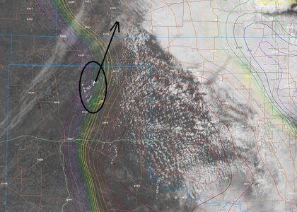
latest sat shot showing some possible towers nowMETSAT.jpg

The NW portions of KS into CO are also a good place to be. Decision time is now to take the trip north ... or take the risk and stick to SW KS, NW OK.. I bet it's why the SPC hasn't put out a MCD for SW KS yet.. because they are trying to assess the clouds and the areal coverage of the risk area..
 
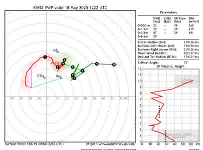
one last point of note for the SW KS / NW OK area... the fact that storm vectors are going to be from about 200 to 230 moving NNE 020 to 040 initially before shifting more easterly so, that might give them more time in the clearer air and hopefully that OVC deck continues to shift off back to the east some more to as the warm front lifts, which it appears to be doing, slowly.

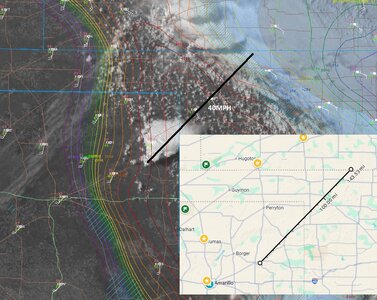
as the crow flies, the distance from the area circled in my last post to the OVC deck on that Vector line is about 100NM. So you figure 40-50KTS.. is about 2 hrs or so if the storms formed in the next hour. And that's all static of course for reference, if the storms form closer to the east, or the OVC deck keeps retreating, well you get the idea.
 
At one point was tempted to bail south into the clearing in W-OK, but decided to hold tight in Buffalo OK based on satellite trends and that seems to have paid off as the skies are looking pretty classic. It’s a rather narrow zone of instability between the dryline and warm front / cold pool to the east, but hopefully the warm sector expands with time as warm advection continues and cloud cover continues to erode.
 
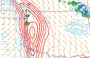
Yeah it's still a little cool in the heart of the Kansas MDT. It's recovering, but clearly not as fast as points south. I like meeting up with cells along the TX/OK Panhandles border. (5:15 CDT)

Note that the so-called Northwest Target is working off strong low-level storm-relative shear though less extreme CAPE. Seems parts of southwest Kansas don't have quite enough of either. (could change)

Tough call to drop south, because one is committed versus hanging north with these storm motions. It's after 5pm local, so time to make the call. Panhandle cells.
 
I gotta admit, I am a little perplexed at the reason behind the Arnett storm fizzling out. was it terrain issues just disrupting inflow? .. I can hear the underperforming comments flowing from frustration. its still located in solid dynamics.. maybe something in the boundary layer and below? or something at 700.. destructive interference from the other cell? ....something choked it off and I am not seeing what.. down stream temps and dews still look good..

its odd, but there's a reason, I just cant see it yet. maybe the merger will help it before it gets dark.
 
Last edited:
I gotta admit, I am a little perplexed at the reason behind the Arnett storm fizzling out. was it terrain issues just disrupting inflow? .. I can hear the underperforming comments flowing from frustration. its still located in solid dynamics.. maybe something in the boundary layer and below? or something at 700.. destructive interference from the other cell? ....something choked it off and I am not seeing what.. down stream temps and dews still look good..

its odd, but there's a reason, I just cant see it yet. maybe the merger will help it before it gets dark.
I have been wondering the same thing all evening. There should have been at least another solid hour of good parameters before hitting that stable air from the earlier cloud cover.

Would definitely love a theory/ explanation from someone.
 
Back
Top