Mike Smith
EF5
Based on the 12Z and 18Z runs today (Tuesday), it would appear that Friday has significantly more potential than I first thought. And, it looks like the synoptic situation will favor those who have been looking forward to an "old fashioned Kansas storm chase."
What looked like the biggest limiting factor was moisture; but the newer models have Td's >55°F all the way to Winfield (KWLD) by 18Z with Td's in the 60's south into Oklahoma and Texas. By early afternoon, the GFS has CAPE values >1500 in Kansas and >2500 in Texas. Surface pressures are surprisingly low for mid-April with a 992mb low forecast on the KS-OK border NNW of Woodward on the GFS and farther north into KS on the UKMET and ECMWF, just west of Great Bend.
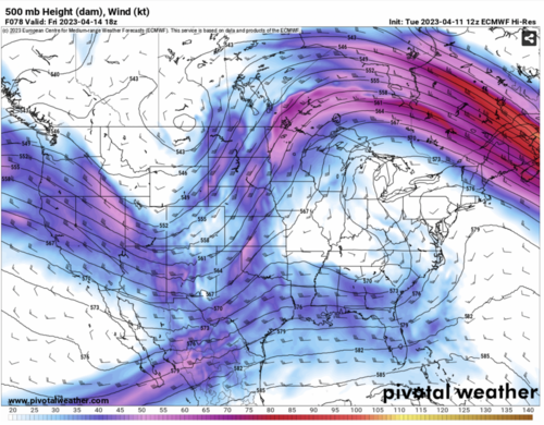
The dynamics look highly favorable without being "too favorable." The ECMWF, UKMET and Canadian all have a negatively tilted trough moving into the 4-corners area at 12Z and into E NM by evening. From a synoptic climatology point of view, this is highly favorable. While PFJ and STJ's are not overly strong, they are diluent. Generally, with sufficient, but marginal, moisture, I've generally found that the dynamics can be "too good" and the system doesn't produce. This looks like a very favorable balance. I have attached the ECMWF 500mb forecast for 18Z Friday.
I would judge the highest risk to be in Kansas and Oklahoma along and east of I-35 and north of I-40 with a lesser risk farther south to about Waco.
Of course, this is still early and things may not be as favorable as they seem. If I had to guess at this point, I'd probably forecast a 10-15% hatched to the right of a line from OKC-ICT-SLN-TOP-TUL-MKO-OKC. I'd do 5% ACT-FSI-END-HUT-CNK-40 N TOP-MCI-JLN-FSM-ACT.
Please allow me to state again that this is preliminary but I thought I would get this out there in case it is helpful for planning purposes.
I don't want to take a shot at Saturday yet.
What looked like the biggest limiting factor was moisture; but the newer models have Td's >55°F all the way to Winfield (KWLD) by 18Z with Td's in the 60's south into Oklahoma and Texas. By early afternoon, the GFS has CAPE values >1500 in Kansas and >2500 in Texas. Surface pressures are surprisingly low for mid-April with a 992mb low forecast on the KS-OK border NNW of Woodward on the GFS and farther north into KS on the UKMET and ECMWF, just west of Great Bend.
The dynamics look highly favorable without being "too favorable." The ECMWF, UKMET and Canadian all have a negatively tilted trough moving into the 4-corners area at 12Z and into E NM by evening. From a synoptic climatology point of view, this is highly favorable. While PFJ and STJ's are not overly strong, they are diluent. Generally, with sufficient, but marginal, moisture, I've generally found that the dynamics can be "too good" and the system doesn't produce. This looks like a very favorable balance. I have attached the ECMWF 500mb forecast for 18Z Friday.
I would judge the highest risk to be in Kansas and Oklahoma along and east of I-35 and north of I-40 with a lesser risk farther south to about Waco.
Of course, this is still early and things may not be as favorable as they seem. If I had to guess at this point, I'd probably forecast a 10-15% hatched to the right of a line from OKC-ICT-SLN-TOP-TUL-MKO-OKC. I'd do 5% ACT-FSI-END-HUT-CNK-40 N TOP-MCI-JLN-FSM-ACT.
Please allow me to state again that this is preliminary but I thought I would get this out there in case it is helpful for planning purposes.
I don't want to take a shot at Saturday yet.
Attachments
Last edited: