Thomas Mattek
EF0
Look at this beauty. A stout lil tornado off of a discrete supercell southeast of Wichita, and hundreds of miles south from the
SPC's 2% tornado risk. So what gives?
So to start with, let's look at the environment around 0030Z(7:30) central time, about an hour after the tornado was produced
and in the environment behind the supercell. Of note, 200+ SRH, low LCLs, and decent instability are all present.

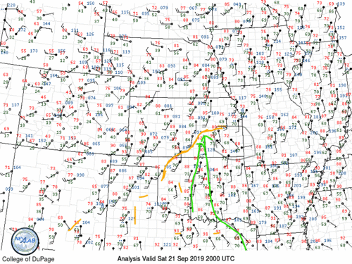
But this is a pre-frontal, moist, sheared environment. As we see from this 23z mesoanlaysis, there was a broad area of
SRH, even with fairly weak bulk shear of 30-35 kts.

Any supercell in this environment probably had tornadic potential, but this initiated on the OK/KS border around
Blackwell and Arkansas City. By 2031 Z it already had a well-developed mesocyclone, implying a strong micro-environment. Props to Will Everett for this screenshot.

Let's look at some of the parameters: I've attached here Theta-E, 0-3KM CAPE, and SBCAPE at 20Z. Big shoutout to @CameronJNixon
for pointing me to the RAP mesoanaylsis archive.
Notice that the instability is locally maximized near this region, particularly the lowest level instability. This low level
instability bullseye is located just south of the area where the supercell initiated, and that area is roughly on the top
of the Theta-E bloom as well.


So what gives:? Why was instability concentrating on this region in particular?
I went back and did some crude surface analysis, and I believe it's a product of moisture convergence. There's a
very clear line of winds carrying high moisture air toward lower moisture air in mid-Kansas. I believe this mixing caused surface convergence to the south, which resulted in extremely strong low-level lifting in an already unstable environment.
.gif")
With an atmosphere already primed to go, the supercell was able to take advantage of low-level shear(100+ 0-1SRH)
and form a tight mesocyclone by 2109Z. I also noted backing winds northeast, but I no longer believe they were a significant factor
The surface instability parameters drop off in subsequent hours, but they had already done their job of initiating a storm, and there was no other forcing to cause competition. From then on it tracked along with the areas of higher shear until it produced a tornado by 00:15Z. Given the meso signature at 21Z, and the fact that this initiated in an environment of high surface instability, it may have produced before that.
To summarize: I believe low-level moisture convergence led to high surface instability which was just enough to kick off a discrete storm in a good environment. This would have been extremely hard to forecast in real-time, with the largest clue being the concentration of 0-3KM CAPE near north-central OK to south-central Kansas.