cdcollura
EF5
Good day all, I will start this thread (please merge it if not already a thread for it) on May 29, 2019 … This is for Iowa...

Above: May 29 was both a marginal chase day and travel day, since I was already en-route to Chicago for down time during the succeeding days. Despite a large enhanced area to the far south and east (with a 10% tornado area in SE Texas and well out of reach), I decided on the "cold-core" setup in eastern Iowa, which had a 2% tornado outlook as per SPC at 1630z. The tornado probabilities and my target area are shown to the left. Both produced significant tornadoes. The middle image shows Mesoscale Discussion 882 for the far and distant SE Texas target. To the right, is Mesoscale Discussion 885 for my area targeted in eastern Iowa (no watch was issued there).
Chase Summary: May 29 was supposed to be a travel day since the pattern finally was forecast to wind down over the next week, and the high probabilities for severe weather were basically out of reach in far eastern / southeast Texas for the day. The SPC had this area in an enhanced risk as of 13z and 1630z, with a 10% tornado probability (hatched on the 13z outlook), and a 30% wind and hail outlook (hail was hatched for significant). This area extended north and east though the SW Ozarks. Surrounding this outlook was a 5% and 2% tornado outlook, and my focus was the marginal 2% from central to eastern Iowa. Not only was this on the way back (eventually to Chicago) for downtime, but was quite interesting since there was a surface low and occluded front with upper level low above it (a "cold core" setup). I left Topeka via Highway 75 north to Highway 36 east into Missouri and Cameron (to avoid flooded areas and the toll roads / tornado damage near Kansas City). I headed north on I-29 to I-80 east of Des Moines, reaching Iowa City by late afternoon for the nightly stay there, checking into my hotel. The "target area" was fortunately just west of this area. The SPC had Mesoscale Discussion 895 active for this area (no watch was needed). A storm chase was done in this area, and I was rewarded with beautiful supercells and funnels / tornadoes! I wrapped up this "mini chase" and leisurely went back to the hotel in Iowa City for the night.
Storm Interception Details Are Below
1). May 29, 7:30 PM - Interception, penetration, and observation of severe and tornadic thunderstorms over Iowa County, Iowa near Williamsburg and north of I-80 west of Iowa City. The storm began as a small supercell storm that split into at least another during its cycling along I-80 and Highway 6. These small supercell storms produced numerous funnel clouds and a couple of tornadoes which were observed. Heavy rains, small hail to 3/4 inch, occasional lighting, and 60 MPH winds were also encountered. The tornadoes were brief but photogenic, as the supercell storms were LP to classic in nature. At least one supercell had a striated appearance and well developed RFD slot. Conditions causing the storm were surface heating, an occluded front (arcing confluence / shear axis), surface low, and upper level low (basic cold-core setup). Documentation was digital stills and HD video. A 2016 Jeep Wrangler was used to chase the storms.
Pictures For May 29, 2019 Are Below
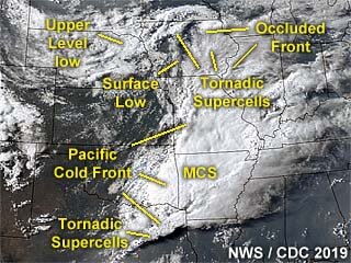
Above: Annotated satellite image showing convective evolution and the synoptic setup during the afternoon of May 29, 2019. The main area chased was in eastern Iowa, owing to a cold-occlusion and "cold-core" environment east of a surface low.
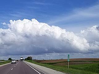
Above: Convective initiation along a cold-occluded front / confluence line east of a surface low west of Iowa City and east of Des Moines, Iowa during the afternoon of May 29. The view is to the east along I-80.
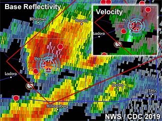
Above: Doppler (base reflectivity) radar image of a tornadic supercell west of Iowa City and near Williamsburg, Iowa late in the day on May 29. The inset shows the intense Doppler velocity as well as my position in the blue cross-hair circle.
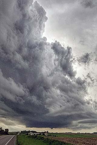
Above: Small supercell storm and funnel near Williamsburg, Iowa late in the day on May 29. The view is to the SSW.
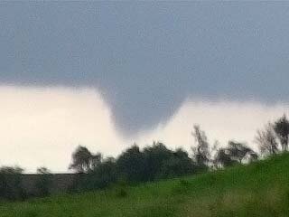
Above: View of funnel / developing tornado on a small supercell storm near Williamsburg, Iowa late in the day on May 29. The view is to the SSW.
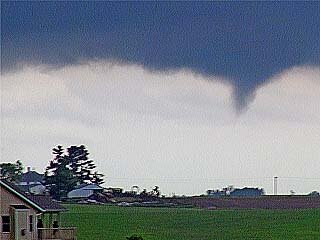
Above: Another view of the funnel / developing tornado near Williamsburg, Iowa on May 29 a few minutes later.
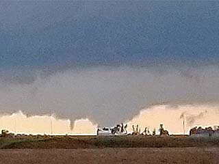
Above: View looking west towards a possible large tornado and satellite funnel rotating around it west of Williamsburg, Iowa late on May 29. The view is to the west.
Note: For DETAILS on this storm / setup as well as others in May 2019 … Please visit the link BELOW for more information!

Above: May 29 was both a marginal chase day and travel day, since I was already en-route to Chicago for down time during the succeeding days. Despite a large enhanced area to the far south and east (with a 10% tornado area in SE Texas and well out of reach), I decided on the "cold-core" setup in eastern Iowa, which had a 2% tornado outlook as per SPC at 1630z. The tornado probabilities and my target area are shown to the left. Both produced significant tornadoes. The middle image shows Mesoscale Discussion 882 for the far and distant SE Texas target. To the right, is Mesoscale Discussion 885 for my area targeted in eastern Iowa (no watch was issued there).
Chase Summary: May 29 was supposed to be a travel day since the pattern finally was forecast to wind down over the next week, and the high probabilities for severe weather were basically out of reach in far eastern / southeast Texas for the day. The SPC had this area in an enhanced risk as of 13z and 1630z, with a 10% tornado probability (hatched on the 13z outlook), and a 30% wind and hail outlook (hail was hatched for significant). This area extended north and east though the SW Ozarks. Surrounding this outlook was a 5% and 2% tornado outlook, and my focus was the marginal 2% from central to eastern Iowa. Not only was this on the way back (eventually to Chicago) for downtime, but was quite interesting since there was a surface low and occluded front with upper level low above it (a "cold core" setup). I left Topeka via Highway 75 north to Highway 36 east into Missouri and Cameron (to avoid flooded areas and the toll roads / tornado damage near Kansas City). I headed north on I-29 to I-80 east of Des Moines, reaching Iowa City by late afternoon for the nightly stay there, checking into my hotel. The "target area" was fortunately just west of this area. The SPC had Mesoscale Discussion 895 active for this area (no watch was needed). A storm chase was done in this area, and I was rewarded with beautiful supercells and funnels / tornadoes! I wrapped up this "mini chase" and leisurely went back to the hotel in Iowa City for the night.
Storm Interception Details Are Below
1). May 29, 7:30 PM - Interception, penetration, and observation of severe and tornadic thunderstorms over Iowa County, Iowa near Williamsburg and north of I-80 west of Iowa City. The storm began as a small supercell storm that split into at least another during its cycling along I-80 and Highway 6. These small supercell storms produced numerous funnel clouds and a couple of tornadoes which were observed. Heavy rains, small hail to 3/4 inch, occasional lighting, and 60 MPH winds were also encountered. The tornadoes were brief but photogenic, as the supercell storms were LP to classic in nature. At least one supercell had a striated appearance and well developed RFD slot. Conditions causing the storm were surface heating, an occluded front (arcing confluence / shear axis), surface low, and upper level low (basic cold-core setup). Documentation was digital stills and HD video. A 2016 Jeep Wrangler was used to chase the storms.
Pictures For May 29, 2019 Are Below

Above: Annotated satellite image showing convective evolution and the synoptic setup during the afternoon of May 29, 2019. The main area chased was in eastern Iowa, owing to a cold-occlusion and "cold-core" environment east of a surface low.

Above: Convective initiation along a cold-occluded front / confluence line east of a surface low west of Iowa City and east of Des Moines, Iowa during the afternoon of May 29. The view is to the east along I-80.

Above: Doppler (base reflectivity) radar image of a tornadic supercell west of Iowa City and near Williamsburg, Iowa late in the day on May 29. The inset shows the intense Doppler velocity as well as my position in the blue cross-hair circle.

Above: Small supercell storm and funnel near Williamsburg, Iowa late in the day on May 29. The view is to the SSW.

Above: View of funnel / developing tornado on a small supercell storm near Williamsburg, Iowa late in the day on May 29. The view is to the SSW.

Above: Another view of the funnel / developing tornado near Williamsburg, Iowa on May 29 a few minutes later.

Above: View looking west towards a possible large tornado and satellite funnel rotating around it west of Williamsburg, Iowa late on May 29. The view is to the west.
Note: For DETAILS on this storm / setup as well as others in May 2019 … Please visit the link BELOW for more information!


