2019-05-22 REPORTS: IL/KS/MO/OK/TX

First post. I've been a spotter in the Fort Worth area for several years, but decided to become a "mobile spotter" this year. These were taken WSW of Okmulgee around 5:30pm (Dripping Springs Lake). This was my first time out...spent most of the afternoon trying to catch up to the storm from the south. Maybe spent an hour with eyes on it before turning around and heading home. Learned a lot, mostly just tried to stay out of the way.
 

Attachments

  • IMG_0015.JPG
    IMG_0015.JPG
    222.8 KB · Views: 0
  • IMG_0017_8x10_2.JPG
    IMG_0017_8x10_2.JPG
    195.4 KB · Views: 0
  • IMG_0026.JPG
    IMG_0026.JPG
    126.6 KB · Views: 0
This was my most successful chase day of 2019. The first storm produced at least one tornado just west and north of Okemah. The second storm produced multiple tornadoes from Okemah to SW of Nuyaka, Oklahoma. (west of Okmulgee.) This chase was extremely challenging due to trees, traffic blockages, tornado damage and dirt roads. I've edited this video and included times, radar images and locations and aspects of the entire chase day. I started the day chasing with a large group of friends, and we did our initial forecasting together. The initial target was Prague, OK. Chase group in no particular order: Jason Persoff, Scott McPartland, Dave Lewison, Chris Kridler, Alethea Kontis, Mark Robinson, Jaclyn Whittal, George Kourounis, Dayna Rousseau and Brad Rousseau. This video is available for licensing.

 
Ended up chasing in Western Illinois that afternoon on 5/22. Got off work around 2 that afternoon and ran home to grab my camera, and other gear. By that point cells had already fired by the time I started heading South and West. Storm near Carthage looked LP and had a persistent wall cloud to it, though it remained high based. As that storm died (capping and moisture issue) I stuck around in the area for the next 2-3 hours, wondering if any storm had a chance. Naturally Davenport (DVN) radar went down and I had noticed that on Lincoln’s (ILX) Radar that a cell headed for the La Harpe area had a bit of rotation. As I got closer to the town, I noticed the storm morphed and had a clear view of the base and wall cloud. I watched this storm move a mile or two north of town and it briefly had some inflow. However it died off soon after, and was followed by nice structured LP storm. No tornadoes for me that day, but I saw some amazing structure nonetheless.
 

Attachments

  • 619BE423-41E0-490D-8ED1-7356DAF46052.jpeg
    619BE423-41E0-490D-8ED1-7356DAF46052.jpeg
    201.4 KB · Views: 0
  • 450F7EEF-4DD6-4170-87DA-D9E5FBA8FDB4.jpeg
    450F7EEF-4DD6-4170-87DA-D9E5FBA8FDB4.jpeg
    97 KB · Views: 0
  • 5ED69D07-B23D-4070-809F-76F3FC779C3D.jpeg
    5ED69D07-B23D-4070-809F-76F3FC779C3D.jpeg
    125.8 KB · Views: 0
Last edited:
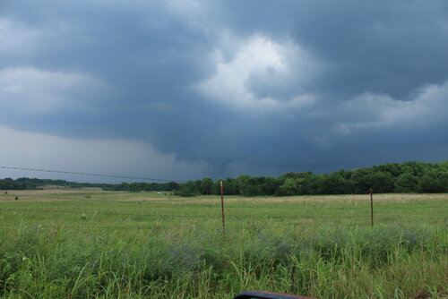
We started this day off out of Wichita after busting on the cold core setup the day before. After scrutinizing posted road closures and construction zones, we got moving and stopped near Pittsburgh, KS. Around 00Z a tornado warned cell nudged us into Missouri for a first attempt before it weakened as it moved out of Kansas. Another cell was strengthening to its southwest though, so we headed south to Carthage and explored vantages and road network as that one approached.

I was surprised how consistently paved the roads were in the area. As long as we could stay out of the river valleys, the grid tested out excellent with a lot of good visibility. I wound up liking Base Line Blvd southeast of Jasper for an intercept that would keep us in flatter terrain to pace on to the northeast for a reasonable distance before Stockton Lake would become a problem.

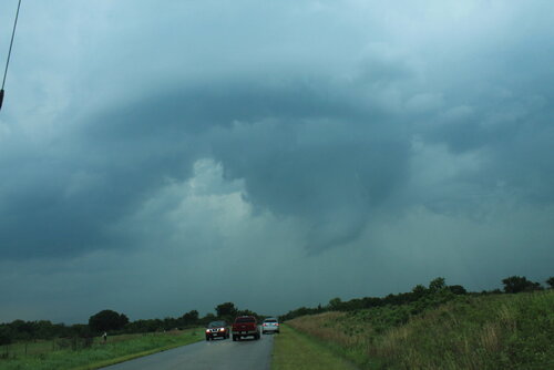
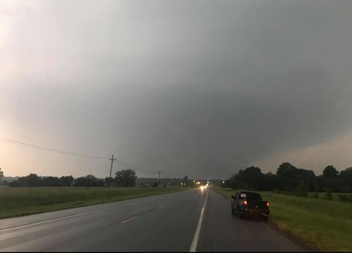
I jockeyed back and forth to make sure my escape routes and vantages looked good. The sun had gone down and it was getting dark just as the base and wall cloud started to take shape to the southwest. What unfolded next was so like my storm-photography nightmares that I caught myself actively wondering if I was actually having a dream. I was just a few days into actively using a new camera and lenses and as much as I thought I’d developed reflexive control and worked out any glitches, I was totally wrong. The first surprise issue was back button focus not working, which quickly morphed to the aperture not adjusting from the dial I thought I had it set for, which then cliff-dove straight into some horrifying card-write error. All of this while the storm was quickly winding up about 3 miles southwest and closing.

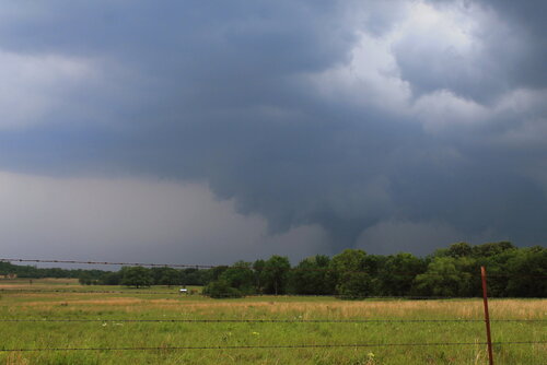
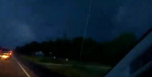
0146Z — Blurry shots as storm approaches with possible funnel/debris toward left side—didn’t notice that smaller detail in the gloom at the time.
19007

The first couple issues were frantic forgetfulness on my part, but the third glitch was due to a unique lens-camera-zoom-preview settings combo bug that I didn’t figure out until a couple weeks later. At the time, it was all just nightmare gremlins in deep twilight when every setting is critical, with a dangerous storm bearing down. After rebooting the camera a couple times, we jetted east a couple miles and tried again. By this time, I had re-set the camera to factory settings, which probably made things worse, and now I didn’t have decent light sources to focus on.

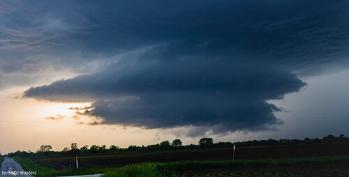
With my brain fried by technical issues and a ton of missed shots, I couldn’t actually tell that the storm was producing, other than it had developed a huge, incredibly solid wall cloud slanting above the trees. I didn’t pick up on the power flashes visually at the time, but the camera caught one as it illuminated the tornado in progress about a quarter mile northeast of where the first damage markers were surveyed. My daughter was running the video camera and picked up a couple more power flashes after that. We didn’t get an actual visual on the condensation funnel until about 20 minutes later as it was backlit by lightning as the storm was racing off north of Golden City.

0152Z — Power flash illuminating tornado as it crossed 100th Rd. north of Rosebud 3 miles to our northwest.
19008


0153Z — Video frames of power flashes as it approached 90th Rd. south of Sumac.
19009


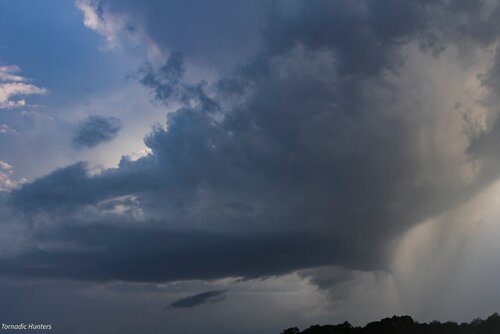
0154Z — Wall cloud and RFD shelf — tornado obscured by large tree at center.
19010


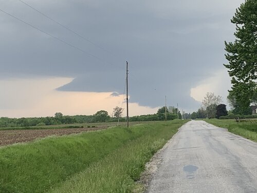
0217Z — Backlit funnel north of Golden City, about 8 miles to our north.
19011


We paced it for a while, but terrain and trees gradually became a huge problem as we got east of Lockwood. We made our way back west to the next day’s target in the Texas Panhandle, dodging heavier cores and flooded roads along the way during a very long night of driving.

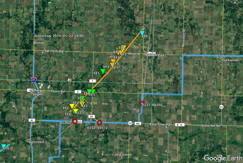
Map of image locations and damage survey.
19013

The next day was a punch in the gut to realize that the whole time I was aggravated and stressed about camera problems, the storm was taking three lives just a few miles up the road as it approached Golden City. I can’t rationalize feeling positive about that day, just grief for the families of Betty Berg and Kenneth & Opal Harris.
 

Attachments

  • img20190522_StormPhotoMap_1280pxNWM.jpg
    img20190522_StormPhotoMap_1280pxNWM.jpg
    944.3 KB · Views: 0
Last edited:
I have still yet have had time to go through pics and video of this day, once I do - I will try post some additional pics/videos as I can.

After catching up with Dan Robinson in Altus a few days prior, we found ourselves starting the last day of this tour in Tulsa. I decided to play upstream in far northern Oklahoma/southern KS. Got the tour on the supercell near Commerce OK (north of Miami, OK) We believe we documented a large tornado just north of Commerce but visibility was poor at best from our vantage point and just as everyone else, we had trouble navigating flooded or closed roads.
All actions hinged on the current road closures/issues and I made the call to drive north further upstream on a developing cell that was just crossing the border into KS.
We bailed on the Commerce storm and somehow got into position near Baxter Springs, KS and documented a large roaring wall cloud (becoming tornado warned just as we got a good look at it) However, in my haste to put us upstream, I put us directly between two tornado warned supercells.

Gambling that the southern cell would be our best bet, and because it had indeed produced a confirmed tornado north of Commerce, I busted us east on 166 and waited on the Commerce cell. After allowing the front flank to pass us I made the call to sling shot us into the notch near Baxter, Springs, KS. As we were parked on 166 in Baxter Springs, we documented a large tornado southwest of Baxter. This ultimately lifted and we were left looking right into the vault area of the supercell and mesocyclone as it crossed 166. We followed the supercell northeast through Galena, KS just as it produced one and then 2 additional quick brief cone tornadoes north of Galena.
Trying to stay with the storm became pretty tough at this point but we continued somehow managing to stay just a mile or so south of the circulation. We began thinking the worst would be likely as we came into Joplin. I went live on Facebook as I thought we were viewing a large tornado but I couldn’t tell with 100% certainty due to low contrast and being directly south of the circulation/rain wrap. As the supercell neared Carl Junction/north Joplin we had interest north Joplin and were heading north on 43HWY - I got the first glimpse of the large wedge tornado as power flashes lit up the left edge and then the entire tornado.
I believe it was about to go into Carl Junction at this point.
We hit Airport drive at this point and the tornado was just to our north/northwest. We could see lofted debris and at some points, almost continuous power flashes.
Nearing the town of Oronago, MO we witnessed and documented the tornado as it morphed into an extremity large wedge with what I believe was a slender satellite tornado buried in the rain right on the edge of the collar cloud.
Traffic became more if an issue, and not wanting a repeat of what took place near Mangum just a few days prior, I decided to try and play secondary roads. This was obviously a big mistake due to continued flooding. We made it about 5 miles northeast of Jasper, MO when we hit the damage path again and the road was closed. The large tornado continuing to move east away from us but appeared to morph into its widest point just to our east.

I called the chase at this point because we had an additional tornado warned supercell southwest of Joplin in Oklahoma and we had to get guests back to hotel in Tulsa.

Hitting 44 we busted back southwest towards Tulsa and documented another large tornado looking back towards Bluejacket, Oklahoma as we were trying to get into Vinita. I’m not sure if anyone else documented this tornado but we did hear of reports of damage just south of Bluejacket.

Horrible to hear of the fatalities near Golden City. All in all we documented 4 separate tornadoes from two separate supercells with a possible 5th tornado back near Commerce, OK as previously mentioned. So glad Joplin wasn’t a repeat on it’s “anniversary” as we had thought it might be. The entire month of May was tough navigational wise to say the least.
 

Attachments

  • 742FE5E4-5219-4008-9D3C-872474A0B222.jpeg
    742FE5E4-5219-4008-9D3C-872474A0B222.jpeg
    59.2 KB · Views: 0
  • 0A32E7DE-90CA-476F-94C9-E59C45B4F5B6.jpeg
    0A32E7DE-90CA-476F-94C9-E59C45B4F5B6.jpeg
    135.8 KB · Views: 0
Started the day waking up in OKC and targeting the area north of Tulsa for tornadoes. We drove to Owasso to re-evaluate the day. About this time, storms were just forming near Shawnee. I was very concerned about the flooded roads in our target area. So after checking mesoanalysis, we decided to drop south along highway 75 and put ourselves ahead of the developing storms. After a few scans, I was glad we made this decisions. Storms in our original target were looking good but there was a lot going up at once. Once in Okmulgee, we went west towards the northern storm to see what we could get out of it before the southern storm would eventually take over. We watched a beautiful snake-y rope for several minutes on a hill southwest of Nuyaka. We then focused on the storm south of it as it was producing the larger tornado northeast of Okemah. Once we lost that tornado in the rain, we continues tracking these storms east and north. We briefly saw another tornado way off to our north near Haskell, OK while trying to keep up with the storm. Eventually caught the trailing supercell near Pryor, OK where we encountered a fairly decent lightning barrage. As the sun set, we watched the last storm cause power flashes near Salina, OK. And I'm 95% sure we could see a tornado under a very low wall cloud (video didn't come out so great due to lighting). All in all, 4 tornadoes on an audible last minute call.


full


Tornado #2 north of Okemah, OK
 
Back
Top