2019-05-22 REPORTS: IL/KS/MO/OK/TX

Joined
Jun 16, 2015
Messages
476
Location
Oklahoma City, OK
I'll start off by saying that I did not capture much in the way of photos or videos, but did catch at least two tornadoes with the southernmost of two supercells in east-central/northeastern Oklahoma.

I stayed at my apartment in Oklahoma City, just about all day. I initially thought I would target the KS/OK border area, north of Tulsa, but after witnessing flooded roads and reviewing Google Maps, I decided against it. I figured that western Missouri was too far to go, so what did that leave me with? I was very skeptical about sustained convective initiation south/southwest of Oklahoma City, especially after seeing the 17z OUN sounding. I decided to hang back and wait. I even toyed with the idea of not chasing at all.

By mid-afternoon, I was growing increasingly intrigued by cells that were initiating just east of Shawnee. For whatever reason, I waited until just about the last minute and walked out the door around 4 p.m. Luckily I only hit a few bouts of traffic, as if I had waited much longer, the chase might have been completely lost.

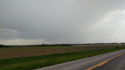
I saw two dueling supercells riding along I-40 and I made good time catching up, as they weren't moving very fast. Once I got to Okemah, I had a visual on a very low, grungy wall cloud, just to the southeast of I-40. Vehicles were stopping and traffic was slowing, but thankfully I did not see anyone parked under underpasses and most people pulled off as they got closer to the mesocyclone.

I noticed a few brief funnels/tornadoes, but for the sake of this, I'll consider it one tornado. I had a video camera going on my roof, but due to raindrops and haze/smoke, as well as not being super close, the video didn't seem to pick up on any of this activity.

The wall cloud, very clearly rotating, passed over I-40 in front of me and then I eventually pulled over. The video above is just a brief clip, but it's probably the only interesting video that I captured. I sped up the video to 4x to enhance the rotation. I could feel the rush of the air with my windows open as the wall cloud passed nearly overhead. I don't often get this close to a tornadic supercell and it's probably fortunate that it wasn't producing a tornado at the time, as I-40 might have been blocked off.

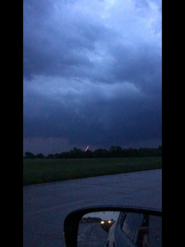
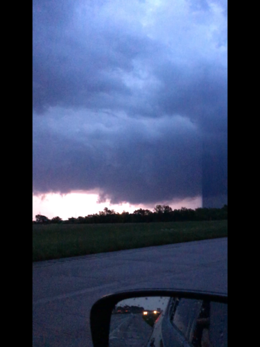
I managed to take one picture and it shows the grungy wall cloud, which was literally on the cusp of tornadogenesis. Just a couple of minutes later, a firm stovepipe tornado was in progress. I have little doubt that it was a significant tornado. With that said, I got off I-40 and maneuvered my way north and east, only catching brief glimpses of the tornado. As I got closer, trees became more of an issue, as well as muddy/rough roads.
wall_cloud_190522.jpg

I continued northeast and near Okmulgee, it looked like the supercell might be cycling. The original tornado had lifted and another low-hanging wall cloud popped up to its immediate east. That's about all she wrote, though, as once I got to Pumpkin Center and hit some really awful roads (large pot holes, mud, etc.), and saw that I was approaching a larger population area, I bailed. That was it. I almost thought about trying to rush toward the storms east of Stillwater, but I'd had enough.

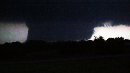
Video was recording for the whole event on my roof, but as I wandered northeast of I-40, trees and powerlines obscured view about 90% of the time, so it's not worth sharing. This low resolution screen capture is the only official image of the tornadoes I can share:
screencap_190522.jpg

On the way back home, I saw the debris signature of another significant tornado, passing just north of Joplin. It was a grueling day. Chasing in the borderline woods of eastern Oklahoma, fighting with a tough forecast and then watching tornadoes do damage. It was very sobering. The tornado north of Joplin was probably a long-tracker and legitimately large from the photos I saw. A lot of times when a tornado is labeled "large," it's really not, but in this case, it most certainly was.

I'll count this as a two tornado event in northeastern Oklahoma, my first tornadoes up here. As I mentioned on Twitter, I don't mind if they are my last. Over time, I grow less and less fond of tornadoes doing damage in wooded, populated areas. I think most of us would rather chase out over open country, where it's easier, safer, usually more photogenic and less destructive.

With that said, it was a fairly local chase. Even though I didn't leave until about 4 p.m., I was back around 9 and logged one of my shorted distances driving for a storm chase so far this year.
 
Last edited:
Followed this amazing supercell from Welch Oklahoma to Golden City Mo. This is my backyard so I know the roads well but it was still difficult with flooding of the Neosho river as well as damage. I understand there are fatalities with this wedge tornado as it passed northwest of Golden city. Alas, here’s my crappy distant shots 5E19DB4B-C04A-4983-B9B4-B0B1803A3FB0.jpeg5E19DB4B-C04A-4983-B9B4-B0B1803A3FB0.jpeg4A874B3C-6467-485F-9B2E-35A91D5995A0.jpeg4EDF3D8A-C845-44ED-B2BD-A6EF397FC491.jpegCF0EC314-6606-49C1-AD08-93DC07230356.jpegB990AAF5-5B31-4CCA-BB3A-F18F199AC2EE.jpegE0C0C257-2E5E-48AE-AD39-74D2F61F5ACF.jpeg
 
Does anyone have photos of the tornado near Pryor, OK around 8:15-9pm?

I was in the core heading east straight toward Pryor with the intention of getting southeast a bit to position myself back outside of the cell, but I checked the time and decided to turn back and head home since sunset was nearing. I would love to see some photos of what I missed! I had a feeling I'd be kicking myself for that.

Nice to see the photos of the Golden City tornado as well, as that is the backyard of where I grew up.
 
Chased Northeast MO/West Central IL today due to having to come home and fix my vehicle (otherwise I'd have been in SE KS). Got on 3 different tornado warned storms, didn't capture a lot of imagery due to darkness. However I captured quite an LP supercell near Lima, IL and then a possible tornado near Canton, MO. Not really sure if it was just condensation being pulled into the storm or a tornado. NWS LSX has LSR'd it as a tornado however....we will see. If anyone else has any evidence, let me know. Here are a couple captures, definitely nothing on par with KS/OK, but for an hour and a half from home, I will take it.

18305

18307

The last 2 are screen grabs from some crappy video I shot from a moving vehicle outside Canton, MO.

18308

18309

That is all I have for today. I'll wait to see if LSX confirms this as a tornado for sure or not, would be cool if they did because I'd be 3 back to back to back tornado days which would be a first in my "career".18337

Edit: I looked over my video and I discovered this possible tornado northeast of Rushville, IL around 10pm. Pronounced RFD cut and mesocyclone at least.
 
Last edited:
Started out the day by Topeka and drove South into OK where we met a supercell heading North around Adair OK. It went tornado warned about the time we got there. There was a lot of concern about secondary roads being closed so it took until just West of Miami to get a view of a tornado on the ground. Just when we started to get a great view the police roadblocks starting happening. We had to get creative in skirting the blocks while getting a crappy low contrast view of the growing wedge. Chased until we got to a residential area of Carl Junction where there was a lot of damage over a wide area. We cleared trees from the roads for emergency services and checked on homeowners until deep into the night0FBE1F49-B14E-44C8-9215-0137CFC84145.jpegView attachment 18313View attachment 183137E55B15A-38DA-4420-8FD6-AD57ADFFC152.jpeg
 
Last edited:
I played around with some of the storms in northeast Missouri and west central Illinois after work. Early on storms looked interesting, developed nice rain free bases, a few wall clouds, and some severe hail amidst initial tornado or SVR thunderstorm warnings. However, as storms worked north, they appeared to be struggling with capping issues and a less favorable low-level environment, until conditions improved between 0z-1z. By the time storms did finally mature during sunset, it was hard to get a good, clear shot of anything better than low hanging, ragged wall clouds and some circulations aloft.

18316
 

Attachments

  • Twitter_20190522_181124.jpg
    Twitter_20190522_181124.jpg
    236.4 KB · Views: 0
I saw no tornadoes but did see 4 wall clouds from 3 separate circulations. I first intercepted the long lived supercell that had produced near Okmulgee. I met up with it north of Haskell on Highway 72. Me and another local chaser named Matt watched that wall cloud for several minutes. It looked promising at first but it was weakening. Next I drove north, got on the Muskogee turnpike and intercepted a new storm that was moving NE from south Tulsa. I saw a wall cloud to my west from the intersection of the Muskogee and Creek turnpikes, and a few minutes later it went tornado warned. I followed it north on the Creek toward Highway 412, but it didn't produce from what I could see. I lost it in rain and got on some back roads, making my way back to 412 just as the hook on radar was crossing 412 about 5 miles to my east. On Radarscope I could see dozens of chasers lined up along 412.

To avoid the hordes, I got off 412 near Inola and drove a few miles S to investigate a flanking line storm that had formed and started to show a new circulation on radar. It was a new wall cloud with frequent CG lightning coming from that area of the storm. This led to my best pic of the day, an apparent funnel 3/4 of the way to the ground 2 SW of Inola. The view is NW. It didn't appear to have rotation but sure looked impressive. The timestamp was 8:03 pm. I called it into the spotter net and watched it for several more minutes as it moved off to the ENE. Some chasers in a white car stopped by me during this time, gave me the thumbs up, and continued north directly under the wall cloud, which had lifted somewhat and didn't look quite as ominous.

18323

I then went back to 412 and continued east to follow the same wall cloud, or maybe it was the same circulation that had crossed 412 earlier. I followed it to near Chouteau, which is 10 mi S of Pryor. It showed no signs of producing and it was getting dark, so I turned around and headed back home, ending my close-to-home chase. If I had wanted to night chase, I could have continued for at least 3 more hours with multiple tornado warnings and hook echoes north of Tulsa. What a crazy night.

Does anyone have photos of the tornado near Pryor, OK around 8:15-9pm?

Austin, the two pics below are video grabs of the wall cloud illuminated by lightning north of Chouteau (maybe 8 mi S of Pryor) timestamped at 8:30 pm. The view is NE. At that time anyway, it wasn't producing.

Ken
 

Attachments

  • Wall cloud N of Chouteau 1.png
    Wall cloud N of Chouteau 1.png
    835.3 KB · Views: 0
  • Wall cloud N of Chouteau 2.png
    Wall cloud N of Chouteau 2.png
    803.5 KB · Views: 0
Last edited:
Started out west of Baxter Springs, KS on highway 166. Intercepted the tornado warned storm south of Columbus and observed this wall cloud.

18324

Additional lightning shot taken with my iPhone using an app called iLightningCam:

18325

I live in Carl Junction, MO and the tornado that hit passed less than a half mile from my house. House is okay, but a lot of damage in the area.
 
My day started horribly as while driving from my room in Lawton to my target of Shawnee I blew a tire. I thought my day was over. I got my spare on and drove the rest of the way to Shawnee and went to Discount Tire, these guys were awesome and had me back on the road in under an hour. Once the two supercells went up east of Shawnee I decided the road options on the northmost storm were better despite the risk it might have gotten choked off by the southern storm. I saw this storms first tornado from quite a distance and then got a front row seat for its second tornado. It looked like the storm was going to cycle for a third time but I think the storm to the south finally choked off my storms inflow. Quite a turnaround from disaster to success for me.

 
Second bust day in a row thanks to bad chase decision making and/or execution. Starting from Wichita in the morning, I originally targeted Baxter Springs and began heading in that direction. I had my reservations about this area due to boundary-parallel flow and flooding, but felt it had the best potential for sustained convection over that in Oklahoma.

I normally make data check stops every 30 minutes or so during chase days, and after about an hour, started seeing the potential for solid convective initiation and sustainment in Oklahoma. This was enough for me to switch my target mid-chase to Oklahoma about 20 minutes before the PDS watch issuance. But upon making this choice, I could not verify that the route due south through Oklahoma was NOT flooded. Oklahoma's DOT map web site was down. Furthermore, several of the routes showed no live traffic data, which cast doubt on their viability. Worried that I'd encounter a closed road in Oklahoma with a 50-mile backtrack, I elected to play it safe and go back west to I-35 then south. This put the lead storms in the Shawnee area out of play for me.

I headed for the storm at Perry, which was encountering the frontal boundary (which by now should have been lifting north). But Stillwater's ASOS still showed northwest winds, and all of the wind turbines as I neared the area were pointing in that direction also. When I arrived on the storm south of Perry, it was already north of the boundary. Driving south of the storm, I finally encountered calm winds south of the front, but they soon shifted to the north - confirming the boundary was still pushing south as a cold front. This essentially killed my chase. There were new storms on this boundary to my west, but were a lost cause since they were already getting undercut.

The only other storms far enough south to not be in danger of the front undercutting were down south of I-40, but they slowly weakened as I approached, struggling with the cap. Finally, storms along I-44 began to sustain, but all but the one down at Wichita Falls were dominant left movers with no hope of rooting. I went over to one of them anyway at El Reno for lightning shots, but they weren't even producing that. My chase was over before sunset, and I headed to my hotel in Edmond.
 
I started out from just N of Tulsa, once storm formed in that area. Followed all the way past Golden City MO.

A lot of CG lightning. SW of Welch and NW of Vinita:

05/22/19. Welch OK to Golden City MO by lovnaoluje.com, on Flickr

From Vinita to Welch there were some weird acting cars driving 10/15 mph flashing all fours and occasionally stopping in the middle of the road. Long line formed behind this retards.

Between Welch and Miami US 59S was closed due to high waters so i took US 59N to US 166 to get to Baxter Springs. This maneuver led me right under a meso which approached me from SW on US69 US 166 intersection. Very loud roar, wind shifts, it was sucking huge amounts of warm moist air. Tried to make video to record that roar, but my lens was fogging up constantly. I manage to make one photo once it passed.

05/22/19. Welch OK to Golden City MO by Nikola Pavlovic, on Flickr

Past Baxter Springs i witnessed this tornado, which is according to NWS the beginning of Carl Junction tornado, just N of Galena

05/22/19. Welch OK to Golden City MO by Nikola Pavlovic, on Flickr

Night was coming so i decided just to follow the storm without taking any photo. I observed Golden City tornado until it roped out, followed the storm to Arcola, then gave up, since terrain became more and more wooded.
 
Last edited:
Wednesday looked like the in-between day when we rolled out on Sunday. Became our best intercept. Alas, this is why one should just be in the Plains all days of southwest flow aloft, esp if the LLJ is forecast to respond each evening.

Started in Wichita and lunched in Coffeyville, based on OFB location. Then we started toward Miami OK. Navigated around road closures toward the cell approaching from northeast Oklahoma. Met up with it near Bluejacket OK which is a little south of Miami. Had been hooking well for at least 20 minutes. As expected, tornado in progress.

This was before the larger wedge some documented near Commerce OK. We hit a police block from the south, but did glimpse a second brief tornado under that wide low wall cloud. Believe it was a new cycle, but maybe it was always there as we re-positioned from Bluejacket to Commerce/Miami.

We were not too disappointed about the road block. No heart to follow it toward Joplin; however, would have liked to see the Commerce wedge better. Here is about 30 minutes earlier (00Z-ish) a more finesse tornado west of Bluejacket OK.

IMG_-2ptptl.jpg IMG_20190523_014503_121.jpg
 
Good day all, Here is my report for storms in central / NE Oklahoma south of Tulsa for May 22, 2019...

18623

Above: A beautiful but strong tornado looms over an Oklahoma ranch near Wilson / Okmulgee looking westward late in the afternoon of May 22, 2019. On this same day, devastating tornadoes affected areas northeastward into Missouri in Jefferson City after dark. Storm chasing these incredible storms required deep respect for them, as well as being sensitive for anyone affected.

Chase Summary: May 22 was a challenging but very successful chase day with a highly visible tornado observed during the late afternoon in NE Oklahoma. I left Wichita late morning via Highway 400 east, then 77 south to 166 east for a primary target area south of Coffeyville, KS to near Bartlesville, OK near Highway 75. Severe flooding was encountered along this route, especially near Arkansas City, with fields looking like large lakes. Upon reaching the target areas, two areas of concern for convective initiation were noted, one east of Oklahoma City near Okfuskee County and another well southwest of Oklahoma City. The former proved to be the play of the day. I progressed southward in NE Oklahoma towards Tulsa on Highway 75. Meanwhile the SPC had a moderate risk in place, with 15% tornado and 45% hail, both significant, and a 30% wind probabilities oriented SW to NE in tropical air ahead of a stalled Pacific front. Mesoscale discussions 733 and 734 were issued as well, and subsequent PDS (Particularly Dangerous Situation) tornado watch boxes 211 and 212 valid until 10 PM and 11 PM CDT, respectively. With convective showers developing southwest of Tulsa, I decided to race south on Highway 75. These cells quickly became severe, with two tornadic supercells developing over Okmulgee county. The southern cell of these two was observed by about 5:30 PM, and the full life-cycle of a large tornado was observed with this storm west and northwest of Wilson and Henryetta. This cyclic storm was loosely followed from near Morris via Highways 62 and 64 to its demise near Chouteau near Highways 69 and 412. Another supercell was encountered near dusk in this area, before wrapping up the chase after dark near SR 20 and 82. After that I headed back west along 412 to Tulsa, and I-44 (toll) back to Oklahoma City for the night off I-40 on the west side with anticipation of the next chase day in TX Panhandle. May 22 didn't come without tragedy as a powerful tornado struck Jefferson City in Missouri after dark causing catastrophic damage and fatalities.

Storm Interception Details Are Below

1). May 22, 5:30 PM
- Interception and observation of an extremely severe and tornadic thunderstorm northwest of Henryetta and west of Okmulgee and Wilson near SR 56 in Okmulgee County, Oklahoma. The storm was a cyclic and classic supercell storm, and the full cycle of a large tornado was observed with this storm. The tornado was on the ground west of Wilson for nearly 30 minutes (large cone / stove-pipe) and was highly visible despite hilly terrain and haze. The supercell storm also had a striking visual appearance with striations and RFD slot. The storm continued northeast from near Morris, but only produced brief tornadoes. The storm core, containing baseball sized hail, was not penetrated. Other conditions encountered were moderate rains, 60 MPH winds (RFD), and frequent lightning. The storm was followed north and east until its down-scaling and dissipation near Chouteau, Oklahoma. The tornado remained over rural areas. Conditions causing the storm were surface heating, a stationary Pacific front, a low pressure trough, and an upper trough. Documentation was digital stills and HD video. A 2016 Jeep Wrangler was used to penetrate the storm. A PDS tornado watch was also valid for the area until 11 PM CDT.

2). May 22, 7:30 PM - Observation and indirect penetration of a very severe and possibly tornadic thunderstorm northwest of Chouteau and to near Pryor in Mayes County, Oklahoma from Highways 412 and 69 to near SR 20 and 82. The storm was a splitting HP supercell storm. The storm had a large wall cloud and if any tornado was produced it was rain wrapped near Pryor. The storm split and its southern component became a classic supercell that produced multiple funnels and rotating wall clouds. The storm had a striking structure and RFD. Conditions encountered were 50 MPH winds, small hail, heavy rains, and frequent lightning with some close hits. The storm was abandoned after dark for safety. Conditions causing the storm were surface heating, a stationary Pacific front, a low pressure trough, and an upper trough. A 2016 Jeep Wrangler was used to penetrate the storm. A PDS tornado watch was also valid for the area until 11 PM CDT.

Pictures For May 22, 2019 Are Below

18628

Above: Annotated satellite image showing convective evolution and the synoptic setup during the afternoon of May 22. Tornadic supercells are developing in NE Oklahoma and northeastward into SW Missouri.

18627

Above: Radar image (base reflectivity) of the tornadic supercell developing northwest of Henryetta and near Okmulgee, Oklahoma during the afternoon of May 22. The inset shows the Doppler velocity of the tornado region of the supercell storm.

18626

Above: View of the base of the soon-to-be tornadic supercell southwest of near Okmulgee, and near Wilson, Oklahoma during the afternoon of May 22. Note the wall cloud and funnel developing. The view is to the west.

18625

Above: Developing tornado west of Wilson, Oklahoma on May 22.

18624

Above: View of a funnel west of Chouteau, and towards Pryor, Oklahoma after dark on May 22. The view is to the northwest.
 
First post. I've been a spotter in the Fort Worth area for several years, but decided to become a "mobile spotter" this year. These were taken WSW of Okmulgee around 5:30pm (Dripping Springs Lake). This was my first time out...spent most of the afternoon trying to catch up to the storm from the south. Maybe spent an hour with eyes on it before turning around and heading home. Learned a lot, mostly just tried to stay out of the way.
 

Attachments

  • IMG_0015.JPG
    IMG_0015.JPG
    222.8 KB · Views: 0
  • IMG_0017_8x10_2.JPG
    IMG_0017_8x10_2.JPG
    195.4 KB · Views: 0
  • IMG_0026.JPG
    IMG_0026.JPG
    126.6 KB · Views: 0
This was my most successful chase day of 2019. The first storm produced at least one tornado just west and north of Okemah. The second storm produced multiple tornadoes from Okemah to SW of Nuyaka, Oklahoma. (west of Okmulgee.) This chase was extremely challenging due to trees, traffic blockages, tornado damage and dirt roads. I've edited this video and included times, radar images and locations and aspects of the entire chase day. I started the day chasing with a large group of friends, and we did our initial forecasting together. The initial target was Prague, OK. Chase group in no particular order: Jason Persoff, Scott McPartland, Dave Lewison, Chris Kridler, Alethea Kontis, Mark Robinson, Jaclyn Whittal, George Kourounis, Dayna Rousseau and Brad Rousseau. This video is available for licensing.

 
Ended up chasing in Western Illinois that afternoon on 5/22. Got off work around 2 that afternoon and ran home to grab my camera, and other gear. By that point cells had already fired by the time I started heading South and West. Storm near Carthage looked LP and had a persistent wall cloud to it, though it remained high based. As that storm died (capping and moisture issue) I stuck around in the area for the next 2-3 hours, wondering if any storm had a chance. Naturally Davenport (DVN) radar went down and I had noticed that on Lincoln’s (ILX) Radar that a cell headed for the La Harpe area had a bit of rotation. As I got closer to the town, I noticed the storm morphed and had a clear view of the base and wall cloud. I watched this storm move a mile or two north of town and it briefly had some inflow. However it died off soon after, and was followed by nice structured LP storm. No tornadoes for me that day, but I saw some amazing structure nonetheless.
 

Attachments

  • 619BE423-41E0-490D-8ED1-7356DAF46052.jpeg
    619BE423-41E0-490D-8ED1-7356DAF46052.jpeg
    201.4 KB · Views: 0
  • 450F7EEF-4DD6-4170-87DA-D9E5FBA8FDB4.jpeg
    450F7EEF-4DD6-4170-87DA-D9E5FBA8FDB4.jpeg
    97 KB · Views: 0
  • 5ED69D07-B23D-4070-809F-76F3FC779C3D.jpeg
    5ED69D07-B23D-4070-809F-76F3FC779C3D.jpeg
    125.8 KB · Views: 0
Last edited:
We started this day off out of Wichita after busting on the cold core setup the day before. After scrutinizing posted road closures and construction zones, we got moving and stopped near Pittsburgh, KS. Around 00Z a tornado warned cell nudged us into Missouri for a first attempt before it weakened as it moved out of Kansas. Another cell was strengthening to its southwest though, so we headed south to Carthage and explored vantages and road network as that one approached.

I was surprised how consistently paved the roads were in the area. As long as we could stay out of the river valleys, the grid tested out excellent with a lot of good visibility. I wound up liking Base Line Blvd southeast of Jasper for an intercept that would keep us in flatter terrain to pace on to the northeast for a reasonable distance before Stockton Lake would become a problem.

I jockeyed back and forth to make sure my escape routes and vantages looked good. The sun had gone down and it was getting dark just as the base and wall cloud started to take shape to the southwest. What unfolded next was so like my storm-photography nightmares that I caught myself actively wondering if I was actually having a dream. I was just a few days into actively using a new camera and lenses and as much as I thought I’d developed reflexive control and worked out any glitches, I was totally wrong. The first surprise issue was back button focus not working, which quickly morphed to the aperture not adjusting from the dial I thought I had it set for, which then cliff-dove straight into some horrifying card-write error. All of this while the storm was quickly winding up about 3 miles southwest and closing.

0146Z — Blurry shots as storm approaches with possible funnel/debris toward left side—didn’t notice that smaller detail in the gloom at the time.
19007

The first couple issues were frantic forgetfulness on my part, but the third glitch was due to a unique lens-camera-zoom-preview settings combo bug that I didn’t figure out until a couple weeks later. At the time, it was all just nightmare gremlins in deep twilight when every setting is critical, with a dangerous storm bearing down. After rebooting the camera a couple times, we jetted east a couple miles and tried again. By this time, I had re-set the camera to factory settings, which probably made things worse, and now I didn’t have decent light sources to focus on.

With my brain fried by technical issues and a ton of missed shots, I couldn’t actually tell that the storm was producing, other than it had developed a huge, incredibly solid wall cloud slanting above the trees. I didn’t pick up on the power flashes visually at the time, but the camera caught one as it illuminated the tornado in progress about a quarter mile northeast of where the first damage markers were surveyed. My daughter was running the video camera and picked up a couple more power flashes after that. We didn’t get an actual visual on the condensation funnel until about 20 minutes later as it was backlit by lightning as the storm was racing off north of Golden City.

0152Z — Power flash illuminating tornado as it crossed 100th Rd. north of Rosebud 3 miles to our northwest.
19008


0153Z — Video frames of power flashes as it approached 90th Rd. south of Sumac.
19009


0154Z — Wall cloud and RFD shelf — tornado obscured by large tree at center.
19010


0217Z — Backlit funnel north of Golden City, about 8 miles to our north.
19011


We paced it for a while, but terrain and trees gradually became a huge problem as we got east of Lockwood. We made our way back west to the next day’s target in the Texas Panhandle, dodging heavier cores and flooded roads along the way during a very long night of driving.

Map of image locations and damage survey.
19013

The next day was a punch in the gut to realize that the whole time I was aggravated and stressed about camera problems, the storm was taking three lives just a few miles up the road as it approached Golden City. I can’t rationalize feeling positive about that day, just grief for the families of Betty Berg and Kenneth & Opal Harris.
 

Attachments

  • img20190522_StormPhotoMap_1280pxNWM.jpg
    img20190522_StormPhotoMap_1280pxNWM.jpg
    944.3 KB · Views: 0
Last edited:
I have still yet have had time to go through pics and video of this day, once I do - I will try post some additional pics/videos as I can.

After catching up with Dan Robinson in Altus a few days prior, we found ourselves starting the last day of this tour in Tulsa. I decided to play upstream in far northern Oklahoma/southern KS. Got the tour on the supercell near Commerce OK (north of Miami, OK) We believe we documented a large tornado just north of Commerce but visibility was poor at best from our vantage point and just as everyone else, we had trouble navigating flooded or closed roads.
All actions hinged on the current road closures/issues and I made the call to drive north further upstream on a developing cell that was just crossing the border into KS.
We bailed on the Commerce storm and somehow got into position near Baxter Springs, KS and documented a large roaring wall cloud (becoming tornado warned just as we got a good look at it) However, in my haste to put us upstream, I put us directly between two tornado warned supercells.

Gambling that the southern cell would be our best bet, and because it had indeed produced a confirmed tornado north of Commerce, I busted us east on 166 and waited on the Commerce cell. After allowing the front flank to pass us I made the call to sling shot us into the notch near Baxter, Springs, KS. As we were parked on 166 in Baxter Springs, we documented a large tornado southwest of Baxter. This ultimately lifted and we were left looking right into the vault area of the supercell and mesocyclone as it crossed 166. We followed the supercell northeast through Galena, KS just as it produced one and then 2 additional quick brief cone tornadoes north of Galena.
Trying to stay with the storm became pretty tough at this point but we continued somehow managing to stay just a mile or so south of the circulation. We began thinking the worst would be likely as we came into Joplin. I went live on Facebook as I thought we were viewing a large tornado but I couldn’t tell with 100% certainty due to low contrast and being directly south of the circulation/rain wrap. As the supercell neared Carl Junction/north Joplin we had interest north Joplin and were heading north on 43HWY - I got the first glimpse of the large wedge tornado as power flashes lit up the left edge and then the entire tornado.
I believe it was about to go into Carl Junction at this point.
We hit Airport drive at this point and the tornado was just to our north/northwest. We could see lofted debris and at some points, almost continuous power flashes.
Nearing the town of Oronago, MO we witnessed and documented the tornado as it morphed into an extremity large wedge with what I believe was a slender satellite tornado buried in the rain right on the edge of the collar cloud.
Traffic became more if an issue, and not wanting a repeat of what took place near Mangum just a few days prior, I decided to try and play secondary roads. This was obviously a big mistake due to continued flooding. We made it about 5 miles northeast of Jasper, MO when we hit the damage path again and the road was closed. The large tornado continuing to move east away from us but appeared to morph into its widest point just to our east.

I called the chase at this point because we had an additional tornado warned supercell southwest of Joplin in Oklahoma and we had to get guests back to hotel in Tulsa.

Hitting 44 we busted back southwest towards Tulsa and documented another large tornado looking back towards Bluejacket, Oklahoma as we were trying to get into Vinita. I’m not sure if anyone else documented this tornado but we did hear of reports of damage just south of Bluejacket.

Horrible to hear of the fatalities near Golden City. All in all we documented 4 separate tornadoes from two separate supercells with a possible 5th tornado back near Commerce, OK as previously mentioned. So glad Joplin wasn’t a repeat on it’s “anniversary” as we had thought it might be. The entire month of May was tough navigational wise to say the least.
 

Attachments

  • 742FE5E4-5219-4008-9D3C-872474A0B222.jpeg
    742FE5E4-5219-4008-9D3C-872474A0B222.jpeg
    59.2 KB · Views: 0
  • 0A32E7DE-90CA-476F-94C9-E59C45B4F5B6.jpeg
    0A32E7DE-90CA-476F-94C9-E59C45B4F5B6.jpeg
    135.8 KB · Views: 0
Started the day waking up in OKC and targeting the area north of Tulsa for tornadoes. We drove to Owasso to re-evaluate the day. About this time, storms were just forming near Shawnee. I was very concerned about the flooded roads in our target area. So after checking mesoanalysis, we decided to drop south along highway 75 and put ourselves ahead of the developing storms. After a few scans, I was glad we made this decisions. Storms in our original target were looking good but there was a lot going up at once. Once in Okmulgee, we went west towards the northern storm to see what we could get out of it before the southern storm would eventually take over. We watched a beautiful snake-y rope for several minutes on a hill southwest of Nuyaka. We then focused on the storm south of it as it was producing the larger tornado northeast of Okemah. Once we lost that tornado in the rain, we continues tracking these storms east and north. We briefly saw another tornado way off to our north near Haskell, OK while trying to keep up with the storm. Eventually caught the trailing supercell near Pryor, OK where we encountered a fairly decent lightning barrage. As the sun set, we watched the last storm cause power flashes near Salina, OK. And I'm 95% sure we could see a tornado under a very low wall cloud (video didn't come out so great due to lighting). All in all, 4 tornadoes on an audible last minute call.


full


Tornado #2 north of Okemah, OK
 
Back
Top