• While Stormtrack has discontinued its hosting of SpotterNetwork support on the forums, keep in mind that support for SpotterNetwork issues is available by emailing [email protected].

2016-11-28 EVENT: IA

Joined
Jan 14, 2011
Messages
3,535
Location
St. Louis
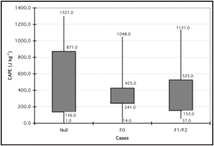
The tornadoes in Iowa today occurred in an environment with sub-500 j/kg MLCAPE and SBCAPE values. At one point SPC mesoanalysis indicated sub-250 j/kg areas still producing low-topped tornadic supercells. Obviously most if not all of this instability was near-ground to maximize the stretching in surface vorticity-rich low levels. While I realize that mesoanalysis is partially model-derived and isn't necessarily gospel, it's the lowest indicated CAPE environment I can remember seeing produce tornadoes. Kholby Martin posted this screenshot on Twitter:

https://twitter.com/StormChaser220/status/803393981719711750

Is there a record for lowest-CAPE tornado events? This one is a contender.

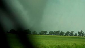
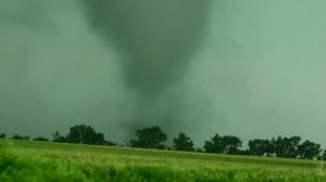
Video of one of the tornadoes:
https://twitter.com/MarkWoodleyKWWL/status/803363750535397376
 
The photos from this event (that I've seen so far), reminded me more of cold air funnels "on steroids" per-say. (EDIT: I hadn't watched the video above yet, that is the most impressive thing I've seen out of this, the further south storms that had tornado reports on them were far far less impressive for what its worth lol). I didn't chase because by the time I saw the potential (around 2 oclock), I figured a 2 hour drive, it would be around dark by the time I got there, so no point in even attempting. But the tornadoes seemed quite brief in nature, what you would expect with a low CAPE and even meager shear environment (~25 knots). SRH wasn't very high either, at least not what you would expect with a "cold-season" tornado event. 0-1km shear was around 30 knots I believe at one point, so that probably made up for the lack of overall bulk shear, still not very impressive environment wise though....
 
These types of days I'll always chase if I can. Fall/winter setups like these (deep surface low north, powerful shortwave, ANY instability down low) seem to have about a 50/50 track record. Today I couldn't easily call off work on short notice. I had to make the go/no-go decision by early morning, and the cloud deck just looked to be too far west for it to have a chance. Otherwise I would have been in northeast MO, probably on the tail end charlie storm west of Hannibal. Short-term models wanted to beef that one up compared to up north, and it was close to home. I doubt I would have ever considered going all the way up north of I-80, as the environment in MO looked sufficient. So in the end, I saved my gas money and PTO, hopefully for something better.
 
Last edited:
Tornadoes can occur with almost zero instability in the traditional sense. Mid level dynamic pressure perturbations in squall lines have produced tornadoes with single digit cape. Remember that static stability is not measured wholey by cape. Ots a parameter. One thats extremely dependent on moisture and temperature no less.

Sent from my SM-G930P using Stormtrack mobile app
 
In the province of Quebec, Canada, we're getting used to chasing these kind of setups. They're far from being easy to forecast compared to classic supercell days.

Actually, I'm saying we're getting used to it, but its more like we hope for it to happen as we get more low cape / good dynamic days. For us it's all about this or OFB-driven storms.

Here's a good example of a tornadic low-topped supercell, as filmed by our team member Allan Theunissen :

At the end he zooms out and you can see the storm structure.

Chasing these setups considerably helped us with marginal risk days in the USA, where you almost can't rely on radar and have to trust your weather knowledge!

Sent from my SM-G925W8 using Stormtrack mobile app
 
Wasn't even looking for a TOR threat yesterday, DMX was able to confirm 4 EF0 tornadoes in their surveys. I chose not to chase the event because I had other things I needed to do and a couple cold core skinny ropes that lasted 1 minute at best just wasn't worth it to me. But an interesting little cold core-esque set up for sure, I was surprised, but given the tornadoes in similar conditions in Nebraska the day before, in hindsight it shouldn't have been 100% unexpected to me since similar conditions existed here.
 
Surprised nobody has made a thread for 11/30/16... I was really expecting a PDS Tornado Watch and I tracked the storms all evening on my Gibson Ridge software. I thought if there was any explosive energy (2000+ j/kg of CAPE) that this afternoon and evening could have been much more volatile. Am I correct in my thinking? I am just starting out forecasting, and I hope I am getting the hang of it. (Tips for future forecasting would also be appriciated!)
 
Back
Top