Dean Baron
Supporter
Starting a discussion thread for the setup in MN on July 8th. The main tornado has officially been rated an EF4 by the NWS- Grand Forks. This is the first EF3 or stronger tornado in MN since 2010. The last EF4 tornado in MN was 8-7-2010, which was in the same general area as Wednesday's tornado. The 8-7-10 tornado was also a slow moving and highly photogenic drill bit tornado, eerily similar to the one on Wednesday.
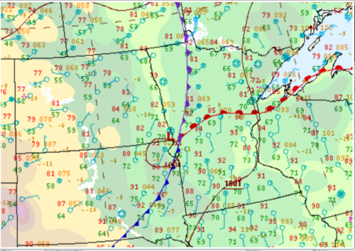
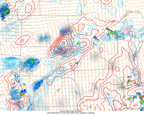
Wednesday's tornado is particularly interesting because it occurred outside (or perhaps on the very edge) of the 2% tornado risk from the SPC. Most of the day the CAMs (especially the HRRR) was firing supercells farther east into central MN. Around the 19z run of the HRRR, a quick shift to the west happened. The SPC introduced an upgrade to a 5% tor probability with their 1630 outlook for the area the CAMs initially showed potential tornadic sups across central MN but these probabilities were not extended west for the 20z outlook, even though most recent model output indicated convective initiation farther west than originally thought. Convective initiation farther west meant storms would be developing in a more favorable environment for tornadoes, as indicated by mesoanalysis and the vorticity shown on the vorticity/0-3km CAPE overlay. This area was also closer to the strongest instability, with SBCAPE AOA 6000 and MLCAPE over 4000. The only question was whether storms would fire in this environment, especially with the 12C H7 temp line nearby, but the CAMs were bullish on CI. An increasingly large and agitated area of cumulus was noted on satellite prior to the storm's development. For those of us chasing, it was not coincidence that most of us ended up on a tornadic storm well away from the SPC's 5% tornado contour. When looking back at the forecast, it shouldn't be surprising that such a tornado occurred when looking at the mesoscale factors that led up to the event. Any other input is appreciated. I have attached a screenshot of the archived 0-3km CAPE/vorticity overlay from mesoanalysis to show how vorticity rich the environment was. Now we know what large amounts of vorticity and extreme instability can do, even in an otherwise seemingly marginal environment.
EDIT: I should note that the tornadic storm is developing on the attached image. This storm also formed at the intersection of the warm front and cold front. This intersection is another reason why convective initiation in this environment should not have been a surprise.
Attachments
Last edited: