Alright I'm going to finally be able to get around to posting about this day; and what a day it turned out to be. I drove to Minnesota not expecting much with
@FalettiWx and walked out with what I believe to be a strong tornado. The NWS rated it an EF-0 without even surveying it; so we will never know the official path length/width, or even the actual strength of the tornado. I find it bad that the NWS wouldn't even survey.
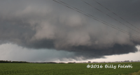
Getting beyond my anger of that I'll start out with the beginning of the day. I woke up at 4:30am to get ready and make the long haul up to our initial target of Montevideo, MN. We had just started approaching the target area when the tornado watch came out, and then proceeded to gun it up US 59 until we got onto the storm, which was displaying some rather incredible structure.
A short while after Billy spotted the tornado as it condensed almost immediately underneath the base, less than 15 minutes of us getting on the storm. It at first appeared multi-vortex, with some pretty incredible motion even at a relative distance.

It also grew rather large fairly quickly.

Here's a couple edited shots to bring out the contrast to show the size of the tornado. Obviously not how it really looked:


Aside from the tornado, this storm displayed some pretty incredible structure. This one had a pretty cool inflow tail.

Some lightning for good measure as well
")

This storm had a variety of cool hues of blue/green as well.

Overall this chase well exceeded my expectations. The mesoscale details worked out in favor to produce this long lived, well structured but very HP storm. This was my first Minnesota tornado, and tornado number 43 in my lifetime book. 2016 has been my best chase year thus far.