2016-05-26 EVENT: TX/OK/KS/NE/CO

Joined
Apr 5, 2010
Messages
223
Location
Omaha, Nebraska
Since no one has jumped under the bus for this forecast, here we go! SPC has most of S NE, Most of KS, and the Panhandles in ENH risk as of the new advisory. They mentioned a bump to Moderate possible tomorrow, which I agree with.

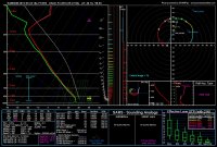
NAM has been really nay-saying Thursday along the warm front in the last few models mainly due to a pull-back on forward motion, but the 4KM is showing some pretty nasty STP's and SCP's along the I-80 corridor south to the KS border starting early, perhaps as early as 1PM tomorrow as CAPE's rocket toward 6000. If everything goes as planned... LCL's will be way below 1000m (seen as low at 400!!!), ESHR is hanging around 40 which isn't bad, SRH's are weak on the large scale, but meso-scale SRH will dominate tomorrow, and take a look at the 250mb jets. Nice nose finally pushing into the area so we'll likely have good divergence aloft and some handy DPVA to act as supercell steroids. Boundary level moisture is good, as the entire area is SOAKED with rain, so as long as we don't get a mid-level mixing-out dry slot or a ton of crapvection, I think we're set for the Northern Target being very chasable. I WILL be chasing tomorrow.

Target: Lincoln, NE around Noon, moving west toward Hastings depending on meso-scale interactions.

Would someone like to offer a forecast for the Southern Target?

PS: as I was cherry picking soundings last night, I found a sounding near Hastings, NE with an STP of 16! and a SCP of 40! The 16 STP was the highest I'd ever seen on a forecast sounding, even higher than Pilger, NE, which was a 14 on the NAM 4KM when I made that forecast back in 2014.
 
I'm tentatively targeting a little further south, i.e. Salina to Russell area. There may not be as many storms further south, but I'd rather go after something isolated. I forsee the warm front being a giant mess.
 
I'm tentatively targeting a little further south, i.e. Salina to Russell area. There may not be as many storms further south, but I'd rather go after something isolated. I forsee the warm front being a giant mess.

I agree. I expect the I-80 and US-34 corridors to be an HP nightmare that's borderline unchasable, but that Nebraska for ya. Nebraska, the land of HP-wedges and dust-tubes.
 
Looking at the 12Z NAM this morning, I was inclined to play the southern target. Looked like a sharper dryline with good convergence in southwestern OK, with a stronger LLJ. The northern target was right on the nose of the LLJ so seemed like stuff would go up all over the place where it intersected the warm front. Also the upper flow looked more meridional in the northern target. (Just read SPC's Day 2 and they actually talked about more of a VBV profile in the southern target so either I interpreted something incorrectly in my analysis or they are favoring a model other than the NAM.) Probably wouldn't matter shear-wise given the easterly surface winds also painted by the NAM, but storms moving quickly to the north off the warm front didn't look appealing. The GFS did not paint as much of a sharp dryline for the southern target, and also veered the 850mb winds more, and it did not show the winds being as backed in the northern target compared to the NAM.

Will probably wait until morning to finalize a target but still inclined toward the south for more isolated storms. Also don't want to be in the position of making the long drive up north for a potentially early initiation.
 
Anyway...I'll be chasing tomorrow. Liking the way things look along the warm frontal boundary which according to 4km NAM looks to lay across Northern KS tomorrow afternoon. It fires supercells in a good environment by 5/6pm...will be good to get back out there after a week of missing tornadoes.
 
Regarding that stupid-crazy sounding pulled from W of Hastings: I wish the CAPE had been over 9000, so I could have made an anime nerd reference. But instead I'll just say wow, that sounding is stupid. How does NAM even think that is physically possible? 120 SCP? 40 STP? 222000 Siv Severe? That hodograph is nearly a perfect circle. THIS IS MADNESS! I've heard of meso-scale SRH's going over 1100, so 900 forecast isn't impossible, but seriously.
 
Today looks like a bust to me. The HRRR has consistently broken out junk in west-central Oklahoma in the late morning hours, which is just going to kill the environment as it moves due north, if that indeed happens. I don't know what is supposed to trigger this crapvection... anyone please enlighten me. This, along with a strange dry punch in SW KS at the same time wipes out the good dewpoints and instability. There could still be tornadoes further north along the warm front, I suppose, but it will probably be a rain-wrapped mess. Not worth the effort, to me. Heck, I may not even chase. But that decision didn't work out well for me yesterday...
 
Insanely moist warm sector shouldn't have problems with crapvection to the south. EPZ 12Z RAOB shows a very strong jet incoming. DDC is showing insanely steep lapse rates and TOP showing great turning. Get all of those together this afternoon and you've got yourself a wedgefest.

I'm targeting around Hays near the dryline bulge multiple models are showing later on. Think today will be huge.
 
Houston we had a problem! Believe the South Texas MCC soaking up the entire moisture return was the main problem. VBV way upstairs was probably secondary for the southern target. Northern target had an issue just below 700 mb, but still produced briefly.

WPC was issuing flooding MDs for South Texas from mid-morning. Midday central Plains convection overturned, but normally the Plains would recover with such deep moisture initially. A large MCC is beyond a typical MCS, and the South Texas MCC was right in the LLJ streamline, so moisture was unable to replenish. Sure the Plains LLJ cranked up and was robust by late afternoon, but it was firing blanks. Evaporative cooling appeared to be a problem in a couple storms we observed.

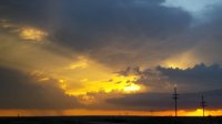
Debacle Thursday was bearable because we saw the entire Dodge City show plus Woodward on Monday. Thursday did offer this lovely Kansas sunset. We were between Bucklin and Medicine Lodge.

Kansas_Sunset1.jpg
 
Back
Top