• While Stormtrack has discontinued its hosting of SpotterNetwork support on the forums, keep in mind that support for SpotterNetwork issues is available by emailing [email protected].

2016-04-28 EVENT: TX/OK

Joined
Mar 30, 2008
Messages
1,488
Location
Norman, OK
Well this day seems to have some merit based upon the 12Z NAM for some surface based supercells around 00Z in Western Oklahoma. Capping concerns and wave timing and moisture seemed to be part of the SPC discussion, but the bullish 12Z NAM does not think so. The GFS seems to mostly be in agreement as well.

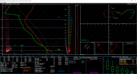
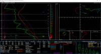
In the NAM scenario a nice sfc low develops near the TX PH/NM border near I-40 and winds back to the east, with a dryline draped just east of I-27. Storms should fire in the late afternoon and move off the dryline into Western Oklahoma where overall the environment looks quote favorable for supercells and possibly tornadoes. Maybe I am missing something here, but here's forecast soundings from Hobart and Shamrock at 00Z and Hobart at 01Z.
f42350a8f1e47cd71d053045973463e5.png

d93b01c14a5e0afdb73fa3ed618fcbfd.png

4a4389a720ea5be0d94a9f0148995ac6.png
 
I see little reason to believe that kind of moisture will actually materialize given how the NAM typically performs (and based on persistence). The NAM is once again basically at the top of the SREF distribution, which suggests dewpoints in the E TX PH will only reach about the mid 50s. Last night's NCAR ensemble suggests even 55 may be a stretch for the Childress area, and it gets drier west of there. Deep layer shear looks good, and perhaps if a boundary sets up further to the east, then LCLs will be a little better, but given the lack of large scale support, storms will only fire along focused surface boundaries, which are progged to be way off to the west in the much poorer moisture.

I just don't see this being much of an event either. Really just depends on if that moisture can get there.
 
Yeah it seems like a dewpoint >60F out there will mean good storms. You pointed out that dewpoints were overforecasted by almost 5F yesterday, so a 62sfc Dewpoint is a go, but a 57F dewpoint is probably not, especially with sfc temperatures near 80F tomorrow.

Seems like a decent day, though, if moisture can actually be realized.
 
The NAM is once again basically at the top of the SREF distribution, which suggests dewpoints in the E TX PH will only reach about the mid 50s. Last night's NCAR ensemble suggests even 55 may be a stretch for the Childress area, and it gets drier west of there.
Hey Jeff, help me with something as I've never chased out there but I've heard mid to upper 40s surface dews out on the Cap Rock is sufficient enough for storms. Is that true?
 
Recent CAM guidance (including HRRR and multiple HRRRX runs) continue to suggest storm initiation by mid to late afternoon. The wind profiles are favorable, but moisture will likely remain on the marginal side. I'm more optimistic about good structure vs. any real tornado threat, but we will see how moisture trends look later today.
 
Back
Top