Randy Jennings
Supporter
- Joined
- May 18, 2013
- Messages
- 855
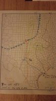
So I sat down tonight and did something I have never done before – I hand drew an analysis of a setup (don’t laugh too hard). It is based on the 20160417 00Z NAM valid at 20160418 00Z (7 PM CDT Sunday 4/17). Except for the surface low, front, and dry line, it isn’t a very typical plot. The orange line is CAPE over 2000. To the west of the black line is SFC-500mb Bulk Sheer > 35 Kts. The green circles are 0-3 SRH > 300 and the blue lines are 0-1 SRH > 100. Until I looked at the other models my target was San Saba, TX as it had a union of all those factors as was a couple of counties east of the dry line. It’s a 3.5 hr drive from the DFW area, and my chase partner and I have been discussing about heading out around lunch time Sunday for a couple of days now. It looked like a good chase day as long as the over night and morning convection don’t mess things up. Then I looked at the GFS. It basically has the low already parked over Central Texas by just after lunch time and the best parameters long gone. Several other models also where aggressive with the moving the low south. We’ll see what tomorrow brings. I’m wishcasting that the NAM is right, but if it looks like the GFS is closer, I’m staying home.


