2016-03-07 EVENT: NE, KS, OK, TX

With last two runs of the NAM, but perhaps with just a little bit of objection from the GFS which has been sticking to its guns for a while...My current thinking is that central or eastern Nebraska may be the target of the day. GFS rains on my parade a bit with a bit less ideal dryline orientation, more back-veering than NAM and overall just less quality values.

So if NAM's rosier picture is to be believed more, storm motions are a touch slower (30kt North, 40kt into OK) while anvil level winds are still in the 55-60kt range with a big bump to 70kt after 0z. That 10kt relative improvement should be enough to keep storms vented, and overall mode/speed certainly a bit more enjoyable. Motion is almost exactly perpendicular to the dryline which is good to see.

But NE's trump card is the closer proximity of the main low, and certainly Hodo's are a looking a little less SSSSSickly than what's showing up in OK. The stronger SRH to the south might be simply lost to that little extra veering we don't really want to see if we don't have to.

But I'm likely wrong. It's March. I'd rather screw up in March than May.
 
We should add KS/NE to do this thread because based off the latest 12z NAM, there may be a target up near the KS/NE border on Monday evening. That is of course, if the NAM is anywhere close to being right. Has a 988mb low in Southwest Nebraska with some upper 50s dew points getting pulled up to the east/northeast of the low. CAPE in this region is fairly generous with forecast soundings showing around 1900 ML CAPE near the KS/NE border with some decent wind profiles. Lapse rates are probably a big driving factor behind the fairly generous MLCAPE values with 0-3km LR of 8.2 C/KM. Another thing I like about this area is its being depicted to have a wider area of instability to work with than further down the dry line. Something to keep an eye on that is for sure.
 
I was wondering a couple of days ago why there was no thread here on Monday's chances.

With the caveat that I have not yet seen the 0z run, I'm liking my backyard's chances... I'm only hoping that things speed up just a bit between now and Monday. As of right now, it is looking like close to dark or after dark before the good dynamics come into play in. Looking at NE FDs, it doesn't look like Hastings NWS has a clue yet about Monday's chances, which could definitely affect their CWA. Maybe I like North Platte's most recent FD because it agrees more with what I'm seeing. If I had to draw a box right now, I'd say Broken Bow to Ord to Red Cloud to Alma (all in Nebraska).

I don't see how we could be looking at HPs in NE because there just isn't going to be that much moisture to work with, but we've got plenty of shear for supercells and nice backing winds with possibly record warm temps (if the feared stratus moves east early enough). I'd just like to see them before dark!
 
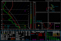
00z 4 km indicating what may arise if we can get lower 60s dewpoints ahead of the dryline in W OK with this sounding near Elk City.

251d6ca9fa86aa676152240f9be67eab.png

Colder than -15˚C at 500 mb and into the mid -40s at 300 mb is nothing to scoff at.
 
00z 4 km indicating what may arise if we can get lower 60s dewpoints ahead of the dryline in W OK with this sounding near Elk City.

Colder than -15˚C at 500 mb and into the mid -40s at 300 mb is nothing to scoff at.

It feels like we've seen this before: the 4 km NAM coming in and showing yet higher moisture content than basically any other model so far. Also, that surface dewpoint value is basically above the top of the SREF distribution of dewpoints from the 21, 03, and 09 SREF runs. No member really goes much above 61, and most members are in the 55-60 range.
 
Reading the forecast discussions, it sounds like the NAM is an outlier, and it is basically the only thing I'm "hanging my hat on" regarding Nebraska chances. Biggest problem will be moisture. QPF shows nothing in the region so not sure where the NAM is getting it from. Feeling less confident that we will see anything good this far north, but I can't be too disappointed if it doesn't pan out. It is only the first week in March.
 
It looks like we're splitting the difference between the NAM and GFS solutions right now. SW/W Oklahoma is sitting in the upper to mid-50s but so is NW TX. The VBV is nasty on the last few runs but if something does manage to form in SW OK tomorrow I'd assume the overall shear profile would at least be enough to get a supercell.

Sent from my XT1080 using Stormtrack mobile app
 
Looks like the HRRR actually has a decent handle on the moisture situation per the last few runs. Almost nailed the 60F line down just south of I20 and advects about a .5 km deep moist layer up to about the Red River. The lead impulse timing is really becoming worrisome though with its center already over the intersection of California, Nevada, and Arizona.
 
Seeing strong indications from CAM forecasts that the temperature of this baby is over 165 F...she's done.

While yesterday's 00Z NCAR ensemble had a few members initiating convection in scattered areas of TX/OK/KS, the 00Z NCAR ensemble is online with the 00Z 4 km NAM and 4 km NSSL WRF (although I think the physics options of the NSSL WRF are basically identical to those of one of the NCAR ensemble members, so really it's part of the NCAR ensemble) in developing no convection along the dryline. Instead, the models want to develop weak convection about 100 miles east, across central OK...although I'm not sure why, as soundings suggest there will be considerable CIN in this area (and these don't appear to be elevated).
 
Last edited:
Two members of the NCAR ensemble initiate convection in far NW OK, but as you mentioned, relatively quiet. However, it does tend to struggle during cool season events and we're not exactly fully transitioned to warm season just yet. Take that for what you will...

That said... I'm rather confused by the SWODY1 outlook. Nearly all the models agree that the environment is way to the W of the I-35 corridor, and I'd say it checks up pretty well against current obs, yet SPC seems to be highlighting what appears to be WAA convection to the E where there is little to no favorable thermodynamic environment.

This event has no guarantees by any means, but if I wanted to see storms tomorrow I'd definitely be out west along that dryline. /shrug.

Also, I thought the NCAR ensemble was only a 00Z run model?
 
Very concerning to me on 12z raobs is capping - 14c at 770mb which seems a little high even in May. FWD and OUN showing great moisture but bad cap. Minimal height falls might not bring that down too much today.

With that said, I still have hope something will break cap later on and that we'll have a nicely structured sup West of OKC metro

Sent from my XT1254 using Stormtrack mobile app
 
We're gonna be shaving it close. Only a few members break precip in western OK but central OK obviously lights up with WAA convection in the early evening. What we're looking like come noon is likely going to be the decider.

Sent from my XT1080 using Stormtrack mobile app
 
HRR continues to pop up some discrete convection on the dl from far NW oklahoma into central kansas within what is atleast a reasonable surface based environment for a weak tor or two... any thoughts on how believable this is
 
Just landed in OKC and not impressed with how cold it is. Stratus deck was quite thick on approach as well. Feels like a typical early season bust.

Sent from my XT1254 using Stormtrack mobile app
 
Back
Top