2015-11-5 EVENT: OK/TX

Taking a look at some of the observed moisture profiles, Im going to go out on a limb ad say that dryline doesnt mix as far east as current guidance shows. Especially if there is limited heating. My money is it is on or just west of the 35 corridor from 20-00z. till not liking it for supercells though. I see messy storms maybe a few QLCS tors.
 
The front is going to push too far ahead of the best dynamics to mini-supercell action going where I had hoped as of yesterday. HRRR and NAM 4KM both push the front into Central MO and E IA pretty fast, and too disjointed from the best dynamics. It's gonna be a QLCS day if anything happens at all. Good Luck November Chasers!
 
Poor lapse rates->very marginal CAPE (and minimal extent)
way too much shear at all depths
weak convergence at the dryline->poor storm coverage (if daytime initiation even happens)

*yawn* Nothing to see here. On to the next trough.


The SPC mentioned limited moisture returns for next week.
 
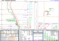
Looking at the 12Z FWD RAOB provides some good insight into the atmosphere this morning. A lot of low level cloud cover, but a little break in North Texas. A strong upper jet overhead with a nicely curved hodograph with a crit angle of 67, which isn't too bad. The closer to 90 the better. Moisture looks to be good today obviously with ongoing cloud cover.

The real weakness I see is the lapse rates being somewhat poor limiting instability with lack of significant heating.

Still think DFW metro and just north could see something nice later on, trying to determine if it's worth heading out after.


That's why there's not much of a hail threat. If there are any tornadoes, they'll be brief QLCS tornadoes, otherwise it's a wind threat with little to no lightning.
 
The front is going to push too far ahead of the best dynamics to mini-supercell action going where I had hoped as of yesterday. HRRR and NAM 4KM both push the front into Central MO and E IA pretty fast, and too disjointed from the best dynamics. It's gonna be a QLCS day if anything happens at all. Good Luck November Chasers!


Yesterday the GFS had some of the stronger upper shear lagging behind the front.
 
Clouds overhead in eastern Iowa are beginning to diverge. Hopefully some sun can poke through today to get things going; it's starting to look likely from my vantage point.

Sent from my SCH-R970 using Tapatalk
 
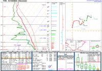
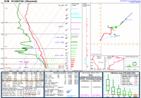
I will say I am a little surprised we didn't see more tornado reports down near DFW today. Plenty of nice little storms, but none of them seemed to drop a tube. The environment depicted on both the 12Z and 00Z FWD raob wasn't too terrible, but the 17Z OUN told the tale for the rest of the warm sector, I think. Straight hodograph launched just before the storms impacted the area, the environment was not very good for tornadoes up north.

2f20ffcbf0d7a28bd657be5bf9832b44.png
af6493c691af22fd010d01b799d92331.png
b910ad0765f715e2999eeb5120c1b248.png
 
I live in Fort Worth and was up the street at a local bar when the cell phones went off with the tornado warning - I was about 5 miles NNE of I-35W and Meacham. It started raining and looking at the trees the wind was about 20 MPH. I checked the NWS radar and yes there seemed to be a hint of a hook on the discrete cell (NWSFW posted some radar shots of that on their site). A bit later I peeked out the west door and looked south and the cell was going to the east of me heading NE. There appeared to be a ragged beaver tail coming off of the storm's back side. And then it was quiet...... Interesting for sure.
 
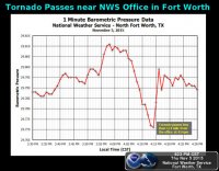
This storm produced a tornado less than 1/4 mile from the NWS FWD WFO. They got some neat data. Didn't need a sticknet for this one. Here is an infograph they posted:
image4.jpg
 
Back
Top