2015-11-5 EVENT: OK/TX

James Gustina

Supporter
Joined
Mar 9, 2010
Messages
671
Location
Dallas, TX
This one kind of came out of left field and so far is all over the place in terms of the overall synoptic setup with relation to the fast moving cold front progged to come out of the Rockies/northern Plains.

Per the GFS, ECMWF and NAM12KM a rather deep, positively-tilted trough is progged to slowly dig out of the Four Corners region starting Wednesday morning. A lead impulse clears the Plains on Wednesday night with a second, stronger impulse and attendant jet streak huff onto the southern Plains late Thursday morning. The biggest concern as of right now is that the relative position of the trough is making it look very likely that low-level winds will be severely veered along the dryline in N TX/SW OK that extends from Hobart down through west of SPS, with modest surface winds out of the south/southeast at ~5 knots.

A strong fetch is already in place across the Plains currently, with dewpoints rising from the upper-40s to the low-60s across southern Oklahoma and northwest Texas as of this morning. While the SW 850s shouldn't notably hamper the moisture situation in the lowest 1km, the large amount of moisture combined with the meh shear profiles looks like it might be pointing to a more multicellular, messy precip convective mode should things stay the same.

With the unseasonably high moisture content going into Thursday, instability looks better than expected, excluding from the NAM4KM which places a very meager instability axis across SW OK. MLCAPE values between 1500 j/kg-2000 j/kg have been showing up consistently now with the GFS and NAM in NW TX near SPS.

The variability in dryline positioning/sharpness along with the cold front's motion is a rather notable problem along with the aforementioned VBV profile due to the trough's angle of approach. However, indications of rather sizable low-level shear have shown up in previous runs and depending on the trough's speed, I still think the possibility for a dryline supercell in N TX is very much alive.
 
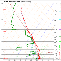
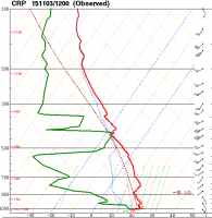
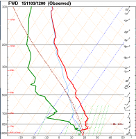
Lets talk about some of the positives for this event. Moisture looks on track! Current obs as of 6pm Tuesday show moisture pooled along the south Texas coast. Dews in the lower to middle 60's are already there. Shallow 60 dewpoints are already creeping up through the Dallas area and into OKC. This is good, one thing you have to really worry about these fall setups is moisture quality. So far, the moist layers are a tad shallow, but unrestricted return flow means that will likely not be an issue. SREF plumes have Lawton OK solidly in the mid 60's by Thursday afternoon.


. Capture.PNG

CaptureCRP.PNG

CaptureDAL.PNG

SREFDEW.PNG
As a result, cape is there, but the degree to which we get any heating is in question. Looking further west, mid level lapse rates are around 6.5-7.5 k/km. Which is okay. Not ideal, but easily enough to get some instability. Temps warming into the low/ mid 70's should provide plenty of buoyancy. Sref has agreement around 500 j/kg I would expect more if any sun gets through.
srefCape.PNG

Another positive or negative depending on your rational is that there is a lot of forcing for ascent. The strong wave to the west will be assuming a neutral tilt by the time it works into the region on Thursday. Speed max looks to be timed well to enter the area on thursday. This means bulk shears are expected to be quite high in the 60-70kts. This is favorable supercell range but low level shear is not as potent. Strong veering in the lowest levels means that hodographs are long and distended with only a small hook. Straight line hodographs tend to favor splitting and linear storms which could mean a mesys storm mode and lots of interactions. To go along with that, strong differential CVA should promote good lift which means that any cap that is present likely wont be an issue but this is a double edged sword. Because lapse rates are not expected to be strong only a weak EML is expected, limiting cap strength. Good ascent with a weak cap could mean everything goes up at once again favoring a messy storm mode.

This will be a fun system to watch, but I have some doubts. We should be within CAM range tonight which may yield a better picture.
 
I was also checking the forecast for Thursday and it was interesting because some models indicated a very weak SBCAPE in the area of 100-500 and other models showed closer to 1000 and that was the same for different models (the two I used were NAM AND GFS)(The program I used was OWX, COD, AND TWISTER DATA) What program are you getting your data from?

Sent from my SM-G900V using Tapatalk
 
System is trending linear and a little short on CAPE looking at NAM. It could bump up a bit, but it isn't going to get the daytime heating now like it would in June. Mid-level winds are looking good though, and if you are close enough to North Central Texas to make a chase attempt, you might as well give it a shot. You might be looking at 6 months before you get another setup like this. Everyone will be begging for a setup like this in January
 
If I'm living in the Dallas Mertoplex, though it's a little rugged and wooded for my liking, I'd be chasing northeast of there tomorrow (somewhere north of I-30). Sure, ongoing precip may spoil the fun, but surface winds are backed, and there is plenty of CAPE for fall and low level shear to get storms going. With those 60-90 + kt H5 winds pushing them, storms should be moving pretty well too.
 
I'll be confined to eastern Kansas Thursday, but I'm not sure that's such a bad thing. Winds actually back ever so slightly in SE KS from 18-00z and you have low-mid 60s dews. The NAM has the morning precip moving out fairly early, but cloud cover will undoubtedly linger. Given how the NAM has performed on recent events, I would bet that it's close to right with 750-1000 j/kg in Kansas, with sfc temps reaching low 70s, but it will all depend on how fast cloud cover dissipates.

There are a lot of concerns with this setup. Winds are mostly unidirectional with some slight veering from sfc-850, and as a result 0-6km wind shear vectors are mostly parallel to the boundary. That combined with linear hodographs lead me to believe any convection will be linear and/or interact with cells nearby. The exceptionally high upper level winds combined with lack of directional shear will have storms racing northeast at 40+ kts. Not really your ideal chase setup, but if something can stay isolated, it definitely has a chance. I'll be keeping an eye on it.
 
If I'm living in the Dallas Mertoplex, though it's a little rugged and wooded for my liking, I'd be chasing northeast of there tomorrow (somewhere north of I-30). Sure, ongoing precip may spoil the fun, but surface winds are backed, and there is plenty of CAPE for fall and low level shear to get storms going. With those 60-90 + kt H5 winds pushing them, storms should be moving pretty well too.
OK, so based on the 12Z run of the NAM, I'd be staying home...
 
Switched shifts to have off Thursday, was really thinking I'd be travelling down to Red river/Dallas area...to at least enjoy some weather before winter fully sets in. But, ever since yesterday I've been scouring everything over and as each model run passes, my attention is drawing more and more towards ks. Luckily for me that would mean I wouldn't have to drive but an hour or two. So with that yes (fuel/distance bias is starting to set in). It would be an after dark event and not as probable.
 
Hate to burst the bubbles of the guys down in TX/OK/KS, but the moisture convergence down there is really lacking all day Thursday. Shear also isn't super impressive. But have no fear, look north! I expect a line of mini-supercells to form from MN down into W IA and into SE Nebraska along a line of very strong moisture convergence, NAM and NAM4k support this. These low tops are likely to only bring small hail, but occasionally this time of year we can muster up a tornado depending on the position of the low and the vort max. Btw, HUGE vort max moving into E NE Thursday afternoon.

It's a conditional setup and reminds me of the Wayne, NE tornadoes of 2013 (which spawned 2 F4's in October!). Any event occurring relies heavily on surface heating ahead of the front, so lingering showers will kill it. If we can get it to 75 tomorrow, which we may, I wouldn't be surprised to see a couple tors along the moisture convergence line from Lincoln, NE toward Storm Lake, IA.
 
Poor lapse rates->very marginal CAPE (and minimal extent)
way too much shear at all depths
weak convergence at the dryline->poor storm coverage (if daytime initiation even happens)

*yawn* Nothing to see here. On to the next trough.
 
Finally took a look today at the 12Z NAM. Plenty of negatives. Mixing ratios are very low, especially once you get into Southern Oklahoma. SW 850s pulling in a bunch of dry air (sub 0C dewpoints) practically all day.

Shear is OK. Lapse rates suck. Yeah, I can't get myself excited to go out tomorrow, even with new tires.
 
Have you guys seen the latest models for the St. Louis area? The models have shown an increase in thunderstorm potential. What are your thoughts on the given models below? I would say that dew point has increased by 10* from what it was earlier and the MUCAPE increased by 500. With a cold front moving through and daytime heating we should get a pretty good lifting mechanism. Screenshot 2015-11-04 at 3.58.16 PM.png Screenshot 2015-11-04 at 3.57.50 PM.png Screenshot 2015-11-04 at 3.57.45 PM.png Screenshot 2015-11-04 at 3.57.35 PM.png Screenshot 2015-11-04 at 3.57.28 PM.png
 
Trough sped up considerably and with cloud cover hanging around all day today I'm feeling like this ends up being that aforementioned multicellular hot-mess express through N TX with how awful the winds look.
 
Correct me if I'm wrong... but shouldn't there be a slight or enh risk for parts of Missouri/Iowa? From what I can tell they have the highest chance of seeing supercell development

Sent from my SCH-R970 using Tapatalk
 
Correct me if I'm wrong... but shouldn't there be a slight or enh risk for parts of Missouri/Iowa? From what I can tell they have the highest chance of seeing supercell development

Sent from my SCH-R970 using Tapatalk

SPC is worried that lack of diabatic heating and moisture is going to limit destabilization. Could go slight later tomorrow, but I am hesitant to say they have the best environment.
 
Back
Top