2015-06-04 EVENT: KS, NE

Joined
Apr 5, 2010
Messages
223
Location
Omaha, Nebraska
Another day with ENH in Nebraska....another possible bust!

This is one of those rare days where GFS and NAM agree on everything it seems....yet I still feel like today isn't going to produce (at least where it should). I don't think I've had a forecast this year where the NAM and GFS were even close on solutions...so today feels odd.

By 00z some extremely sexy 0-3 SRH moves into SC Neb / NC KS. 600+ on NAM... NAM is showing some major rain cooled air at the time, so cape is low / appears capped (but we still get a 3.5 EHI and a 3-4 STP). Based on what happened yesterday, I'm inclined to believe that the stabilization form this morning will make convection hold off until well after peak heating (probably starting around 5-6pm). There will likely be a window from 5pm till about 9pm for tors, possibly sig, if things can get going. After that things will go MCS yet again, with embedded cells possible.

My Baby, NAM 4k (which did terrible yesterday) is showing an area of extreme 0-1 EHI just west of Lincoln, NE by 00z. But I have a hard time trusting it because it's forecasting ongoing precip all day and it often overplays that in meso-scale situations. Other High Res Models show precip ongoing most of the day further south into KS with Nebraska drying out and capping until 5-7pm, at which point we get 5+ STP and things might get crazy.

Again, gonna be one of those feast/famine days it seems.
My Target: Hebron, NE. (But my wife probably won't let me chase).
 
Today has two possible targets, a boundary intersection near the KS/NE border and northeast CO.

Agree with original post re a target in southern Nebraska, perhaps northern Kansas. Morning storms northeast KS spit out an outflow boundary that curves back up into southern Nebraska, or should do so by afternoon. OFB will intersect nearly stationary synoptic boundary in Nebraska and northwest KS. Intersection should be in NE but ouside chance KS. Always worried about cold air undercutting, but 60 to 65 sews north side of synoptic bdry may mitigate such a risk somewhat. Target boundary intersection, following it on sfc and visible satellite before storms start.

Despite the debacle yesterday I believe northeast Colorado is another target. More CAPE will be in place today. Upper winds are lighter but the CAPE could compensate. Hodographs were long yesterday perhaps contributing to the splitting and/or multiple cells yesterday. That shouldn't be a problem today, but again the trade is less upper support. Nothing comes easy in 2015.
 
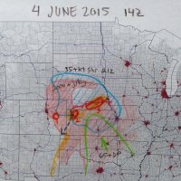
I could be very wrong about this, but I'll be targeting the triple point in northwest Kansas. With MLCAPE approaching 4000 j/kg, bulk shear of 40kt, and 0-1km SRH about on par with the warm front in southern Nebraska (per 12Z NAM), I'm giving it a shot. I'm aware there is some bias due to reduced drive time from my current location in northeast Colorado.

20150604_analysis.jpg
 
I could be very wrong about this, but I'll be targeting the triple point in northwest Kansas. With MLCAPE approaching 4000 j/kg, bulk shear of 40kt, and 0-1km SRH about on par with the warm front in southern Nebraska (per 12Z NAM), I'm giving it a shot. I'm aware there is some bias due to reduced drive time from my current location in northeast Colorado.

View attachment 8483

I've got a feeling your target in NW KS could pay off, there has been a lot of "closer to the low" action this year, but I'm worried about the cap / dryslotting. Also, Bonus Points for colored pencils...
 
The mid-level cloud deck dissipated a good two hours earlier today in Denver versus yesterday. Good daytime heating has been lacking with most setups this year in my neck of the woods, so for a change we have that working for us. The DPs are pretty juicy here with a 58 reading an hour or so ago. The BOU AFD referenced a Denver Cyclone today with initiation in the same basic locations as yesterday, which means I won't have to go far.

I see the 1630Z update was issued by OWS 15 Scott AFB in IL. I wonder what's going on with that - not that it matters - but it isn't super common to see.
 
This isn't a 100% forecast-laced post, but I think it's still an acceptable TA post.

I've noticed with the change in synoptic scale pattern this week, model forecasts initialized later rather than earlier are tending to perform noticeably better. While that's a general rule in NWP, I think it is especially the case this week since we have a lot weaker forcing (less dynamic setups) such that mesoscale and storm scale details make a more significant difference among forecasts. Meso-gamma and storm-scale forecasts for weakly forced events are going to depend even more strongly on accurate ICs compared to forecasts with stronger synoptic scale forcing since a small scale detail (read, error) is less likely to be wiped out by larger-scale influences. Thus, one must be much less trusting of older models like 00Z 4 km NAM, 00Z NSSL WRF, and earlier HRRR runs in favor of 12Z runs or late-morning/early afternoon HRRR runs. Since these storm-scale models are much more aggressive at assimilating current obs (i.e., CAMS assimilate radar and satellite; I don't think the coarser models assimilate them in the same way, and at coarser scales), forecasts initialized later are going to do a better job of representing the true atmospheric state. Also the time period of interest for severe/tornadic storms (i.e., afternoon through early evening) will be at an earlier forecast hour, thus being more likely to verify since there will have been less time for forecast error (IC + model error) to accumulate.

With all that said, if I were chasing I would go almost exclusively on recent HRRR runs. The 14Z-16Z HRRR trend towards two areas with the best chances: SC NE and the eastern part of the DCVZ. The 15Z HRRR had a storm near Hastings late this afternoon with some pretty extreme HMUH values (> 200 m2/s2). It also had a pretty high UH track near Limon at the same time.

In yesterday's forecast discussion thread I mentioned my doubt that the low in SW KS would go. I was wrong since one storm blew up, but it only lived about two hours before it choked on the cap. There was some very strong heating and convergence along that boundary that led to that storm erupting the way it did, which attests to the strength of the cap. The cap looks to be just as strong today, if not stronger. The HRRR blows up lots of storms across W KS today (as does its parent, the RAP), but I think it's overdoing it again, and for the same reasons. It suggests 2-m temps across much of KS will reach the mid-upper 90s with isolated areas breaking 100 F this afternoon. That's because it mixes the PBL way too hard. The 12Z DDC sounding supports temps getting close to 100 IF the atmosphere mixes up to 750 mb. I'm not saying that can't happen, but I doubt it will. Even if it does, it will result in sky-high LCLs. Obviously the more interesting area is to the north, in NE, north of the boundary, where the RAP forecasts 2-m Tds to stay above 70 through the afternoon. Currently they're only in the mid-60s in that area, but upper-60s to near 70 dews are working their way northward on some breezy south winds in KS and OK. However, I'm not sure Tds will stay that high as the PBL mixes out. If it does, I could see a big storm happening in SC NE.
 
Currently sitting a little north of Russel, KS watching a stream of clouds approximately 1km up book north. Judging by the 1 minute refresh satellite its heading up to southern Nebraska, so I may end up playing a little further north.

Little radar blips have begun to show up just west of me, but i'm not convinced that will be robust convection as I can't see much of explosive growth.

Nonetheless, a boundary in place, gravity waves clearly showing up to the east from this mornings MCS, dewpoints in the upper 60s and MLCAPE values of 3000-3500 showing up on mesoanalysis make me think N Central KS.
 
Just saw a tweet from Greg Carbin of the SPC and it looks like the STP on mesoanalysis has a bullseye of 7 almost right where I am sitting.
https://twitter.com/GCarbin/status/606542848373096448

Today really could be a good day if we can get a storm to fire. CU still towering here, but no robust updrafts yet.

CGrfgYPUcAE_65u.png
 
Appears that the towering CU from Hays to Hill City and just north of Russell may become the right moving cell of note on the 18z HRRR. Yes I'd expect turkey towers for a bit, and would keep watching toward the NE border. However NE cells north of stationary front seem uninspiring. Kansas TCU is right on the OFB. Being a little southeast of SF/OFB intersection reduces cool undercut risk, and still plenty of low level shear is present. Kansas TCU may be in the sweet spot.
 
Can anyone offer a post-mortem analysis on this event and why the CO storm was such a prolific tornado producer? My chase trip ended over a week ago so unfortunately I could not chase the event and did not do any analysis on this day (I try to avoid chasing-related stuff the first few weeks after I get back, otherwise I would never be able to get my mind off the Plains and transition back to "real life" - but you would have to live in a dungeon to not have heard about this event!)

I did go back and read the SPC outlooks and mesoscale discussions. While certainly highlighting the area, it seemed a far cry from a sure bet, i.e., not all parameters necessarily at the levels you'd want to see. I especially noticed the mention of "light" upslope winds, although I think I did also see a mention of good low-level shear despite this...

If I were chasing that day, to be honest I think I would have been more tempted to play the triple point, that always seems a more attractive target to me. The CO play seemed to be a secondary target, even judging from the posts here. Did a lot of people actually think the CO target was better, or was it considered a secondary target where the hordes could be avoided?

Ben had a similar question in the advanced chasing forum regarding why the 4th was such a good day in Colorado (and such a bad day in the plains). I think a lot of this comes down to what is still a very raw understanding of vorticity along the front range, and a short history of local climatology. Most chasers have been targeting the plains for decades, but it wasn't until recently that NE CO really has become a hot-bad of chaser activity and study. Jeff Duda had a wonderful post about localized upslope that really sheds light on just how odd things in that area can get.

VORTEX2 spent a lot of time in this area, and my old professor Adam Houston @ UNL spent time in the area flying drones around before tornadic cells formed in order to look at micro and meso scale dynamic conditions. So there is a lot we still don't have right for how to forecast this area with skill, and I'd love to see more research done.

The Simple and Dirty is that we had lots of instability, a little bit o' shear at the right levels, tons of lift (both differential heating based and upslope based) and loads of vorticity, which is often overlooked in tornado forecasts due to our tendency to think along the lines of plains-based storms which often can flourish without a vorticity max.
 
Back
Top