• While Stormtrack has discontinued its hosting of SpotterNetwork support on the forums, keep in mind that support for SpotterNetwork issues is available by emailing [email protected].

2015-05-16 REPORTS: TX, OK, KS, NE, SD, IA, MO,MN

I'd like to add a short report on the Cleo Springs, OK storm, which produced a brief EF-1 tornado. Like a fair number of others, I was far too slow in getting on the road after overnighting in McCook, NE to make it to the Red River valley. I wasn't originally planning on targeting Oklahoma anyway - I had commitments back in central Illinois the next day, so I was hoping to chase in south-central Kansas instead. Unfortunately, I didn't realize until reaching Oakley, KS that the Kansas play had been almost completely wiped out by both the overnight MCS and the morning slug of precipitation that followed. I knew that I couldn't reach the Altus, OK target, but I still wanted to try to catch something, So, I headed to DDC and, with some misgivings, then moved further south into NW OK.

I eventually ended up in Fairview, OK, where I watched the Elmer storm do amazing things on radar. The remnant core of the original Headley, TX supercell was approaching from the southwest, so I decided to wait, catch it and then head for home. Sure enough, it began to get better organized as it approached Fairview, and it soon became SVR-warned. By the time that I got a good view of it from U.S. 60 a few miles southwest of Fairview it was sporting a nice velocity couplet and a tornado warning. Visually, though, it had a long, stretched-out look to it. I took these photos from U.S 60 four miles west of town, and they look either west or northwest:

IMG_2547.JPG

IMG_2551.JPG

IMG_2553.JPG

Here's a final shot of the storm's HP-ish core from U.S. 60 a bit closer to Fairview. The view is to the northwest:

IMG_2572.JPG

I made an effort to keep up with the storm as it produced near Cleo Springs, but I never saw the tornado itself. I called it a day once I got to Ringwood, OK and headed east toward home. I suspect that there were no more than a dozen chasers on this storm!
 
I realize I'm late to the party and don't have much to offer in terms of pictures. What you will see below was taken just west of the gas station in Sweetwater, OK. If you have been there, you will know exactly where I was.

We started the day out heading to SW Kansas but due to the cloud cover in the area and activity in the panhandle of Texas we headed south on 283. I am a noob at this, but here are my first shelf cloud pictures - lol. Drove 605 miles for these. BTW, I am kicking myself for not driving another hour south to Elmer. Ohh, the white car is the Sheriff. He had no problem with me there.
 

Attachments

  • May 16 Sweetwater Shelf 1.jpg
    May 16 Sweetwater Shelf 1.jpg
    93.9 KB · Views: 196
  • May 16 Sweetwater Shelf 2.jpg
    May 16 Sweetwater Shelf 2.jpg
    67.6 KB · Views: 180
  • May 16 Sweetwater Shelf 3.jpg
    May 16 Sweetwater Shelf 3.jpg
    120.5 KB · Views: 187
Started out by driving Friday evening with my friend Matt Bridgewater (out from LA to visit and chase--we'd chased some OH storms last year when we both lived in Bowling Green, OH) from Bryan to Wichita Falls to stay at a Howard Johnson. Got up Sat. and picked the MacDonald's in Vernon to hang out and check radar. As we were about to leave, some hardy chase vehicles also pulled up in the lot. Our first move was after deciding not to pursue storms too far off NW was to go to Quanah area to aim to intercept later activity. We also discovered that our internet connectivity got increasingly worse in the 6/104 area, the GPS icon lagged and popped up in odd places, but the road-viewing got better. I also eventually realized my camera was on EST instead of CST and a +9 minute discrepancy beyond that, so had to correct that with logging everything.

We watched one storm go by at Quanah high school, and then headed East on 287 to pull over and view the next storm that had a wall cloud but couldn't see any rotation. After that, we went south on 6 because we wanted to avoid precip and that was a particularly intriguing storm that was still just severe-warned but looked to be trying to develop a hook. This ended up being the Elton, OK storm. We stopped to watch the wallcloud but on the opposite side of 6 where there was a cluster of chases and a lot of lightning starting to pop. No rotation we could see yet, and we went a little more south and set up again, with less lightning and no rain at all; however, saw clear slot and some rotation which may have been rear-flank downdraft and hook wrapping up. While we were taking pictures Matt's cellphone connection picked up finally, and the storm had gotten tornado warned though that was now to the NE. I had a hope that where we were could become another area of activity wrapping up before our eyes ideally, but unfortunately, once we were south on 6 and watched some degree of rotation and hail cores and the clear slot, we were a bit far back from the real action--looking N. on 6 we were staring at the recorded 3.0 inch hail that apparently fell in Quanah about that time. The last pic here of that storm was at 5:10 PM. In hindsight, we could have aimed to cross the red river but the timing would have been tricky--especially based on the path & particularly to avoid hail damage or not run into the circulation. If we had stayed ahead of it, that would have meant going back north on 6 to east on 287 to 283, or a farmroad to connect. Anyhow, frustrating miss but still some interesting structure. Next time we'll aim to get more familiar with local roads in advance if possible and just stay more ahead of things. Also, included here is a shot to the NE of Wichita Falls that evening because we were driving into the edge of the tor warning & we wondered if that could be the wall cloud dangling what had been the funnel? If anyone has any insights to share on what we're seeing with that Wichita Falls pic as well as where the tornado formed in relation to the Quanah pics, please do get in touch--from what I've heard so far, it was on the other side of all that hail.
 

Attachments

  • at5-10PMQuanahstormhastornadoreportlatera5-30PM.JPG
    at5-10PMQuanahstormhastornadoreportlatera5-30PM.JPG
    146.3 KB · Views: 168
  • possiblewallcloudandfunnelWichitaFallsstorm.jpg
    possiblewallcloudandfunnelWichitaFallsstorm.jpg
    81.3 KB · Views: 174
  • seriouswallcloudonQuanahstorm.png
    seriouswallcloudonQuanahstorm.png
    256.2 KB · Views: 173
  • earlierwallcloudonthatQuanastorm.jpg
    earlierwallcloudonthatQuanastorm.jpg
    175.8 KB · Views: 186
  • Screen Shot 2015-05-16 at 8.07.26 PM.png
    Screen Shot 2015-05-16 at 8.07.26 PM.png
    99.7 KB · Views: 204
  • goingtoheadsouthon62015-05-16 at 4.30.29 PM.png
    goingtoheadsouthon62015-05-16 at 4.30.29 PM.png
    873.6 KB · Views: 199
Throwback I guess. I can't believe I never typed a report up on this one. I edited a bunch of new images from this day, incredible to say the least and probably ranks in my top 10 chases for how close we got, the futuriousity of this particular tornado and the size of hail (larger than softballs). I started the day from chasing tornadoes previously in Nebraska and Wyoming near the WY/NE/CO border unsure if I could make it. I drove south and kept driving and driving and driving until I reached a line of supercells in the Texas Panhandle. It was clear none of the northern storms would do it. I got a glimpse of a rainwrapped stovepipe on the north storm before Elmer, but nothing impressive and never got any good photos or video of that one.

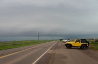
My first glimpse of the Elmer, OK storm was in Northwest TX as it was getting going and then well I'll cut to the chase ;)

DSC_9427.jpg
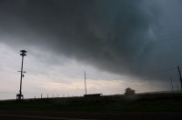
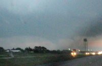
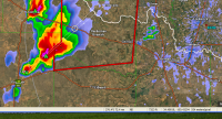
Tornadic supercell W of Quanah, TX. I sat in this spot about 10 minutes and a large tornado developed to the left between the inflow band and the area of precipitation. I originally thought this to be a different tornado than the Elmer, OK EF-3, but later confirmed to be on the ground for nearly an hour so it was the start of that beastly long tracked tornado.

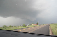
Fast forward to being at the Red River and looking SW and here is a series of photographs I shot:

EF5 wedge.jpg
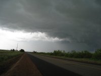
24mm photograph looking SW from the Red River as the strong tornado is crossing the Red River for its second time back into Oklahoma. The roar was incredible here. Likely a combination of the intense/violent tornado and the huge hail coming from my SW in the RFD core.

DSC_9538.jpg
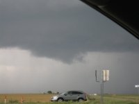
Even wider angle from a bit later, around 20mm F/2.8 on my Nikon D610. Look at that excellent tornadic structure. Wish I had my Sony A7RIII then!!

Elmer, OK Violent Tornado.jpg
Zoomed in shot around 45mm as the tornado was approaching my position very fast like.

Elmer OK Violent Tornado 2.jpg
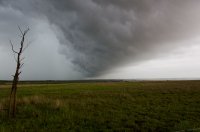
It is crossed the Red River now and has hit something significant as the vortex has turned a dark black and grown in size (not just because it's getting closer, but it is also widening out more).There were a couple small satellite tornadoes spinning up to the right in the streamwise vorticity current as well and being pulled back W/NW toward the main parent vortex.

DSC_9574.jpg
I moved a bit up the road past the bridge and looked back SW and fired a few off at 24mm on the Nikon D610 and I got this. I have a few sharper ones, but I love this one. Here is a sharper one:

Violent Elmer Tornado.jpg

Massive Wedge Low Res.jpg
The monster tornado had now approached my location and was closing in on a mile a way and was over 1 mile wide. I had to leave and now. My route to the S was blocked by extremely large hail and extreme winds over 100 mph. My path to the north? Also rewards me with monster hail and likely intense winds along the SVC, so I take the chances of just going north. Alongside me the tornado constricts into a photogenic barrel-like tornado with helical and horizontal vortices extending way out similar to the Langley, KS Tornado of 2012.

Violent Elmer OK Tornado Close.JPEG
Tornado is now likely between 1/4-1/2 mile away. I can hear the incredible roar and there are numerous power flashes here including a propane tank that explodes. Luckily this area is highly rural and the tornado skimmed by Elmer to the S by just about a mile or so.

DSC_9639.jpg
Tornado has transformed into a multiiple vortex structure before becoming a 1+ mile wide wedge again. I navigated north a bit and tried to get E, but about 2-3 minutes later was my last view as my vehicle was overtaken by a barrage of softball size hail and a wind gust I measured at 105.2 mph from the SW out of the RFD before hail destroyed our anemometer. The chase was almost over. We nabbed another tornado later on in the evening further S and E leaving our count officialy at 3 for the day, but 4 if you include satellites. Either way it was an epic day that I won't soon forget. Luckily the window was easy to repair. I try not to put myself in these positions, but man this was incredible. One of my favorite chase days for sure making it all the way from Wyoming to Texas in less than 12 hours and positioning perfect on a violent caliber tornado....

How did your day fare out?
 
Back
Top