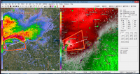
• While Stormtrack has discontinued its hosting of SpotterNetwork support on the forums, keep in mind that support for SpotterNetwork issues is available by emailing [email protected].

2015-05-06 EVENT: TX/OK/KS/NE

No one talking about the mess that's going to occur on the KS/NE border? The latest HRRR's have been showing a mess of high-UD helcity cells forming along the KS/NE border then pushing NE into E Neb through dark, maintaining their UD helicity due to increasing shear overnight. Just enough cape (1500ish) to get things done, DP's in the low to mid 60s. NAM doesn't agree all of that, but it does forecast some serious DPVA aloft, which is always a good sign. Sadly anything up that far is going to be HP-city, and will rely heavily on when the cloud shield burns off. The north target screams 50/50 boom/bust. And low upside on the boom. Staying home...maybe Thursday?
 
The 4km SPC WRF is much more bullish on storms all along the DL. Per mesonet some stations in SW OK are already sitting at 80/70. It looks like the entire warm sector will be getting sunshine within an hour. I will be focusing on moisture convergence and visible sat to see where the bubbling starts.

refd_1000m_f13.gif
 
I'm watching Sean Ramsey footage on it. Definitely struggling to get its act together. Keeps forming and dissipating wall clouds and funnels
 
Wall cloud is damn near riding the ground and moving into deeper moisture again and I have a final in ten minutes. Looks like it might split the difference between Moore and Norman the way it's path keeps wobbling.
 
Watching RadarScope, looks like it is very rapidly cycling between well-organized with a nice couplet to looking disorganized with a weaker couplet.


Sent from my iPhone using Tapatalk
 
Can't believe these TV guys calling out EF ratings by visual references only..... hope people treat it like a real threat..

W.

Was thinking the same thing as I'm watching the coverage. That could condition people to think "it's just an F0 or F1, I don't need to take cover". or that an EF rating can be determined by appearance only.
 
Was thinking the same thing as I'm watching the coverage. That could condition people to think "it's just an F0 or F1, I don't need to take cover". or that an EF rating can be determined by appearance only.

This is totally insane. When did live coverage include minute by minute estimated tornado ratings -- especially when they are rain wrapped? "Gate to gate" shear values can be misleading and are constantly changing. I finally changed to another station's live coverage. They were also calling rotating rain-wrapping curtains large and destructive tornadoes and describing the type of tornadoes based on shear values, e.g., rope, cone, wedge, etc., with no visual confirmations. Insane.

No wonder death rates are rising. I can only imagine how many people are avoiding taking cover because the tornado is "only an EF2 or EF3." This is setting a very dangerous precedent. The NWS needs to nip this in the bud immediately before thousands are killed when the boring EF2 suddenly becomes an EF5 and it's too late to take action. Insane.

W.
Couldn't agree more. Very unprofessional and downright dangerous.
 
Well this was one of the more prolific Plains days in recent years, with multiple targets seeing tornadic supercells and likely several significant tornadoes. Got the rest of the week to go with more potential too. May 2015 is here.
 
Back
Top