• While Stormtrack has discontinued its hosting of SpotterNetwork support on the forums, keep in mind that support for SpotterNetwork issues is available by emailing [email protected].

2015-04-11 EVENT: KS/OK & TX PANHANDLES

Joined
Aug 16, 2009
Messages
814
Location
Amarillo, TX
Ohhh you better believe I'm starting this thread. Although we're all scratching our heads on tomorrow (the 8th), I'm SALIVATING over what Saturday is showing. Classic dryline setup in the panhandles and SW KS. We get some impulses way ahead of a closed low off the SoCal coast. Depending on cap strength, this should help initiate storms off the dryline. The plain and simple is this...sharp dryline along the I-27/287 corridor with 60s TDs, massive dryline buldge south of AMA, 30-40 kt 500s, ~25 kt SEly 850s, ~1500 SBCAPE, and some insane helicity values in the eastern TX panhandle. Capping looks to be the only issue. CIN fills in around 0z, but that might be caused by precip signals in the area. Nevertheless, this looks like a solid setup in my home turf for some massive supercells.

Probably the better news is further down the calendar once that low ejects over the warm sector early next week...but that's for another thread.
 
Been awhile since I started one of these... but hey, I am a sucker for low key events and only a few chasers about!

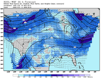
Models gradually increasing confidence of a small event across the High Plains on Saturday. The raging subtropical jet off the Baja ejects a sizeable 50kt shortwave in the late afternoon. Return flow should redevelop quickly in advance of the wave pushing dew points into the 50F range. A dryline will push east into extreme western Kansas by the late afternoon, and will be focus for initial development. A fairly significant cap, 150-200 j/kg, should be in place through the afternoon and limit development to a few isolated storms.

150410-nssl-wrf-wnd5mb35.png

With the increasing moisture 1000-1500 j/kg of long skinny CAPE, more than sufficient shear (60-70kts) with excellent directional shear through the profile, supercells should develop. Tornado potential will be low, but not negligible (especially for a typical western Kansas gustnado, ha) with cooler temperatures in the middle 70s yielding LCL's in the 850mb range - which could be compromised near sunset. If nothing, a well sculpted isolated storm is likely, not to mention a good lightning show with storms developing through the night and eastward. Plan is to head towards Garden City late morning and adjust as any mesoscale features suggest from a possible weak round of storms further south.


Just after sunset Saturday at DDC:

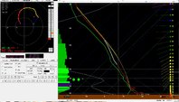
150410-forecast-ddc.jpg

Chip
 
I get off work tomorrow at 4pm, so I'll have to play by ear after I get off. Right now, nothing really crazy jumps out at me. Shear, moisture and CAPE seem decent. I am guessing if cloud cover/instability isn't an issue, the later outlooks might paint a slight risk in the north central portion of the TX Panhandle (I-40 northward) up into the OK Panhandle and into SW KS.
 
Definitely has potential with a lot of downside. With gas as cheap as it is, I might take a trip out to the TX/OK panhandles or even into southwest Kansas.

Moisture is obviously a problem, and the 12Z and 00Z NAM is showing mid 50's to upper 50's dewpoints making it up to the Texas Panhandle. It looks like the influence of a strong low going across the canadian plains is the main driving force behind the return flow, but it doesn't seem completely out of the question looking at the 00Z soundings from Del Rio and Corpus.

It seems like we'll start tomorrow off with some shortwave ridging before developing a little better southwesterly flow at 500mb related to that low/disturbance rolling through northern Mexico. CAPE values should be on the order of 1500-2000 J/KG throughout the day. Could be a good sleeper day for a nice supercell. I fully expect a slight risk upgrade at some point during the day tomorrow if moisture return is anywhere near what NAM depicts.
 
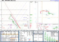
A couple of robust supercells are occurring right now on the high plains -- one NE of AMA and one in far southwestern KS. The thermodynamic environment seems to be the limiting factor for more prolific tornado production, with dewpoints just a little too low. Put a 58 or 60 F dewpoint on this AMA sounding from this evening, and there wouldn't be much one could complain about!20150412_00z_ama_sounding.PNG
 
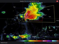
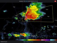
Here are a couple of radar images of the TX PH storm that I happened to save. Nice hook, and I like the way the hail core tightened up and strengthened in the short time between the two scans. It was TOR-warned but velocity couplet did not look all that impressive. Storm seemed to go HP soon after?? There were no TORs from this on the SPC storm reports. But anxious to hear about anyone's experience with this nice isolated supercell in classic chase country, and would love to see pictures, hopefully it had some pretty nice structure?
 

Attachments

  • ImageUploadedByTapatalkHD1428840006.789894.jpg
    ImageUploadedByTapatalkHD1428840006.789894.jpg
    185.1 KB · Views: 164
  • ImageUploadedByTapatalkHD1428840018.124575.jpg
    ImageUploadedByTapatalkHD1428840018.124575.jpg
    186.6 KB · Views: 197
I've created a 7-hour loop of KAMA 0.5° reflectivity, with theta-e contours overlaid, for yesterday's monster TX Panhandle supercell.

loop_20140411.gif


This week, I chased two dryline supercells which moved into relatively stable air (owing to antecedent morning convection) after initiation: the Roger Mills-Dewey Co. storm on Wednesday, and the Channing-Shamrock storm yesterday. It was fascinating to watch how differently they responded to the increasing SBCIN as they each moved eastward. We were all but certain yesterday's cell would begin to dissipate after moving E of AMA, and certainly before reaching Pampa, whose sfc temp may not have breached 70 F all afternoon.
 
Back
Top