• While Stormtrack has discontinued its hosting of SpotterNetwork support on the forums, keep in mind that support for SpotterNetwork issues is available by emailing [email protected].

2015-03-25 EVENT: TX/OK/AR/MO/IL/IN

So I have a question, and I don't mean to call out specific people or teams in a negatively light but I want to see it addressed. On the tornado video of the Sand Springs area from basehunters that has become quite popular on social media, the intro the video states they don't condone hiding under an overpass to ride out a tornado, but it was a "very special set of circumstances" that led them to do just that. But what was the special set of circumstances other than them wanting to catch up to and document a tornado?

I'm guessing that most people who know that you're not supposed to hide from a tornado under an overpass but do so anyway, will explain that it was a "very special set of circumstances". :D
 
The TDWR loop makes it look like a new updraft formed at the triple point of the outflow boundary and RFD gust front from the northern storm. The tornado looks like a supercell tornado, but the NEXRAD data was too coarse to see this. I like how it just latches onto and munches along that outflow boundary.
 
Last edited:
I think in many cases it's simply people trying to get some protection from large hail stones traveling horizontally. When you feel like 2 of your 4 tires left contact with the pavement momentarily due to RFD winds, and you've not spent hundreds of hours in the most horrendous winds, rains, hail, etc as we have, you will look for shelter. It's human nature.

A storm chaser team doing so? I'm not going to comment one way or the other. We've all done things that may have been questionable at one time or another. I think some of the El Reno events (and the tragedy it was) has affected how a lot of us interact with these events, especially in near darkness situations where you're not 100% sure what is where.
 
Here is an image of the 00Z Norman sounding showing how the deviant SE motion of the Moore storm with respect to the Bunker's RM motion nearly doubled the effective SRH and the 0-3km SRH.
toIQc1O.jpg
 
I downloaded the level II KTLX data tonight from the NCDC. Level III is not available yet. I'm don't think I would have issued a warning any sooner either. I just did a quick look at the radial velocity, but there doesn't appear to be a great deal of vertical continuity in the rotation. As the scans go up, the rotation is less defined. My experience in my area, which is covered by the Ft. Worth WFO, is that they will not issue a tornado warning based on a low level rotation radar signature alone. They want spotter conformation or vertical continuity also. If they issued a warning based on low level rotation on radar alone, they would issue a ton of false warnings. I suspect this was the case based on the statement Norman WFO made today: "Our decision to issue a tornado warning was based on spotters and reports relayed by the media. Those reports, combined with an improved radar signature, helped pinpoint the location for the warning." I'll have to look again when the level III data is posted so I can see the storm relative velocity too. The NCDC hasn't posted the TOKC data yet either, and that will be good to look at also. Given the size of this storm and the large area that Norman WFO has to cover, it wouldn't surprise me if they didn't have time to look at TOKC during this storm. We also need to remember this storm was very close to the radar site, and that does effect what we see.

On a side note, they appear to have been running KTLX in SAILS mode, as it has an extra 0.48 scan in it. It's going to be interesting to see this new feature in use this year.

NWS Norman has TVs in their office monitoring local media, and I suspect they saw the local media reports. The power flashes shown on one local channel looked a lot like straight line winds given the width of the damage. The Weather Channel kept calling it straight line winds when showing that clip. I guess we now know that it was a combination of both, but hindsight is always 20-20.

My initial impression is the Norman WFO did a good job. I'm sure they will have lessons learned out of this event, as will those of us in the chaser/spotter community.
 
I'm assuming though that they monitor the KOKC TDWR? I'm not jumping on the critical bandwagon here, far from it - but the reflectivity/velocity signature on the terminal radar was unmistakeable almost immediately. Granted, I don't know how early the actual ground circulation appeared on the chopper cam relative to the very obvious TDWR presentation. It could be the thing was well under way by the time those radar images became so distinct, but it couldn't have been by much.
 
Last edited:
I'm assuming though that they monitor the KOKC TDWR?
I'm sure they do monitor TOKC. Although in a case where there is a long line of storms, the situation is changing rapidly, and reports are coming in over ham radio, NWSchat, TV, phone, website, and social media - things are crazy, and I'm not sure they would have had the time to look at any TDWR site. Maybe they looked at TOKC and it didn't have rotation aloft (I haven't seen all of the data, so I can't speak to that).

I did go pull the warnings from NWSchat . It is clear there was some confusion in the office:

6:41 TOR Warn #1 issued for western Oklohoma county and southeastern Canidian county, lists Moore in text, but polygon stops just south of I-240 and doesn't include Moore (which is in Cleveland county): https://nwschat.weather.gov/vtec/#2015-O-NEW-KOUN-TO-W-0001/USCOMP-N0Q-201503252340

6:43 TOR Warn #2 issued for north central Cleveland county, lists Moore in text: https://nwschat.weather.gov/vtec/#2015-O-NEW-KOUN-TO-W-0002/USCOMP-N0Q-201503252340

6:47 TOR Warn #1 is cancelled. Text says warning was issued erroneously: https://nwschat.weather.gov/vtec/#2015-O-NEW-KOUN-TO-W-0001/USCOMP-N0Q-201503252340

So maybe they miss drew the polygon in the first warning. Or, maybe they misjudged storm movement or looked at an outdated radar paint. Or maybe something else? I will given then credit for realizing the mistake and correcting it in about 2 minutes. I know in my spotting/chasing, I've made mistakes (and it usually takes me longer than 2 minutes to realize it).
 
I did go pull the warnings from NWSchat . It is clear there was some confusion in the office:

6:41 TOR Warn #1 issued for western Oklohoma county and southeastern Canidian county, lists Moore in text, but polygon stops just south of I-240 and doesn't include Moore (which is in Cleveland county): https://nwschat.weather.gov/vtec/#2015-O-NEW-KOUN-TO-W-0001/USCOMP-N0Q-201503252340

So maybe they miss drew the polygon in the first warning. Or, maybe they misjudged storm movement or looked at an outdated radar paint. Or maybe something else? I will given then credit for realizing the mistake and correcting it in about 2 minutes. I know in my spotting/chasing, I've made mistakes (and it usually takes me longer than 2 minutes to realize it).

All I'm going to say is I can see why they initially warned S OKC. Looking at the 2338 UTC scan from KTLX suggests a more obvious and ominous signature there even as the signature is appearing over Moore.

3wKVaum.png
 
Last edited:
Jeff - based on the text (including the SVS which says TOR#1 was not supposed to have been issued) how can you think there wasn't confusion? If they were warning on your "oh crap" feature, I'm not sure the followup SVS would cancel the warning saying it was issued in error...
 
Rob , yeah I misread that. I dramatically changed my post to reflect the more relevant information.
 
Might've been a miscommunication between the person(s) deciding to tornado-warn, and the person(s) whose job it was to project a box and broadcast the warning. I imagine being told "we're warning this storm" and then being shown the reflectivity image above, I would probably notice that LOOK AT ME hook before anything else. I could see it briefly confusing someone; much the way in which you might misspeak when you're thinking about one thing but trying to talk to someone about something else. The words can get crossed.
 
Might've been a miscommunication between the person(s) deciding to tornado-warn, and the person(s) whose job it was to project a box and broadcast the warning.

That's usually the same person so unless he/she has multiple personalities :) Plus the text of the warning said Moore, and I think the person who issued it knows the difference between Moore and west OKC...
 
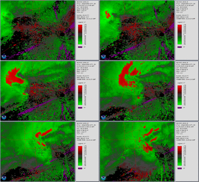
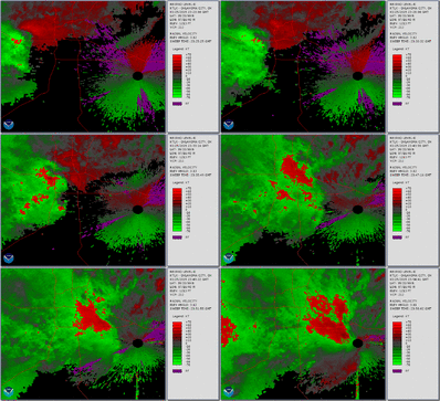
I used NOAA WCT to make a couple of animated GIFs of the KTLX data I downloaded from NCDC. It is ingesting to note the diffs in the lowest angle and the higher angle:

KTLX_RadVel_0_48_small.gif

KTLX_RadVel_3_12_small.gif

I have to say that even though I have the benefit of knowing what happened and I looked at it longer than real time, my eye kept being drawn to the more northern rotation. My guess is that the northern rotation was too broad and not consistent enough vertically to warrant a warning. I also suspect that the reason they didn't warn sooner on the southern rotation was they wanted to see persistence (not to mention - who couldn't help but look at the northern one). I have an animated GIF of the reflectivity, but unless someone wants me to post, I will hold off. I've probably already blew some folks data plans with the 2 above.
 
I've got a question concerning the storm that moved through the El Reno area before it moved into Oklahoma City and produced the Moore tornado. We were on this storm as it moved through El Reno and got incredible pictures of the mesocyclone as it was rapidly spinning as well as some of the "stacked" structure. As we left El Reno, we moved east and, being on a dirt road, had to slow our speed and became overtaken by the storm. I was able to take a quick video in the heat of the moment of the rapid movement of rain bands and dirt being blow violently from right to left of the windshield as we were travelling eastward. I had no clue what this was at first. These fast moving curtains combined with golf ball to tennis ball sized hail hitting the car made for wonder. No, we did not mean to get ourselves in this dangerous of a position. Things just happened very quickly after we stopped for pictures and one thing lead to another. These curtains were not blowing outward (like outflow) but were strongly moving right to left. I looked at the radar and it showed a large hook that almost looked like a backwards J barreling towards us. There was also a tight velocity couplet that was only a couple hundred feet to our northwest (to the left). My theory is that we were on the front side of the RFD and the RFD was perhaps pulling into a tightening velocity couplet. The tornado warning for OKC was issued approximately 20 minutes after the event I encountered happened. I will post pictures and video in the REPORT section, but if anyone has any information on the storm when it was near El Reno and as it progressed towards Oklahoma City, it would be greatly appreciated. I have to apologize for such a short, unorganized post that does not have a lot of detail, but I have been busy at home getting the chase account taken care of and just traveled back from central Oklahoma yesterday and have been busy at home taking care of stuff before school starts back up. Hopefully I can get some help on identification and will have time to write up a more detailed account tomorrow. I am having trouble loading the pictures I was going to show of the radar with our location overlaid, but anyone with information or who can access radar archives I would greatly appreciate their information and input. I was at the corner of SW15th and Banner road at 6:13pm when I shot the video of those bands moving from south to north. It was at this time when the velocity couplet was only a couple hundred feet to our left (northwest) as we were heading east towards OKC. Thank you all for the help and sorry for the lack of presentable data. I am not meaning to post without data, but am merely asking if anyone else noticed the velocity couplet near El Reno, if anyone experienced the event in the area, or if anyone has data and/or speculations as to what I saw or if anyone else saw this. Hopefully I'll have more up tomorrow in the REPORT section. Thank you guys!
 
Back
Top