• While Stormtrack has discontinued its hosting of SpotterNetwork support on the forums, keep in mind that support for SpotterNetwork issues is available by emailing [email protected].

2015-03-25 EVENT: TX/OK/AR/MO/IL/IN

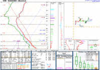
TARGET: OKC First chase of the new year for me ! PROS: Classic set up of a surface low in OK with warm front and dryline. Should be a triple point around OKC around 7 PM. Ample upper winds with short wave should make for some long anvils. CONS: I don't like some of the veered surface winds on some of the forecast models tonight. Also, strato-cu was not very thick over the Dallas area this morning, so the quality of surface moisture is in question (Rich T: Look at the source region !). Expect mostly hailers. Lots of seeding along the warm front will keep me farther west-southwest. Expect to dive south this evening as storms build toward the Red River.
 
The morning stratus and stratocu have mixed out over much of central and south-central Oklahoma, with clouds hanging tough across northern and much of eastern Oklahoma. The morning model forecasts have been a bit better in terms of keeping winds north of the front a little more veered (i.e., from the east) and delaying the backing of the winds (from east to northeast and, eventually, north) a few hours. As a result, the area north of the front across northeastern Oklahoma and perhaps far southeastern KS, southwestern MO, and northwestern AR looks to have favorable wind profiles for a tornadic threat this afternoon. South of the front, the models are a little less consistent in terms of whether the 2m/10m winds will stay out of the south or veer to southwesterly. Current obs show solid 61-63 F Tds across much of the warm sector in OK, which, with abundant insolation at least across central and south-central Oklahoma, will lead to moderate or high CAPE by this afternoon (2000-3000+ j/kg). Dewpoint depressions will be a little suboptimal for a siggy tor threat, but we'll see how the moisture evolves during the day.

As others have noted, there may be a relatively narrow window of an hour or two for a discrete or semi-discrete supercell to develop or mature near the front, before the front barges southward by very late afternoon and into the evening. If the front can lift into far southeastern KS as a warm front this afternoon, that may not be a bad place to be. Another option is near the triple-point, which the latest 15z HRRR has WSW of OKC by late afternoon. The stronger 850 mb flow will reside east of I35, with better shear profiles likely to be located near the longitude of Tulsa and north of the warm front (at least as long as it remains a warm front before it transitions to a cold front). The 12z 4 km NAM lines out the convection in OK pretty quickly by late afternoon, but the recent HRRRs seem to keep some quasi-discrete convection around for a few hours, particularly in central OK with storms that develop near the dryilne. Since I'm in Norman now, my plan is to hang around and see how the front evolves during the early afternoon. If the winds stay easterly near and north of the front, I may hedge northward (that's closer to home anyway). If the winds back to northeasterly north of the front, I'll hang around here longer.
 
What are folks' thoughts on the ongoing convection up in S. Kansas laying down some boundaries and how that might impact some of the plans for later?

The cloud deck here in central Osage Co. has not yet started to thin and it is still chilly, so it will all depend upon what time the stratus clears whether I get a backyard chase or not. My work-schedule inflicted target is the Pawhuska/Bartlesville cooridor.

Best of luck all.
 
The moisture is pretty thin over Texas per the 12z soundings. Models, particularly RAP, are cratering the dewpoints this afternoon...particularly south of the Red River. I put together a quick image of the Fort Worth, Del Rio and Corpus Christi soundings. I'm staying home today even if a nice storm pops up west of Mineral Wells per the latest HRRR. 30F+ dewpoint depressions and resultant high based cold outflow-dominated storms are something I've chased far too much of the past few years. I'll pass :-)

11041734_10205205939580886_6520447715915937907_n.jpg
 
I'm liking the better-than-forecasted surface dewpoints and wasn't disappointed by the 12Z sounding at OUN. Mesoanalysis is showing an area of faster 500mb winds coming into SW OK here around 1230 and water vapor shows the edge of the shortwave entering the western Texas Panhandle. I think timing should be good for a show this afternoon in Central and Southern Oklahoma.

I'm not liking the SW surface winds along I-44, which is where I was initially hoping to target today. It appears all the backed surface winds are east of I-35. Nevertheless, I still am liking the dryline play today.
 
I'm targeting Minco today at the triple point with the RAP nosing 60 dewpoints just south of I-40 at 22z, although as mentioned the surface winds look to be from the SW more often than not. Another concern for me is trying to keep up and navigate rush hour traffic in OKC and not fall behind. Part of me is hoping it develops a bit to the north so I can avoid the immediate metro area.
 
From my ATL armchair....

I like the END- TUL area based on the latest Mesonet obs, temps north of the front are warming up, T-TD spreads are lower up there and the winds are more backed. HRRR has the best UH signal up there as well. Supercells are likely, at least at first, all the way to the Red River, but to me the best tornado chance seems to be NE Oklahoma right now.
 
I'm not 100% sure what to make of what appears to be some impulse crossing Oklahoma as I type this. A notable mid-level cloud deck has formed and pressed east. As it encroached on the OUN/OKC metro, well defined mammatus could be seen underneath it. There is a dramatic wind burst in the mid levels associated with this feature (wind speeds have increased from upper 30s to near 50 kts as per SPC mesoanalyses over the last 2 hours). There is an appearance of some weak lift from this feature on water vapor satellite, but mesoanalyses and vapor satellite show the main trough is still to the west, generally back into central CO and eastern NM, although winds weaken between the OK feature and the trough axis. I'm a little worried this feature will try to initiate convection before the atmosphere is primed and thus result in a less than impressive main show. Also, there could be subsidence behind it, and shear looks to weaken behind it as well.

For those reasons, I think the area near the warm front across N/NE OK and into SW MO is probably the best place to consider for a tornado play. I'm sure storms will fire along the front to the SW across C/SW OK later this afternoon, but I think a combination of large T/Td spreads and weaker shear will result in a non-supercell mode being favored. Also, the cold front will surge southward faster in this area compared to near the warm front. I have been thinking Stillwater all day, despite the poor chase terrain in the area. Something behind trees is better than nothing if you ask me. I'm just not going anywhere near the OKC metro.
 
The moisture situation (and the related LCL situation) is quite a bit worse than the 2m sfc obs suggest according to the 20z OUN special sounding. Lapse rates in the commonly-used layers look great thanks to the warm 2 m T and cold middle troposphere, but "bleh" to the moisture. The storms that developed to the immediate northeast of OKC a couple hours ago have moved up towards Tulsa with some cylonic shear aloft noted with mesocyclones associated with a couple of the storms, but nothing has yet to develop in the "secondary" area where the HRRR had been forecasting CI W or SW of OKC.

The storms in Osage County look well positioned for a low-level mesocyclone threat in the near term, but it may get slammed by cold outflow from the supercell nearing Tulsa soon.
 

Attachments

  • 20150325_20z_OUN_sounding.PNG
    20150325_20z_OUN_sounding.PNG
    94.5 KB · Views: 230
Here is the 6:40PM KOKC reflectivity of the Moore, OK cell showing quite the wrap-up.
 

Attachments

  • march2515okctwdr.jpg
    march2515okctwdr.jpg
    222.5 KB · Views: 235
Velocity looked quite intense as it approached and moved thru Moore. Little concerning is no tornado warning was in effect till after the report of a tornado/strong velocity was indicated.
 
Looks like there was significant damage in Sand Springs. Moore got hit too. I had a friend that lives near Tulsa, he sent me some pictures of the tornado that went through there, it was big! Moore I heard got hit by a weak tornado. It was alarming that they didn't have a warning on it right away. :( 
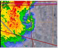
I was watching both of these storms and also the ones in Arkansas on Radar. I wish I could of been out there chasing today. :) Well, I guess the March tornado drought is over now, and Tornado season 2015 has officially started.
 
Did anyone save any velocity images from TOKC as the Moore tornado occurred? I did not get a chance to see them and would be grateful.
 
Back
Top