2011-05-24 REPORTS: OK/KS

I also caught the Canton wedge and Fairview tornado. Originally targeted Enid then drifted north to Cherokee for lunch as i had never been to that part of OK. Visibile imagery showed that initiation was underway further south so I dropped down to the northern cell which had a nice wall cloud by the time I arrived. I had a similar experience as Michael Towers in that I saw nary a chaser for a long time.

QcaNQ.jpg


sebSP.jpg


I watched the merry-go-round form then snuck south for a better view. This was easily the strongest tornado I had ever seen and was frankly astonished by how quickly it grew into a stout wedge. The experience for me was completed by hearing Roger Hill exclaim "Violent Tornado !" from behind me :)

JTPdc.jpg


I followed the storm which cycled and produced the beautiful Fairview rope.

xNn0u.jpg


At this point I considered dropping south to the storms crossing I-40 but I'm not comfortable chasing in more populated areas so I elected to head east and try to intercept the Guthrie storm near Stillwater. I arrived at a nice elevated spot about 4 miles south of Stillwater on 177 ahead of the circulation and attempted to peer west. I stayed until I detected some rotating rain bands and then bailed east. When I returned I passed through a light damage path about 1/4 north of my initial position. Headed back to Wichita for a celebratory burger and beer.
 
Canton/Fairview Tornadoes

FULL CHASE REPORT WITH IMAGES AND VIDEO HERE.

TWISTEX and myself intercepted three tornadoes with my crew seeing two of them near Canton and Fairview. The Canton tornado we measured from its birth til it moved out of range over the lake thanks to the dam road being out.

20110524vid_14.jpg


20110524dash_01.jpg


20110524dash_06.jpg


After losing the Canton tornado, we ventured up to Fairview where I intercepted career tornado #200.

20110524_03.jpg
 
Last edited:
Late report since I had to get approved before I could post here.

Had great position on the Canton tornado on a hill that allowed for an unobstructed view of the tornado from the moment it touched down till we lost it in the rain. The day also reminded me Oklahoma has the most overrated terrain of any state out there.

After the Canton tornado we dropped south and caught the monster wedge north of Piedmont, called off chase when we arrived upon major damage to assist with search and rescue.

Full log: http://www.chicagoillinoisstormchaser.com/052411-May-24-2011-Oklahoma-Tornado-Outbreak.php

DSC02857.JPG


20110524173019%25281%2529.JPG
 
SHORT: A spectacular day for the Marshall crew. We filmed tornadoes at Canton (3:19-3:39 pm) and Fairview (3:47-3:51 pm) in northwest Oklahoma.

LONG: I picked ENID as the target town and our group (consisting of several V2 people) had lunch there before proceeding west to the dryline. Enroute, a supercell developed near Elk City and moved rapidly northeast. I chose Canton as the place to meet the storm. We arrived in Canton at 3 pm, and observed a ragged cloud base with wall cloud and northward pointing tail to our west. A rain-filled RFD soon cut into the updraft from our south and began wrapping the circulation. Cloud base rotation rapidly increased to the point where a funnel developed just to our west over Highway 51 at 3:17pm. We stopped 1.5 miles west of Canton and watched a high-contrast, multi-vortex tornado form immediately to our northwest at 3:19pm. The tornado took several minutes before filling in and became cone-shaped with large dirt/debris bowl. We followed the tornado north on Highway 58A (past the LUCKY STAR casino) at 3:26pm where it continued to enlarge to a large truncated cone. The tornado then crossed Canton Lake becoming rain wrapped. We crossed the dam and saw a spectacular tornado wave (tatsumaki tsunami) heading for the east shore. The tornado then narrowed to an elevated cone east of the lake before dissipating around 3:39pm. We continued north on Rt. 58 and stopped a few miles south of Fairview. We watched a clear slot begin cutting into the wall cloud at 3:42pm. Within minutes, a portion of the back edge of the updraft became occluded and a high-contrast, ropy tornado formed to our west-northwest at 3:47. The tornado elongated into a stretched-out rope and dissipated at 3:51pm.

We continued east on Rt. 60 through Enid and intercepted a rain-wrapped circulation just east of Stillwater on Highway 51. Suddenly, strong winds hit us and branches and shingles began flying from the south. Realizing, we were too close, we abandoned our location (along with a Oklahoma Highway Patrol vehicle) and headed east on Highway 51 when a close lightning bolt struck repeatedly just south of the highway next to our vehicle. We broke off the chase and proceeded to Joplin to conduct a damage survey the next day. A great chase day, although the tornadoes were moving fast.
 
I was originally about 5 miles North of El Reno and waited about 10 minutes for the tornado to come to me and it appeared it was gonna go just South of me so i went about 2 miles further South and waited. Within about 7-10 minutes a "wall" starting getting very close. Got some amazing inflow and saw lots of power flashes as it was crossing the road. A few moments out of nowhere a stovepipe appears and sends a whole fleet of chasers running for their lives. I was pretty sure i was ok where i was at but seeing people coming almost right at me-some in reverse, got the best of me and i hauled but to keep from getting hit by them or the tornado. Everybody thought it had passed including myself and we got a major surprise. It threw a semi in the ditch and leveled a 2 story house as it-they, crossed the road. Some chasers got out to help him and it "appeared" as if it was coming back and alot of them went running back to their cars. I checked on a school that people was pouring out of and also a small subdivision down the road. I was almost shaking from fear it was going to be another Joplin scene, but thankfully the people i seen was just shaken up. Here is a copy and paster from the public information statement showing a upgrade to EF5...PRELIMINARY DATA...EVENT DATE: MAY 24, 2011EVENT TYPE: TORNADOEF RATING: EF-5ESTIMATED PEAK WINDS (MPH): GREATER THAN 210 MPHINJURIES/FATALITIES: UNKNOWN/9EVENT START LOCATION AND TIME: 8 WNW BINGER 3:30 PM CDTEVENT END LOCATION AND TIME: 4 NE GUTHRIE 5:35 PM CDTDAMAGE PATH LENGTH (IN MILES): 75 MILESDAMAGE WIDTH: UNKNOWNNOTE: RATING BASED ON UNIVERSITY OF OKLAHOMA MOBILE DOPPLER RADARMEASUREMENTS.
Link to my footage from the dashcam..http://www.youtube.com/watch?v=hJmtzzfVqeQ. You can see the tire on the side of the road in front of me start to move. I have to give props to my chase partner Kayla Branham. She is a intern for the news station i chase for and in the Joplin and this encounter, she keeps her cool.
 
Last edited by a moderator:
Sorry for the late report.. but I did chase this day which was almost unfortunate being as close the tornado came to my farm. Matt and Michael Starkey, Mark McGowen and myself initially left the house a little after 1500cdt. Had initially targeted cells that were firing up near Binger.. I figured these had the best chance of going SVR and that it did in short order. Went To Okarche, then south to El Reno when the storm was putting down the initial tornado below Calumet as it raced toward the interstate. By the time it was reaching the interstate, we were sitting at the last El Reno exit west bound and eyeballing an incredibly immense wicked looking HP supercell and a rain free base that was just to the south of I-40 some 8 miles to the west. I was not about to go any further west as we thought we would catch a good glimpse of the tornado from where we were at... but that was not be, it was just too enshrouded in rain from our location and the positive staccato bolts were unusually frequent and intense.. we elected to go back east on I-40 bucking a 40-50 mph inflow as we passed back into El Reno. Knowing it was crossing the interstate and moving northeast from Calumet.. I did the math and plotted the direction... not good , at all. I figured it would be going right through Piedmont in about 30 minutes. I decided to head back to Piedmont. we got to Piedmont Rd. and Wilshire.. the police had it blocked off. We headed east and by the time I got to Council.. I had a phone call from my son Leif.. they were at the shelter, he said it looked liked it was coming right at us.. "This doesn't look good dad" he said with a shaky voice.. "I think we're going to get this one .. I love you dad, I love you very much" before I could hardly respond, he hung up. Haunting memories from May 3rd '99 came roaring back.. but this time, I knew my family was safe, but once again, for what has seemed like the 5th or 6th time since we have moved here to Oklahoma in '96. I felt like a bullseye on mother nature's dart board and that we were about to be reduced to a grease spot on the prairie. After two phone calls from different chasers, conveying lots of concern for my family and farm, one of which actually said "I think your place just got hit" I hit a low point in my day (maybe my life) Thank God for my friends that were with me.. I was not dealing with the situation too well.. but finally a little after 1700cdt, I got a phone call, caller i.d said "Leif" okay I thought.. I'm man enough to handle this.. knowing he and my wife were probably alright but the house was gone.. "you okay??" as it seemed like my whole body was trembling in anticipation of the response.. about a 3 second pause before he echoed.. "we're all fine... the house is fine, it missed us" Have you ever laughed and cried at the same time?? That was me. We finally made it back to the house via some back roads, chills came over me in waves as I saw just how close the whirling dervish nearly took my farm and my whole neighbourhood with it. Instead, it jogged a few degrees to the right, bringing the core of the tornado literally yards from missing the main neighbourhood that has about 70 homes altogether. Had it maintained the course it was on, it would have been a far worse tragedy to say the least.

After knowing Dee and Leif were okay.. we decided to try and intercept other cells that we figured would track up toward Chandler and Stroud, but by this time, the increase in forward speed of the cells that probably would have taken us almost to Tulsa and with dusk coming on.. we bailed on the chase at Jones and started back. I did shoot some video, no pictures though.. video was relatively uneventful as there was only the commotion you heard from the media and my increasing concern for my family/farm. I hardly shot any video once I knew we were in peril.. I even turned off the radio, didn't want to hear the play by play of the destruction of my community. It's been almost two weeks.. the scars remain all too vivid, and probably will for years.. a beautiful farm just southeast of me by about 2/3 mile was leveled.. easily EF-4 damage.. I cringe passing by that on my way to work every day.. knowing that could have been our place.. I pray for all who were affected by this storm.. for the family who lost two of their children.. we didn't know them personally but know their relatives who attend our church. Please remember these folks and all others affected. Meanwhile, life goes on here in the heartland.. Thanks again for all the inquiries, thoughts and prayers concerning my family and farm.. you all are the best!
 
Firstly, apologies for the delayed report. Had issues getting the ST account going again.
However, better late than never.

Below are a few images and video from the Chickasha, OK Tornado on the 24th May 2011

The clip shows most of the lifecycle - Wall Cloud to Wedge - in about 13 minutes.

0018_IMG_4708_processed.jpg


0024_IMG_4726_processed.jpg


0031_IMG_4741_processed.jpg


Watch video >

Daniel Shaw
www.severestorms.com.au
 
Last edited by a moderator:
This is a late report because I had to get back to France first, then edit my video and then wait for being able to post here but I can now share with you this french point of view of the Shawnee tornado. We were 3 french guys spending 4 weeks in the Tornado Alley this year. We chased this high risk day starting by the Canton cell in Oklahoma. Unfortunately we didn't see the first tornado because we lost data connexion just a few minutes before it touched down and also lost the view of the meso.
We then decided to go for the southern cell which was heading towards El Reno with an impressive velocity signature. We saw the EF5 rain-wrapped tornado cross the road 74 in front of us near Cashion. We wen't through massive damages and sadly it seemed there was a few farms which had been hit by the Tornado. As several cars were already there to provide assistance and we couldn't go further because of down power lines we drove carefully to Oklahoma City and then took the I40 heading east. That's where the following video takes place.

Watch video >

I hope you can understand me quite well!
 
Last edited by a moderator:
Intercepted the Fairview, OK rope and later the Shawnee, OK tornado at close range with Dustin Wilcox and Brian Stertz, by now there isnt much to say that hasn't already been said so I'll just post some images, just got my target area privledges back:

Inital funnel when we got on the storm just East of Fairview:
5797901983_bda75cee81.jpg


Turned into this rope:
5798457336_954f54ff54.jpg


We made it south, with debris falling from the sky near Guthrie (which was quite surreal) to the Shawnee tornado just as it crossed the interstate...

Wide Shot:
5792026325_d92e27caae.jpg


Another wide shot shortly before roping out:
5807031720_46bcee04fd.jpg


Zoomed in as the tornado crossed I-40:
5810551284_87673e4291.jpg
 
Started the day at the house in Russell, KS where I had chased central OK the day before. Today I would end up in almost the same areas except that today was the day that the upper level trough was coming in in earnest and a high risk for severe weather had been issued by the SPC.

I left Russell, KS about 11am CDT and proceeded straight south through Pratt and into OK and down just west of Alva, OK when the first tornado watch was issued. It was a PDS watch for Particularly Dangerous Situation.

I could see on visible satellite that a CU field was building just to my south and 3 cells quickly formed on the western edge of the CU field. I was in perfect position to intercept the northern one and so I went after it.

I caught up to it just west of Canton, OK and followed it's updraft for quite awhile while it got organized.

Just south of Canton Lake, OK a wallcloud formed and began to spin strongly. I knew that it wouldn't be long before this storm tornadoed.

The rotation area headed north east and I opted to take the north option that I was on right there and not try to get further east. This proved crucial to my excellent positioning!

As I shot north the line of trees kept blocking my view of the developing tornado but I could hear it spooling up like a jet engine at the airport. A sound I will never forget!

I found a few breaks in the trees and could see the monster going laminar and touching the ground now. I could also tell that it was vectoring and would cross my road very soon. As soon as I saw it break the line of trees I hit the accelerator, turned off the wipers and let the video tape roll!

What a tornado and it was right in front of me and no one else was around. They had all gotten one county road east and would not have the unique white rope view that mother nature would show only to me.

Tree branches and leaves were swirling all around in and over my car as I kept the window down the entire time to get the full sound experience. The rushing wind and jet engine sound was almost as memorable as the visual treat of the widening and multivortex cone that was now to the east of my road.

I quickly reached where the tornado had crossed the road and it was completely blocked by numerous downed cottonwood trees and the powerline. I turned right up a field access road but it was blocked by a large root ball that had been dropped there.

I quickly jumped out and began to run towards it with video in hand. The RFD wind was incredible and I thought I was going to break an ankle as it propelled me over a cattle guard that I was sure I was going to fall inbetween and break a leg in. The tornado was still only 100 yards away and completely denuding the grove of trees in from of me. I watched as it stripped 50 foot high cottonwoods to 10 foot tall stumps!

The tornado then began to widen and take on a look of the Tuscaloosa, AL tornado that we had all seen from the month earlier. The seething updrafts of white rotating around the dirt swirls were strong, violent and relentless.

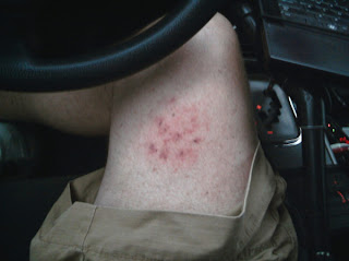
I knew my chase was over. No roads to get through, no way to keep up on foot without getting miles from the car and so I contemplated my next move as I videoed. I didn't think about the first piece of ice that rocketed in next to me. You can see it at the end of my video busting up as it hits the ground. The next winddriven softball hailstone flew over my head and into the field. I realized the danger and turned to run back to the car when *whack* the next one hit me right in the inner right thigh! I thought 'oh ' and ran back to the car with my hands over my head and hunched down thinking the next one was going to hit me in the head and kill http://www.blogger.com/img/blank.gifmhttp://www.blogger.com/img/blank.gife. This scared me more than the tornado - these I could not see and were like cannon fire from the heavens.

This tornado was rated an EF-3 and was my best intercept of my life to date. The tornado went on to be visually the strongest over Canton Lake where a higher rating would be impossible. I have not heard of any injuries or fatalities to date with this tornado thankfully. Later tornadoes south that I could not reach went on to do much damage in and around OKC.

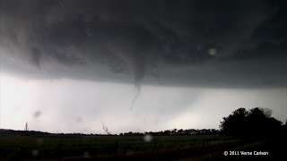
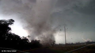
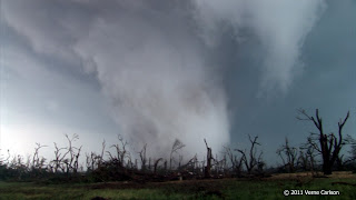
20110524_CantonOK_02.jpg


20110524_CantonOK_09.jpg


20110524_CantonOK_16.jpg


20110524_SoftballHailBruise.jpg


This is my leg moments after getting hit with one of the softballs in the RFD!


Attachments

  • 20110524_CantonOK_02.jpg
    20110524_CantonOK_02.jpg
    9.8 KB · Views: 35
Last edited by a moderator:
This is long overdue... I've (finally) converted and made available tornado/storm chasing videos from years past and posted them on the Videos page on my website at www.springwx.com. There are several videos available for viewing...and I'm adding more as I find archived storm chase videos in my collection.

The video available for this date is titled Lookeba, OK Tornado:
May 24, 2011: After 2 days of volunteer work with the clean-up efforts in the wake of the EF5 tornado that struck Joplin, MO, I raced west to catch this tornado in west-central OK. Unfortunately, the road network in that area only allowed me to catch this short video as it crossed the road in front of me. The 3/4 mile tornado was rated EF3.
 
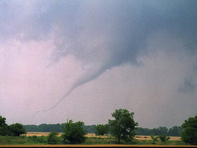
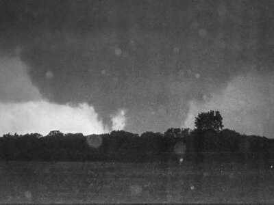
Remembering Oklahoma from more than a dozen years ago with a couple of my photos. Here we have beauty and the beast, the Fairview tornado roping out and the Canton Lake wedge, respectively. The Japanese like to say, "Wabi-sabi," or find joy & beauty in things that are less than perfect, objects that have grown old, perhaps developed a patina, or have character, whether it's objects or even people.
9825_11B.jpg9825_09bw.jpg
 
Last edited:
Back
Top