• A friendly and periodic reminder of the rules we use for fostering high SNR and quality conversation and interaction at Stormtrack: Forum rules

    P.S. - Nothing specific happened to prompt this message! No one is in trouble, there are no flame wars in effect, nor any inappropriate conversation ongoing. This is being posted sitewide as a casual refresher.

2011-05-24 REPORTS: OK/KS

Fell behind the storm that produced the reported wedge near Canton, OK. Kept dropping south, while coming across some extensive damage. Also saw smoke on the horizon :-(. After getting back in position caught the tornado below near Shawnee. Haven't gotten to my hotel yet. Will write more soon.

tor2_52411.jpg


tor1_52411.jpg


hail.jpg


Some more comments on blog...
 
Last edited by a moderator:
After a very frustrating mid/late afternoon in the southern portion of the High Risk (SC OKLA), storms finally got organized in N TX and tracked through Love/Carter Counties with Tornado Warnings. We got on the cell that tracked just east of Ardmore through Dickson, where it developed a monster wallcloud with strong rotation, but no tornadoes. We hung with it up HWY 1 into Ravia, where it seemed to re-organize a couple times with no success again. As that storm moved off, a new Tornado Warned storm was moving into the Ravia/Tishamingo area that had a pretty healthy notch on radar just NW of Ravia, so we drove 2 miles north and finally saw a real deal low wallcloud that was certainly organizing fast. The wallcloud was almost scraping the tree tops when it finally wrapped up and multiple vorties started touching down. We were within 100 yards as it really intensified crossing the road south of us and got rain wrapped with insanely fast rotating rain curtains! Fortunately it stayed just north of Ravia, so the main portion of the town was spared, though there may have been some out lying homes damaged, as we saw several emergency vehicles heading into the tornado affected area about 10 minutes later. All in all, nothing like what happened up in the metro areas, but one helluva big tornado that ended all of the earlier frustration in Southern Oklahoma ;)

S1170010.jpg

S1170016.jpg

S1170021.jpg

S1170031.jpg


* Short Video Clip of Violent Rotation as the Tornado became Rain Wrapped from Super Close Range!

http://www.youtube.com/user/FirstIntercept1972?feature=mhee
 
Last edited by a moderator:
Started from Watonga and targeted Binger. Positioning just south of Binger, caught the tornado at initiation that was just south of Hinton. Notified 9-1-1. Chased as best as possible from that point spending most of the time lingering in RFD repositioning. Finally dropped south and east to Minco to intercept Chickasha only to have another RFD-into-tornadic debris experience on US 4 and I-44.

Seeing massive debris at that exact intersection Robert Balogh and I experienced deja vu, and made the decision to end the chase and respond. We didn't have far to go before we came in contact with the incident commander for Grady Cty. I checked in with him which eventually merged into me being the chief of medical operations for Grady and McClain county multicasualty response (underneath the overpass at US 4 and I-44).

I expected another Joplin experience. I was terrified of it in fact. But fortunately, this time, no fatalities, only one moderately injured woman, and walking wounded. This time, everyone locally had taken shelter and heeded the storm. Kudos undoubtedly goes to the SPC and radio/TV around OK. There was absolutely no question of peoples' lead time on this one. In addition to the HIGH risk, people took shelter.

Early on, though, it wasn't clear what we'd encounter. So when nurses showed up at the incident command, we set up for triage. Given our previous experience, we had talked about the weaknesses, but largely the effectiveness, of the response in Joplin. We attempted to set up road-side what we saw worked so well in Joplin. In no time, we had a small area with a tarp, nurses, trauma equipment, and a gameplan. We interfaced exceptionally well with the emergency teams, and the coordination improved rapidly. Robert Balogh (who happens to work in Lawton) contacted his colleagues at local area hospitals. I called the ERs at Norman and Southwest hospitals. Norman requested divert status if possible, Southwest was open for anything we could send.

It was a surreal experience. Having been through Joplin, I really felt oddly prepared and calm. And ultimately, little aid needed rendering. In fact, I was totally amazed by how rapidly the county FD and SO had so completely dissected the most of Bridge Creek and surrounding areas, had accounted for nearly everyone (not just once, but twice over), and could safely state that there was little reasonable chance of further injuries or fatalities before midnight.

Suddenly, what had shaped up to be a massive two countywide multicasualty incident, was over, with my paperwork showing only about 10 injured. We waited until the response was officially transitioned from search/recovery to mop-up and the incident was declared complete.

I've spent whole years chasing with nothing to chase during my two week trip. This year, I can hardly begin to understand the events of only the past 48 hours. This "anti-casualty" mass casualty incident today left me feeling hope where Joplin left me stricken. Once again I was humbled beyond words by the contributions of every single person who could offer their help and did so, officially or not, even when their families' fates were still not known. That the hospital system was not overwhelmed, that we had good cell coverage, that OKC and I-35 cities were largely unaffected, and that the incident was suddenly over without us having to leave behind masses of new patients, made all the difference. Oh, and we also had assistance by John Hansen, the former chief of OKC's fire dept who was lead on the OKC bombing and assisted at Hurricane Katrina and 9/11, co-coordinating fire incident command. Indeed, we (and all of the residents) were well prepared.

So, in summ, we had a good chase strategy, we saw a large tornado, and we helped out (but weren't needed). It's been an incredible day beyond words.
 
Caught the Canton tornado and then the Fairview rope... what a great day! Due to terrible internet connection problems (Millenicom), I missed the timing to drop south to OKC sups. Here are some pics...

24_05_2011mk1.jpg


24_05_2011mk2.jpg


24_05_2011mk3.jpg


24_05_2011mk4.jpg


-Marko
 
I'll post a more detailed report later. I had a close intercept with the wedge that formed near Hinton and again with the wedge from Ereno. Contrast on the wedges was poor due to wrapping rain curtains. I also saw the beautiful Shawnee area tornado that crossed the interstate.

YouTube video of the Shawnee area tornado.

http://www.youtube.com/watch?v=6i-5sIvsD8c

Full Chase Report (added Dec 2011)

http://www.harkphoto.com/05242011.html


Bill Hark
 
Last edited by a moderator:
Fritz Kruse and Jon Finch and I chased the triple point area around Otis. We dropped south to hwy 96 and saw 3 tornados from around 515 to 535 pm near Timken KS. The first tornado was a narrow tornado that lasted about a minute southwest of Timken, followed by a cone tornado, then a wedge tornado northwest of Timken. We were about a mile from the wedge tornado and could hear a roar. Here is some video of tornado number 2 and 3. The wedge is low contrast.

Watch video >

Watch video >
 
Last edited by a moderator:
A short post to clarify and expand slightly on what Jason Persoff posted above, with a pic of the Binger tornado included. The pic is nothing for National Geographic and totally unprocessed, but does portray what we saw

Started the day in Watonga and after being convinced by Jason that up near the triple point was NOT the best option for the day, finalkly started moving south after the first cells began to go up. Got into great position right in the inflow notch on a cell just south of Binger and then saw it tornado for the first time just north and west of that town (after a sudden Dukes of Hazzard moment on a bridge on a dirt road).

036.jpg


When we got back to Hway 281 north of Binger, found it cut off by a downed power line, so we dropped back to 152 and headed east to 81 and then north. From El Reno we took old 66 to Yukon, and while listening to the sirens going off in Yukon was having horrific visions of a)the prospect of how to get thru, much less chase thru, the OKC metro, and b)the death and destruction from a direct hit on the metro. The latter only got worse a little later as we were behind the storm that had hit Newcastle and was headed for Moore, listening to FM94.7 as the prospect of direct hits on OKC and/or Moore and/or Norman looked possible.

Shortly after hearing that there was no tornado on the ground in Moore and that Norman appeared ok we came across the debris trail that Jason described - it was actually at the junction of Hway 4 and the Norman Spur, not I-44.

The next few hours were quite surreal. Not only were we "doing it again" for the second time in three days, but two of the nurses who showed up were people I work with and know. In contrast to Joplin, where despite grinding on and trying to stay in the moment I couldnt help but feel overwhelmed in a way, this time I felt ready and on top of things. Of course, the far fewer and far less serious injuries contributed to that, but being a "veteran" was also a big help and reassurance.

Kudos to all who aided in the relief efforts yesterday, and our location and all the others as well. The Blanchard Ok fire and police depts in particular deserve praise, but really it was just a magnificant and well-run group effort. Truly inspiring

In the end, I think it's going to be quite some time before I truly have a chance to process the events of the past few days. In the space of a week of chasing I have seen all of about two minutes of tornado, but this will still be a chase "vacation" that will be forever etched in my mind. From an apparently suicidal deer, to Jason throwing handfuls of change at a nonfunctioning toll booth to facing and working thru the nightmarish twice in three days - just WOW

Today - have NEVER been so happy to have an off day - and it's just because I'm at critical regarding the laundry situation
 
Due to low contrast, I'll point out that the tornado in Robert's photo above is located behind the utility pole. That's my car door open in front as I searched for my camera following a funny Dukes of Hazzard moment I'll discuss at some point (actually, it's one of the more funny moments of the day).
 
Brandon Lawson and I observed tornadoes on three supercells S of I-40. We initially targeted Blanchard-Chickasha, but moved W rather quickly after realizing initiation would occur earlier than expected. Around 2030 UTC, we arrived on the rapidly-intensifying cell near Binger and staked out a spot just W of Lookeba (in a ton of hills and trees) to watch the meso approach. As it did, it took on a carousel appearance, and it became clear that a multi-vortex tornado was imminent. After 30-60 seconds of sporadic but intense vortices dancing beneath it around 2035 UTC, it rapidly transitioned into a large wedge about 1/2 mi. to our W, forcing us to retreat back to US-281. In the process, we essentially missed the best view, as we were too close to make out its size and were also partially blocked by the surprisingly-awful terrain for W OK. Upon returning to US-281, we jaunted N maybe half a mile to watch it cross the road ahead of us.

2011-05-24_6370.jpg


This strong tornado quickly disappeared into the rain as it moved off to the E, and this along with extensive debris and downed powerlines blocking US-281 made it an easy choice to drop the storm for new ones to the S. Needless to say, it would go on to produce extensive damage through Canadian and Logan Co.

At this point, we returned to Chickasha to get in position for the new line of supercells approaching I-44. We sat E of town for a bit, struggling to decide between one going into town and the next one down the line between Fletcher and Rush Springs. When we heard reports on the radio of a tornado on the ground in Chickasha, we blasted N out of Alex and arrived near Tabler in time to watch a large, violent tornado churning between our position and I-44. Initially, around 2218-2220 UTC, it appeared as a large cone with an extensive debris cloud shrouding it somewhat:

2011-05-24_6385.jpg


After a few minutes, it transitioned into an appearance that varied from stovepipe to wedge for the remainder of our view.

2011-05-24_6401.jpg


My initial idea to follow this right up US-62 toward Newcastle was spoiled when rain completely precluded a view from the S/SW, so we dropped S out of Blanchard to catch the Criner-Washington-Goldsby storm from the back side. Heading E out of Dibble on OK-39, we soon caught view of the tall stovepipe moving off to the N right as we reached its own damage path.

2011-05-24_6403.jpg


Some of the damage appeared quite substantial here (N of Criner, E of Dibble), but fortunately we did not see any destroyed residences along the highway. It was apparent that despite being much smaller than most of the day's other tornadoes, this one was nonetheless strong to violent, as we could make out nasty upward motion at ground level even from ~6-8 mi. away. The rope-out near Goldsby provided one of the more picturesque and less grungy scenes of the day.


2011-05-24_6415.jpg
 
I do about 1 or 2 reports a year, so this is pretty heavy on detail. If it's overboard, mods can chuck it if they like.

Having started the day in Tulsa, I got myself to Stillwater during the morning hours. Though I knew I was somewhat too far north and east, I figured it was a pretty good spot because I would be ahead of the storms, and closing distance. I had to resist the urge to constantly reposition, which has bitten me in the past. This time I sat there until initiation was clear from satellite views, and verified with the first radar returns from the storms.

I want to say the very first initiations started around 2 or so. Going for the northern options, I decided to move to Kingfisher, which a quick splash of gas and data just off I-35 in Gutherie. Once I got to Kingfisher, it was clear that there was still plenty of time, but that I needed to go south on 81 for the best position. I ended up 1.5 miles due south of the Lucky Star Casino at this exact position. One thing I noted through all of this is that my Sprint phone never lost data contact as I moved around. This is the first time in 7 years of chasing that I had every frame of radar throughout the day. It would seem that network coverage (in some places) has actually improved over time.

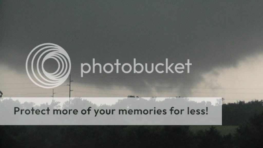
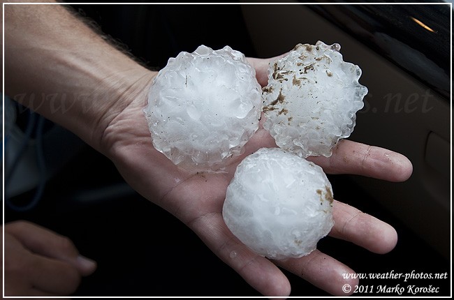
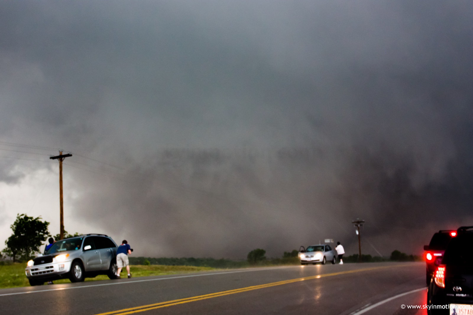
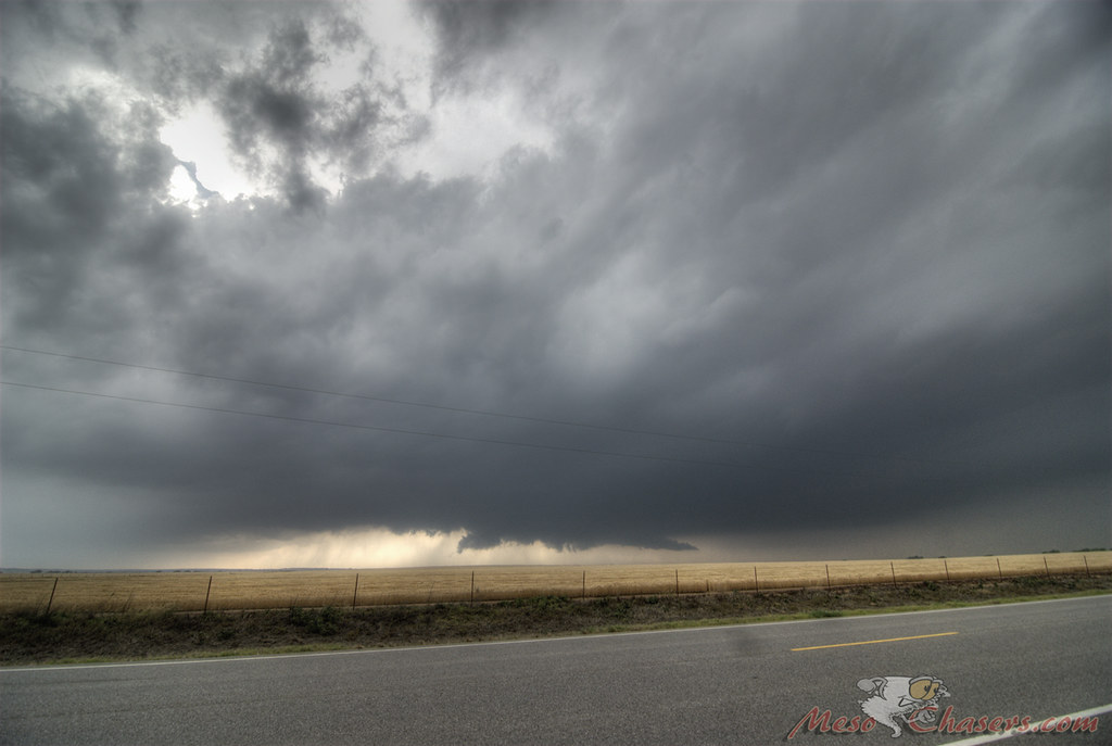
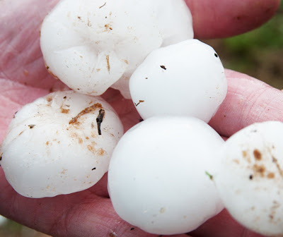
At any rate, I arrived at my final position at about 4:10. It was a nice empty gravel lot in front of a small steel building, in which I could point the car any way I wanted. In addition to occasional very close lightning, there was small hail and rain, so I couldn't get out and use tripods. When I arrived, all I could see to my southwest where two dark areas, with a bit of light between. The dark area to the left looked like a rain-filled wall cloud, where the only indication of rotation was in the periphery clouds above that it was connected to...call it the top edge of the bowl. The bottom was devoid of motion or sharp features. However, the dark area on the right became less obscured with rain, and was clearly a very large inflow band feeding in from the north. Being stuck in the car, I decided any footage would be better than none, so I took my camcorder off the tripod, turned on the image stabilizer, and started shooting/narrating from the driver's seat. I've always hated videos like this, but now I understand that sometimes it's the only way.

Over the next few minutes, the rain and hail subsided enough to where I decided to try and take some photographs. But it was so dark that at ISO 100, I was forced to shoot wide open (F 4.0 on a Canon 17-40L) at a shutter speed of 1/15. I got one crumby shot before the staccato lightning started up in earnest. So I got back in the car and started shooting video again.

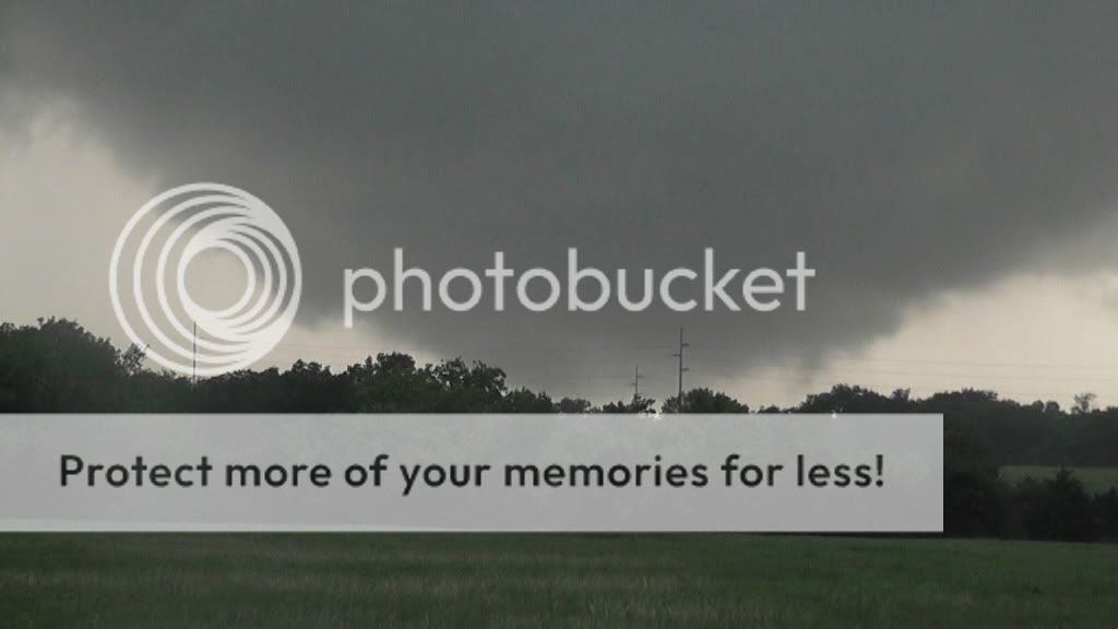
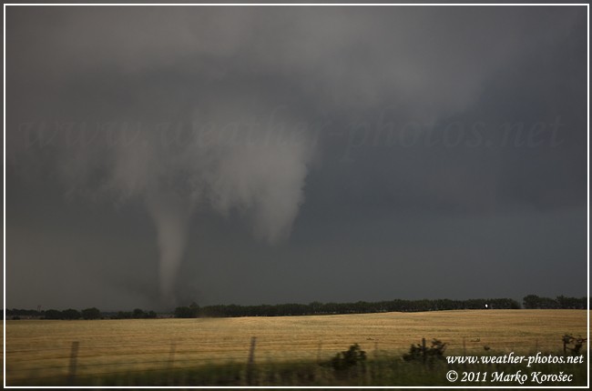
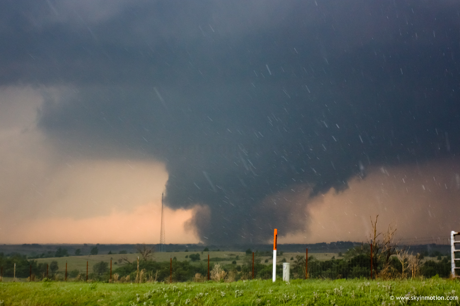
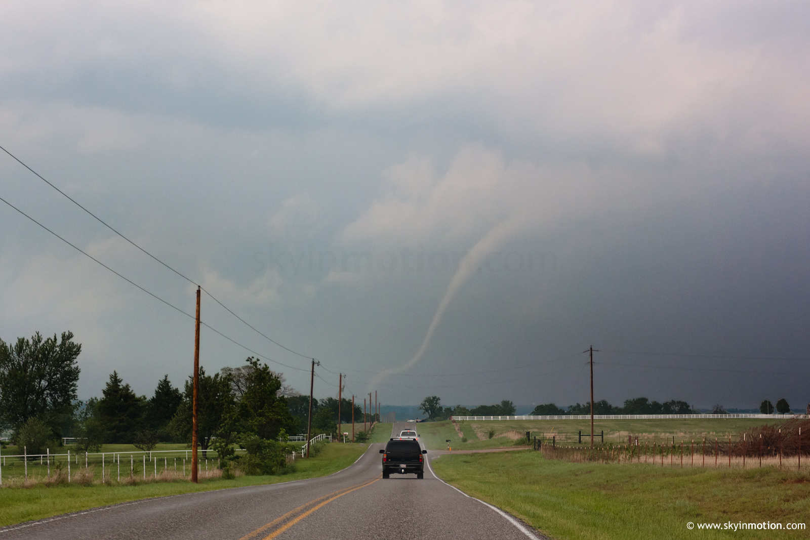
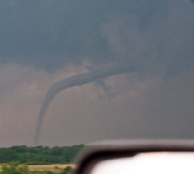
By now it was 4:22, and the southernmost part of the inflow band developed sustained rotation and a clearly-visible funnel, surrounded by very thin curtains of rain rotating around. I started to think this was going to be the action for the day. Most of my chases are like this. Meanwhile, the main base was still shrouded in very heavy rain with no apparent low level rotation. I've seen plenty of barely-moving wall clouds filled with rain before, so I figured this was just another one, and the area just north of it would be a good spot to watch. There were no tornado reports through the NWS web sites for this storm at the time (and there wouldn't be for several hours afterward).

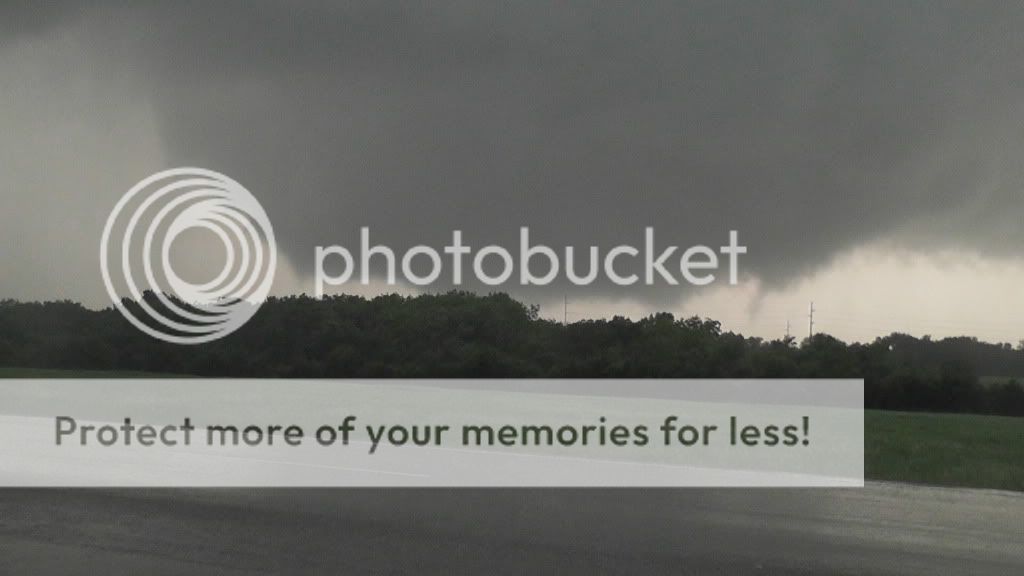
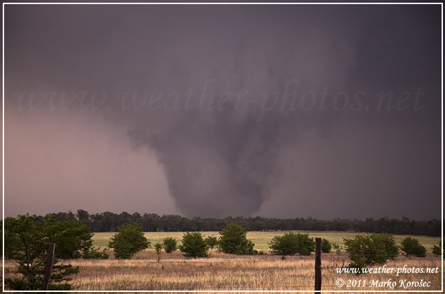
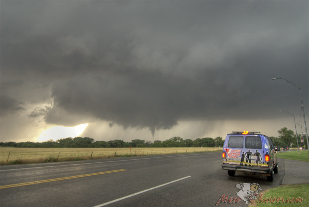
At 4:27, the funnel had mostly lifted, and tucked in behind the main base. At the time I thought it was just simply missing me to the south. Losing interest in this feature, I noticed a power flash under the main base, so I focused on that. Over the next 30 seconds, as I became embedded in the very outer curtains of the rain wrapping, a loose, ragged ground circulation became very apparent, and the motion of the rain curtains picked up a lot of speed. By 4:28 it was due south of me, and I knew I was looking at a pretty stout tornado. This was the first time I've ever heard the roar.

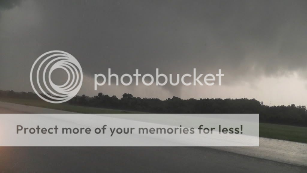
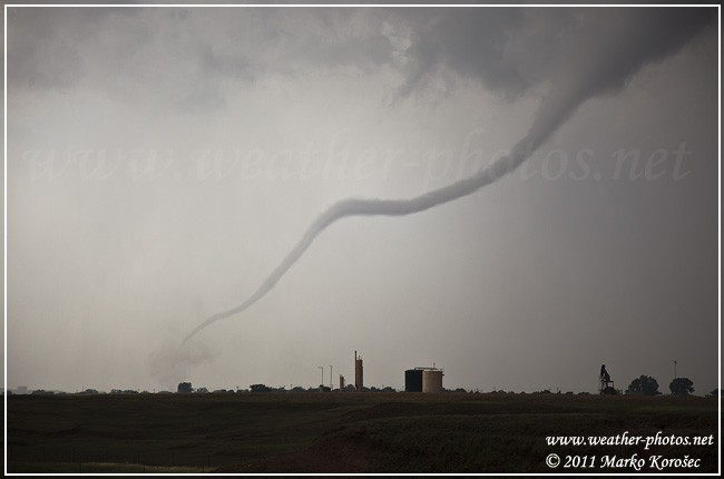
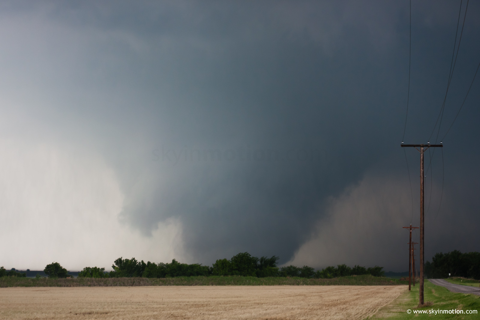
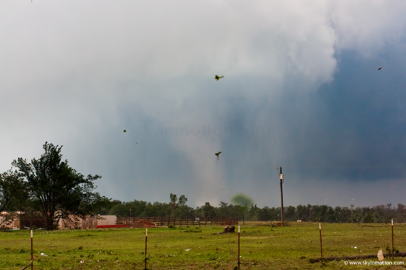
4:29 came, and even though the tornado was moving away from me, it dramatically increased in noise volume and rotation speed, while also becoming more sharply defined. It's possible that I was able to notice simply because it was closer than before, but it seemed to be intensifying really fast. It developed almost horizontal outer funnels reminiscent of the Tuscaloosa tornado videos. It was clearly a wedge by now, with a big plume of debris in front of it being thrown forward almost parallel to the ground. This was all stuff I hadn't ever seen before. Light improved dramatically as it passed, so I chanced going out to shoot photographs again. This turned out to be another epic failure, as RFD quickly precluded any chance of using a tripod. By 4:31, I'd given up fumbling with cameras, and got a final shot of the tornado moving away as it virtually disappeared behind the rain. There would be no chasing that tornado in that visibility, so I was done for the day.

The big lesson I learned was that while I've successfully employed tripods to shoot stills and video simultaneously, once the storm is nearby and ongoing, trying to switch to that setup from handheld video is a waste of precious time and footage. Of the 5-6 minutes where the main tornado was nearby, I probably wasted 2 of them trying to switch gears with cameras. Won't be doing that again.

I'll post the video just as soon as vacation ends and I get back up to Illinois.

Edit: Video Posted
http://www.youtube.com/watch?v=S5bUHt3fE8Y
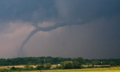
 
Last edited by a moderator:
I chased with Michael Seger. We got a late start out of Tulsa and were headed to El Reno or probably a bit south. Storms were blowing up on radar and though the Canton storm looked more impressive, we decided a better play was to head south and west toward the storm coming up from the Binger area. It turned out to be a good call. About eight miles southeast of Hinton we were looking south through the trees and spotted a large wedge. We called this in and shot some video and then headed back to the east to get out of the way. When we saw it again, the tornado had become much smaller and appeared to rope out. We followed the cell to El Reno, where we spotted a white cone tornado, almost impossible to see because of the low contrast and rain. When we tried to head east, we were blocked by downed power lines. Later, Kilpatrick Turnpike was shut down and we had to let the storm go.

The chase became personal because I watched the couplet intensify in the Piedmont area, and my parents live in a neighborhood just west of Guthrie. It appeared they were directly in the path of the circulation. After calling them and exchanging numerous texts with my dad, who was with my mom and neighbors in their safe room, it turned out the tornado narrowly missed their house. It also appeared to have weakened between Piedmont and Guthrie. Unfortunately it still heavily damaged three homes in their neighborhood.

We headed south for the Chickasha storm and got ahead of it on I-35. An OHP officer stopped to ask if we were okay and warned us to get away. There was a tremendous amount of rain and we never saw a tornado, though we did later spot minor damage along I-35.

Near Okemah we stopped to regroup at a gas station and found scores of other chasers, including Reed and his Dominator 2. We were ready to call it quits when we noticed a storm intensifying north of Okemah and headed off to follow it. There was a line of fifteen or so cars on the same road and we never caught up to it. Our day ended in Haskell, where we found more damage. We were also nearly out of gas, but couldn't fill up because the power was out in town. Rolled into Porter on fumes but found an open general store.

It was an intense day with so many storms interacting with each other and with my parents under the gun. Below are a couple of contrast-enhanced screen grabs from the video footage and one photo my dad shot of his friend's house.

wedge1.jpg


wedge2.jpg


cone1.jpg


cimarron_national.jpg
 
I tagged along with Jason and Rob for awhile, and so my YT video's perspective is from about 100 feet behind them at the start:

Watch video >

As stated in the description, the contrast was jacked way up for that first scene.

Later on, I chased the tornado coming out of Chickasha. I am still amazed at this radar image, for the proximity of these two tornadoes. Never before have I seen two *significant* tornadoes so close to each other!

Blanchard.jpg

Yeah, I use an absolutely funky, bizarre color table! It's great, for a couple reasons, while on the hunt.
 
Last edited by a moderator:
Intercepted the wedge as it rolled north over I-40 and stayed in front of it for a bit as I went north on Highway 81. After going east out of Okarche I ran into closed roads and eventually made my way back south and caught the storm that rolled through Moore but was too late as it didn't produce anything after I arrived. Eventually chased to the east to Seminole but once again I missed the tornado that was produced and called it a day at that time.


wa61qs.jpg


2z8aihv.jpg
 
Last edited by a moderator:
Got out of work in Norman at 4:30, raced to Chickasha, intercepted the most incredible tornado in my life. Shades of May 3, 1999 - It's the shot I have waited my entire life to see.

Watch video >

After I got back to SH-9/Norman Spur intersection, I headed east and got onto the SE Norman cell and raced it to I-40. I caught the Tornado crossing I-40 that hit the semi a mile west of Firelake Casino.

Watch video >

Full map, chase recap, etc at http://www.benholcomb.com/Chase-Accounts/20110524
 
I started my day departing North Edmond, at approximately 12:30pm with a target area of Hennessey, Ok. It didn't take long at all to notice the first targets coming in on radar in Western, Oklahoma. I decided to go with the Northern Target since it had the best looking radar signature. I intercepted the storm on US 58 about 5 miles South of Canton, Ok. I was immediately greeted with this....

5756818757_dd0b6c6782_b.jpg

The wall cloud cycled a couple of times with brief funnels each time before really tightening up and dropping the tornado...

5757295854_72a1475407_b.jpg


The shot above was the last still photo I took before rolling my video...Watch video >

My chase partner/driver and I both have our entire families in the OKC area. So, after losing the Canton Wedge, we opted for racing back to OKC to be with our families. We just barely beat the El-Reno/piedmont storm back before it crossed the Guthrie, I35 area. I live just a few miles South of Guthrie, Oklahoma. From the moment I noticed the cell in Hinton, that had a storm track on it for my general home area...I have to tell ya, it's not an easy feeling, as some of you probably found out yesterday. It sure puts a different perspective on storm chasing.
 
I got this nice rope tornado just south of Fairview, OK. I got on the storm early and watched a wall cloud too long and due to bad road options the storm passed me, so we played catch up and missed the Canton tor since rain blocked our view. We got back into position just in time for this nice rope

Watch video >
 
http://www.youtube.com/watch?v=Sav26yxYdmk
intercepted the chickasha tornado right as it touched down. We drove right up next to it and it destroyed several houses 1 block to our east. We continued to track the tornado until it dissipated over moore
 

Attachments

  • NewWedge2.jpg
    NewWedge2.jpg
    7.8 KB · Views: 81
  • NewWedge15.jpg
    NewWedge15.jpg
    8.3 KB · Views: 57
  • NewWedge5.jpg
    NewWedge5.jpg
    7.3 KB · Views: 53
  • NewWedge9.jpg
    NewWedge9.jpg
    10.8 KB · Views: 56
  • NewWedge7.jpg
    NewWedge7.jpg
    11.7 KB · Views: 56
Last edited by a moderator:
Chased with Keith Turner and we intercepted the Chickasha torando at close range as it was moving through town. Followed it back up into Moore.

 
Had targeted the Ponca City area the night before but after seeing some HRRR and Ruc runs switched my target to El Reno. After it looked as though the dryline was a bit farther west than forecasted decided to move west to Weatherford. Just as we were about to get off the Weatherford exit the first little blip showed up on radar and we followed it up towards Canton Lake where we got the wedge.
<iframe width="560" height="349" src="http://www.youtube.com/embed/DYA7svNtFls" frameborder="0" allowfullscreen></iframe>

A few minutes later got the rope near Fairview.
<iframe width="560" height="349" src="http://www.youtube.com/embed/t1vKfkbYf2E" frameborder="0" allowfullscreen></iframe>

Then went after the storm that moved through El Reno. As I'm sure most of you know the drive from Fairview to cut off that storm wasn't easy since punching a couple cores were required but we got in positioin to intercept at Guthrie. Unfortunately the storm had gone somewhat linear and was wrapped in hail and rain. I didn't want to risk getting any closer to the rotation with zero visability so ended up backing off and going after the cell that moved through Moore/Norman area. Intercepted it at Choctaw Rd and Alameda Dr. The best place we could video was not very good and as the wall came over us it put a very brief weak spin up down that had us fleeing. Wish we could have had video because it was quite a sight looking out the rearview and seeing trees bent over in half. It did very little damage other than a few small limbs down before picking right back up. Not knowing the area, I got cut off by the Lake and got decent video of the wall moving over the lake just before it put a tornado down that ended up flipping the 18 wheeler on I-40.

As I got back to I-40 another area of rotation tried and came fairly close to putting a tornado down.

We then dropped south to try and get some of the cells moving through the red river area. One cell south of McCalister looked great as we passed it by but decided not to chase because of terrain, it was getting dark, and an extreme lack of roads. This cell ended up tracking all the way through East OK and put down a large tornado just to the East of Ft. Smith. Managed to get south to Paris, Tx to see the cell that moved through Sherman, Tx. We watched it cross over the Red River and it had amazing structure. At times I think it put some small tornadoes down but couldn't confirm since it was dark. It certainly had numerous funnels and was a lot of fun to watch.

Shortly after that cell died and we decided to stay in Little Rock so we wouldn't have a long drive in the morning. The drive from Broken Bow, Ok to Little Rock is a disaster and one I'll never make again.
 
EDIT: I've finally been able to capture some video, which is available on YouTube at http://www.youtube.c...h?v=TaTZE8DU98E. After full condensation, contrast got sub-optimal as rain streamed inward towards the circulation. The data we collected are spectacular, with extreme radial velocities as the tornado moved from 3 km to 10 km to our south through east. The data are also very preliminary, and we want to make sure it's correct before giving specific numbers.

I was out with Howie Bluestein and Jana Houser Tuesday, in the operator's seat of RaXPol. Our initial target was somewhere W of El Reno. We knew that we wanted to get west of the I35 corridor, but there was little latitudinal clarity. When I went to bed Monday night, it looked like the OK/KS border was going to be the hot spot. By the time I awoke early Tuesday, the latest model data and observations seemed to indicate clearly that almost the entire central 1/3 of Oklahoma was going to be under the gun, and I could find little reason to pick one location over another. My primary hesitation with heading northward towards the OK/KS border region was the forecast of relatively backed mid-level flow, whereas the flow was progged to be more veered aloft S of I40. Since we didn't really know where we wanted to end up, we just headed westward from OKC towards Hinton.

It was apparent that we weren't going to be able to catch the storms N of I40 considering the initial motion that looked to be NNE then NE. I also was very concerned about getting behind the storms, since observations and numerical forecasts indicated that the low-level shear wasn't going to be particularly favorable for the high-end tornadoes until after 4-5 pm. The RUC and 12z NAM looked to be much too far west with the dryline, and the HRRR seemed to match the more eastern position of the dryline considerably better. At any rate, we opted to try to deploy ahead of the southernmost updraft of a cluster located near Lookeba and Alfalfa. When we were up and scanning, there was an apparent tornado in progress to our southwest. Visually, we couldn't see a tornado, at least there was no condensation that was hanging lower than the already-low wall cloud that showed its face after the FFD moved through. Rotation rapidly increased to our immediate southwest. I went from thinking that we may be too far east (using the then-current NE motion) to realizing that the meso was making a beeline at our location. The low-level meso looked to turn right further, and we got a fully-condensed multivortex tornado to our SW shortly thereafter. The tornado grew in size to our immediate (~2 km) south and moved relatively slowly to the east-northeast. Although we were out of the hail (presumably under the updraft enough), we did experience some light rain at our location. Combined with the lightning, we were forced to remain in the truck, preventing any tripodded video.

This tornado had a spectacular horizontal vortex on its north side. We'd see occasional horizontal and U-shaped vortices to the immediate northeast of the condensation funnel of the tornado, although the horizontal rotation took on a rolling pin appearance at times (very wide cylinder rotating on a horizontal axis - see video starting around 4:15). The tornado moved off to our southeast then east, and we were blasted by Howie-estimated west-northwest winds of ~70 mph. We left the storm when the tornado moved into the range beyond which we experience complete attenuation / extinction. Since we couldn't get E on I40, we had to tracked W, S, then E on on 37 towards Tuttle, crossing an apparent damage path on US 281 between Lookeba and Hinton (IIRC). We collected another close tornado dataset at the 37 / I44 interchange, approximately 2 km from the northward-moving, weakening tornado that had been a beast NE of Chickasha. Farther to our southeast, we could see (via radar) the tornado near Goldsby. We tried one last attempt to get ahead of this storm and the one closer to PVJ, but those attempts were futile as the storms moved more rapidly to the northeast.
 
Last edited by a moderator:
Piedmont Tornado

Started in El Reno. Sadly, I decided to move north to play the Canton storm. Lost internet data so I tuned to a radio station broadcasting KFOR's coverage. Heard about the southern storm producing near Hinton. Decided to go back south (great way to waste an hour). Had to move east to take 81 south to intercept. Made it to Okarche and realized that I may not make it if I stayed on 81 so I took the NW Expy. a few miles east to Banner Rd. which I took south to nearly Hefner Rd. and waited. Was treated to possibly the last great, mostly rain-free view of the beast. Took Britton Rd. further east and ended up giving up trying to intercept again, realizing that it would likely remain very non viewing friendly. The rest of the evening was quite frustrating as I was ever so slightly late to other tornadoes (Chickasha, Goldsby, Shawnee). Very brief video (that does no justice to the power) below:

Watch video >
 
Good day all,

Like many others, intercepted tornadoes and observed multiple supercell storms. May 24 was a typical high risk chase day, with nearly all the supercells in a cluster of supercells producing tornadoes, so there are many different aspects of this day from chasers all around.

I started out for storm initiation near I-40 and Highway 183, near Arapaho and worked my way east. The first real significant storm was the Canadian county storm from near I-40 and highway 270 and to the east-northeast through Piedmont. This storm produced a possibly violent rain-wrapped tornado. The second storm was later east on I-40 northwest of Shawnee, with a small but very intense tornado crossing the road and ripping a semi-trailer to shreds (driver was injured and I stopped to assist).

m12tor13.jpg


Above: Looking south towards I-40 in some of the darkest conditions I have ever seen at the rain-wrapped wedge (loud roar also audible at this time). This was south of Calumet on Highway 270 about a mile 1 or 2 north of I-40.

m12rad6.jpg


Above: Radar image (velocity) from GRLevel3 about the same time when the first picture of the rain-wrapped wedge was taken.

m12tor15.jpg


Above: Tornado crossing I-40 NW of Shawnee, OK.

m12tor16.jpg


Above: Closeup of I-40 tornado near Shawnee. Debris is from the semi trailer it hit and tore up.

m12trk1.jpg


Above: Remains of large semi-trailer after the tornado hit it. The (very lucky) driver had a sprained leg and some cuts, but was otherwise OK.
 
Last edited by a moderator:
Caught the wedge near Canton Oklahoma and the rope out near Fairview. Chased with Terrence and Brittany Cook.

Started the day in Hoisington KS. Departed for the border of KS/OK around 11am and quickly determined that we must push further south. Leaving Kansas behind was hard as we knew there was going to be some action near the low & WF. This turned out to be quite true with a number of tornadoes within 15 miles of our home base. Thankfully we scored in Oklahoma and didn't have to shoot ourselves...

This chase was a bit difficult due to A) mediocre road network/terrain and B) poor data. We were amongst the trees when the first tornado(wedge) was getting its act together. This forced us to fly east out of the trees to get to a nice N/S highway where the tornado was viewable:

attachment.php


The plan was then to intercept along the highway as it crossed north of us. Unfortunately (or not) the tornado wrapped with rain and weakened as the meso occluded and another area of rotation became dominant closer to the road. Thankfully we got a much better look at this little tornado.

attachment.php


Given our data issues we ended up staying with the northern storms too long and couldn't make it down to the south for anything along I-40.

All in all... a good, if not difficult, chase.
 
Just wanted to put a brief update in here that I intercepted the El Reno tornado just north of El Reno and was within 2000 feet of the rain wrapped torn. I barely caught it due to gas and gps issues. I have some video but most if it is poor. No time for photos. Also intercepted the cell producing the Moore tornado and I believe I saw it in the distance as it was weakening but I got blocked / stopped by the damage path. I spent most of Wednesday driving the El Reno damage path and using Street Atlas and gps to mark debris path and damage track, measure widths and distances along with my distance from the torn. I'll try and do my full report soon, but here are some of my quick stats I logged regarding the tornado:
***
Overall damage path width including any / all peripheral damage (broken big tree limbs, etc): 3.26 miles
Primary extensive damage path width: 1.62 miles wide
Includes house removed from foundation and 90% of debris swept clean - large trees shredded, broken, debarked. This indicates

EF4 and possible EF5 strength at that location IMO.
(Note: Later after this assessment I saw earlier footage indicating more debris on the area - so perhaps some was cleared by the
time I arrived)
Distance from my location to perceived tornado edge 2000 feet.
Distance from my location to peripheral damage path edge 1.17 miles
Distance from my location to major / extensive damage path 1.6 miles


*****
This was my 4th tornado of the season so far. I'll have to review streaming and dashcam footage to determine if what I witnessed
just sw of Moore was the tornado (had many trees and hills in my way so only brief glimpses). Moore would make my 5th.

I also got Baird, Tx, Gatesville Tx, Nemo, Tx. I'm counting Itasca, Tx as a funnel because I never saw it touch ground though some claim it did. Guess I need to review that footage as well.

Unlike me to not document any of these chase accounts but just haven't gotten around to it. I haven't posted to my website, Stormtrack, WxChase, etc. I was about to start doing some of that and now for instance I look at the models and I may be headed to Oklahoma again tomorrow. I just got back late last Wednesday night and spent the day Thursday getting new tires, fixing side mirrors which had broken loose and other vehicle junk.

El Reno was a monster...sounded like a big waterfall with rushing water.
 
Last edited by a moderator:
Back
Top