2011-05-22 Joplin, MO tornado thread

  • Thread starter Thread starter Drew.Gardonia
  • Start date Start date
Happened to come across this audio on Youtube. It's the audio from the emergency management radios starting as the storm approached Jopin, continues as the tornado goes through Joplin, and finishes with the assigning and managing of emergency personnel in the chaos following the tornado.

In my opinion it is very tough to listen to knowing how bad things got and the fact that for the most part everyone in the video is mostly oblivious to the scope, magnitude, and historical significance they have been thrust into. Having said that, I think it is important for us as chasers to listen to it. A lot of times, we are some of the first people on scene in these situations. However, this will really open up your eyes to how quickly and efficiently emergency management is able to kick into action to get help to where it is needed. It also amazes me how quickly mutual aid from surrounding towns were either already in town or calling in to see if they were needed. This audio by itself is chilling. Actually being a first responder and being there in the chaos is something I can't even fathom. A big salute to police, firefighters, EMT, and all other first responders and emergency management personnel everywhere.

 
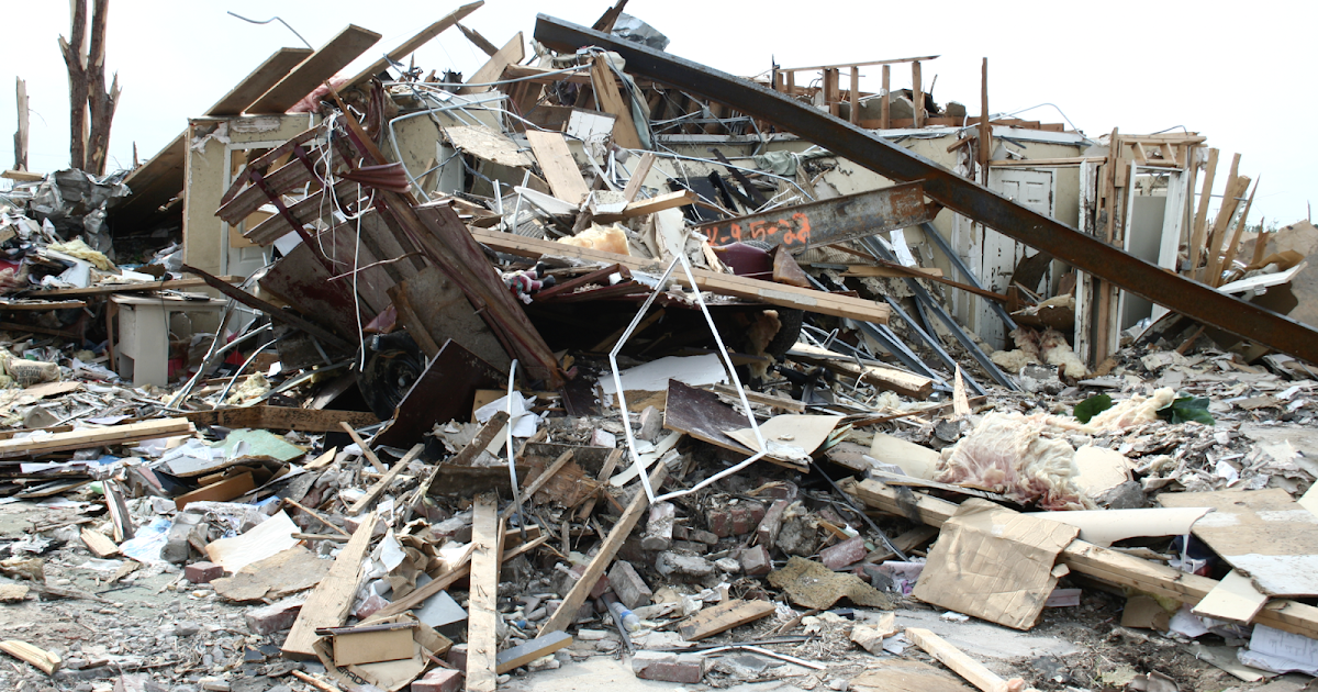
There have been volumes written about the Joplin tornado in regards to intensity and freak damage reports. I will say of all the storm damage I have encountered in over 35 years of journalism / storm photography, Joplin was by far the most extreme. This includes damage from all three Moore, OK tornadoes I surveyed. I believe the most impressive damage from Joplin was the hospital being rotated 4 inches off the foundation. I personally believe individual vortices reached well over 300 mph.

Joplin-tornado-damage.jpg
 
There have been volumes written about the Joplin tornado in regards to intensity and freak damage reports. I will say of all the storm damage I have encountered in over 35 years of journalism / storm photography, Joplin was by far the most extreme. This includes damage from all three Moore, OK tornadoes I surveyed. I believe the most impressive damage from Joplin was the hospital being rotated 4 inches off the foundation. I personally believe individual vortices reached well over 300 mph.

View attachment 17270

This. It is a travesty to me that Joplin's EF5 rating is marked "disputed" on the Wikipedia list of F5 and EF5 tornadoes based on the ASCE study. Barring a worst-case scenario like tracking along a gridlocked freeway at rush hour or hitting a packed sporting event or concert venue, a tornado simply does not kill >150 people in this day and age without being exceptionally violent.
 
This. It is a travesty to me that Joplin's EF5 rating is marked "disputed" on the Wikipedia list of F5 and EF5 tornadoes based on the ASCE study. Barring a worst-case scenario like tracking along a gridlocked freeway at rush hour or hitting a packed sporting event or concert venue, a tornado simply does not kill >150 people in this day and age without being exceptionally violent.

Number of fatalities has nothing to do with tornado damage rating. The EF-scale uses estimated wind speeds...period. It has been well discussed that all but the most well-constructed and secured single-family homes fail at speeds well below the EF5 threshold. So you generally cannot use a single-family home (the most common and representative damage indicator from the old Fujita scale) to justify an EF5 rating on a tornado. Also, the wind speed ranges for many DoDs in many DIs are themselves only estimates. It can be difficult to state unequivocally exactly how fast of wind it takes to do a certain degree of damage to a given structure. Some structures may twist/bend/fail at surprisingly low (or high) speeds. We just don't know.

The aim of the EF-scale was to have an objective basis on which to rate tornadoes rather than to be subjective and base ratings on emotional aspects or human injury/death tolls, both of which are very difficult, or impossible, to quantify.
 
There have been volumes written about the Joplin tornado in regards to intensity and freak damage reports. I will say of all the storm damage I have encountered in over 35 years of journalism / storm photography, Joplin was by far the most extreme. This includes damage from all three Moore, OK tornadoes I surveyed. I believe the most impressive damage from Joplin was the hospital being rotated 4 inches off the foundation. I personally believe individual vortices reached well over 300 mph.

View attachment 17270


That is an incredible picture, I can barely wrap my mind around what that is even showing because there is no familiar context for such a combination/interrelationship of things... Clearly looks like a truck cab, but almost looks like the tree trunks are in the middle of the chassis???
 
It's the 10th anniversary of the Joplin tornado. It more than doubled the individual death toll of either the Hackleburg/Phil Campbell or Tuscaloosa/Birmingham, AL tornadoes (themselves the deadliest U.S. tornadoes since Udall, 1955) from less than a month earlier, with no others even close (fortunately) in the 56 years in between or ten years since.
 
To answer the question above (such as, "I wonder why they didn't issue a TE), I am sending a link to a brief piece explaining what went wrong with the warnings that afternoon (everything!). Or,
"a tornado simply does not kill >150 people in this day and age without being exceptionally violent."

While I agree it was an exceptionally violent tornado, that is not the reason for the extraordinary death toll. Many of the answers are below.

 
Some news: Earlier today, for the first time, KSNF-TV (NBC) in Joplin released the entire video of its tornado coverage. It is here:
I tried to license it for the second anniversary but the TV station's general manager wanted $3,000. Glad it is available free.

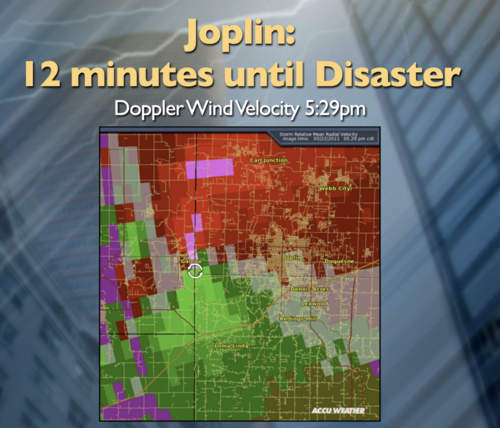
I didn't think it was possible but the video makes the NWS look even worse. You can hear meteorologist Caitlin McCardle and newscaster Jeremiah Cook speaking, multiple times, about "trying to confirm a funnel cloud near Riverton." The Level 3 (all that was available then) base velocity at the time is below. That is a strong couplet moving straight for south JLN. Why were they fooling around making phone calls trying to "confirm" a funnel cloud report with Cherokee County, Kansas, emergency management? It was obviously correct. Get the info out and move on!

The whole confusing mess began when SGF NWS believed a scary looking cloud "funnel" near Carl Junction and issued a tornado warning on it. In 2011, they were still operating as if it was 1975.

3 Doppler base reflectivity, Joplin, 529p.png
 

Attachments

  • Screen Shot 2023-05-22 at 5.50.54 PM.png
    Screen Shot 2023-05-22 at 5.50.54 PM.png
    1.3 MB · Views: 1
Back
Top