Wayne Sclesky
EF0
March 12, 2006
My chase day started in Miami Florida on March 11th at 3:00PM. Well it really wasn’t a chase day, I was moving back to Kansas City. I had spent the last year in Miami doing beauty and fashion photography. Got tired of Miami and decided to head back to the Central U.S. I stopped in Murfreesboro, TN at 5:00am on the 12th. When I arrived at the motel and connected my laptop to their WiFi and got the day 1 out look I knew the drive the rest of the way might get rough. Right through a good portion of the area I had to pass through to get to KC was the elusive “high-risk†circle. I was going to sleep in, but decided I should leave at 8:30am and try to beat any storms that were going to fire up.
I woke up at 8:00am on the 12th. I checked the SPC page, noticing their warnings in the KC area, I called my Mom and girlfriend to warn them of the impending storms. I hopped in the car and got headed to KC.
Most of the drive was very uneventful. As I got the Saint Louis area I started paying more attention to the skies. Through my Sprint PCS I can get access to radar and some forecasting data through “My-Castâ€. Pretty handy to have as long as I can get a signal. As I was about 30 miles from Columbia I noticed the first couple of cells that were heading up through Sedalia and would be coming close to Columbia or Boonville. Not having any maps to navigate with or my weather radio I thought it would be best to stop at a friends in Columbia, wait for the storms to pass over I-70 then continue on to KC.
I got to my friends and pulled up the NWS radar and started watching TV to get storm information. From the radar and looking at the SRV it looked like the current areas of rotation would pass to the west of Columbia, however the media was projecting the storms to head right to Columbia. My friend had no basement and had just left for church. I sat there for a few minutes and the storm chaser in me took hold. Better to chase than be chased!
I left his residence, which is on the west side of Columbia. I made my way to Highway 63 and proceeded south to get into a better viewing position. I took my first images at exactly 5:10PM. I observed a large wedge tornado that appeared to be weak. The only reason it was visible was due to the rain forming the wedge shape. This persisted for about 30 seconds before dissipating or being occluded from precipitation. I watched several updrafts turn slightly, but no organized rotation that I would call a “well-defined†wall cloud.


As soon as the storm was clear I proceeded north on 63 to I-70. Remember I wasn’t chasing, I was trying to get home. And actually I was going to surprise my girlfriend by getting back to KC a day earlier than I told her. Up to this point I was telling her I was in Georgia and not anywhere near the mess I was about to really get in. I got onto I-70 and proceeded West. After crossing the Lamine River about mile Marker 90 I came to a huge traffic jam. I spent most of my time sitting and it took me at least an hour to go about a mile. Traffic was being detoured onto county road AE to J hwy, then back onto I-70. I will assume the traffic backup was related to the first storms crossing over the interstate. Now, however there were more storms approaching the interstate with current tornado warnings. As I got to J hwy. and I-70 I was on the phone with my brother having him give me some now-casting and try to get me down I-70 without running into a tornado or large hail. All the while I would intermittently talk to my girlfriend acting like I was stuck in a traffic jam in Georgia! We decided I should head to the clover leaf at I-70 and 65 hwy and reassess the situation. Once I got to that point and reassessed, it was decided that it wouldn’t be a good idea to proceed down I-70. The hook from the storm was running along I-70 and was headed towards my location.
I decided to head back to J highway and I-70. If need be I could go south on J to 65 highway, or get back on to I-70 once the storm had cleared. As I sat on the south side of I-70, I was being hit by massive inflow, through the lightning flashes I could see a large wedge tornado working its way to my northwest. My guess is it was about 1-2 miles from my location. My brother thought it would be best for me to head South on J and hit 65 hwy a few miles south of I-70 and then proceed back north to I-70. That is exactly what I did. I was very relieved to get onto I-70. It was at this time I had to tell my girlfriend about how I was going to surprise her, but I was concerned for my safety and wanted her to know I was almost there. More storms were approaching from the Southwest and I knew I had to keep things moving to get west before I ran into them crossing the interstate. Just when I was thinking things were looking good…once again…traffic jam!

this was shot at 3200 ISO on my Canon 5d handheld at 2.5 seconds from in my car!
For at least 20 minutes there was no movement whatsoever of the traffic. There is no worse feeling than knowing that in a few minutes I might find myself in a ditch hoping for the best! Of course another storm was headed right towards my location with a current tornado warning. Slowly traffic got moving. This time the wreck was from a semi that had been flipped over onto a couple of cars that were parked under an overpass. This was from the tornado that I had just witnessed a few minutes before. If I would have proceeded instead of waiting when I did back at J highway and I-70…I know that I would have been in that mess or very close.
After the last traffic jam there was only one more storm to beat before I was finally in the clear, it was once I got past 13hwy and I-70 that my brother said that I am finally in the clear. That was a great feeling of relief. It took me 5 hours to drive 90 miles. If it were not for the traffic backups on the interstate I would have been fine, and perhaps would have even stopped to get some better photos. I have been thinking about getting wxworx system, after this event, I am thinking even more about it!
My chase day started in Miami Florida on March 11th at 3:00PM. Well it really wasn’t a chase day, I was moving back to Kansas City. I had spent the last year in Miami doing beauty and fashion photography. Got tired of Miami and decided to head back to the Central U.S. I stopped in Murfreesboro, TN at 5:00am on the 12th. When I arrived at the motel and connected my laptop to their WiFi and got the day 1 out look I knew the drive the rest of the way might get rough. Right through a good portion of the area I had to pass through to get to KC was the elusive “high-risk†circle. I was going to sleep in, but decided I should leave at 8:30am and try to beat any storms that were going to fire up.
I woke up at 8:00am on the 12th. I checked the SPC page, noticing their warnings in the KC area, I called my Mom and girlfriend to warn them of the impending storms. I hopped in the car and got headed to KC.
Most of the drive was very uneventful. As I got the Saint Louis area I started paying more attention to the skies. Through my Sprint PCS I can get access to radar and some forecasting data through “My-Castâ€. Pretty handy to have as long as I can get a signal. As I was about 30 miles from Columbia I noticed the first couple of cells that were heading up through Sedalia and would be coming close to Columbia or Boonville. Not having any maps to navigate with or my weather radio I thought it would be best to stop at a friends in Columbia, wait for the storms to pass over I-70 then continue on to KC.
I got to my friends and pulled up the NWS radar and started watching TV to get storm information. From the radar and looking at the SRV it looked like the current areas of rotation would pass to the west of Columbia, however the media was projecting the storms to head right to Columbia. My friend had no basement and had just left for church. I sat there for a few minutes and the storm chaser in me took hold. Better to chase than be chased!
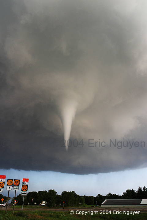
I left his residence, which is on the west side of Columbia. I made my way to Highway 63 and proceeded south to get into a better viewing position. I took my first images at exactly 5:10PM. I observed a large wedge tornado that appeared to be weak. The only reason it was visible was due to the rain forming the wedge shape. This persisted for about 30 seconds before dissipating or being occluded from precipitation. I watched several updrafts turn slightly, but no organized rotation that I would call a “well-defined†wall cloud.
As soon as the storm was clear I proceeded north on 63 to I-70. Remember I wasn’t chasing, I was trying to get home. And actually I was going to surprise my girlfriend by getting back to KC a day earlier than I told her. Up to this point I was telling her I was in Georgia and not anywhere near the mess I was about to really get in. I got onto I-70 and proceeded West. After crossing the Lamine River about mile Marker 90 I came to a huge traffic jam. I spent most of my time sitting and it took me at least an hour to go about a mile. Traffic was being detoured onto county road AE to J hwy, then back onto I-70. I will assume the traffic backup was related to the first storms crossing over the interstate. Now, however there were more storms approaching the interstate with current tornado warnings. As I got to J hwy. and I-70 I was on the phone with my brother having him give me some now-casting and try to get me down I-70 without running into a tornado or large hail. All the while I would intermittently talk to my girlfriend acting like I was stuck in a traffic jam in Georgia! We decided I should head to the clover leaf at I-70 and 65 hwy and reassess the situation. Once I got to that point and reassessed, it was decided that it wouldn’t be a good idea to proceed down I-70. The hook from the storm was running along I-70 and was headed towards my location.
I decided to head back to J highway and I-70. If need be I could go south on J to 65 highway, or get back on to I-70 once the storm had cleared. As I sat on the south side of I-70, I was being hit by massive inflow, through the lightning flashes I could see a large wedge tornado working its way to my northwest. My guess is it was about 1-2 miles from my location. My brother thought it would be best for me to head South on J and hit 65 hwy a few miles south of I-70 and then proceed back north to I-70. That is exactly what I did. I was very relieved to get onto I-70. It was at this time I had to tell my girlfriend about how I was going to surprise her, but I was concerned for my safety and wanted her to know I was almost there. More storms were approaching from the Southwest and I knew I had to keep things moving to get west before I ran into them crossing the interstate. Just when I was thinking things were looking good…once again…traffic jam!
this was shot at 3200 ISO on my Canon 5d handheld at 2.5 seconds from in my car!
For at least 20 minutes there was no movement whatsoever of the traffic. There is no worse feeling than knowing that in a few minutes I might find myself in a ditch hoping for the best! Of course another storm was headed right towards my location with a current tornado warning. Slowly traffic got moving. This time the wreck was from a semi that had been flipped over onto a couple of cars that were parked under an overpass. This was from the tornado that I had just witnessed a few minutes before. If I would have proceeded instead of waiting when I did back at J highway and I-70…I know that I would have been in that mess or very close.
After the last traffic jam there was only one more storm to beat before I was finally in the clear, it was once I got past 13hwy and I-70 that my brother said that I am finally in the clear. That was a great feeling of relief. It took me 5 hours to drive 90 miles. If it were not for the traffic backups on the interstate I would have been fine, and perhaps would have even stopped to get some better photos. I have been thinking about getting wxworx system, after this event, I am thinking even more about it!