2006-03-12 REPORTS: KS, MO, IL, IA, OK, AR

Joined
Dec 8, 2003
Messages
2,208
Location
Kansas City, Missouri
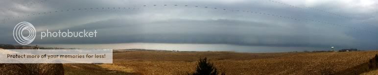
Think it's early for a chase report? So do I ... Woke up at my mom's this morning to the sound of the wx-radio blaring a tornado warning and svr t-storm warnings in Kansas. (3/14 EDIT: just wanted to note hear that the tor-warning was called for a high wind event in Lawrence that has later been confirmed as a bizarre downburst event ... this caused some noteworthy damage in Lawrence and even closed KU the next day.) Got ready real quick and went out to grab a couple shots of the elevated Buchanan Co. storm as it crossed the river into Missouri ... excellent shelf ... here are a couple quick pics ... could not get in a good spot in the hills. -- the bad news is that this storm had to have been moving every bit of 50 mph, if not more ... it took no time for it to cross over my head and move north over Agency and then to Dekalb Co. If they are all this way today, we're in trouble.

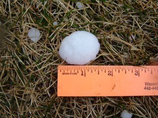
I'm talking to my mom on the phone as I write this and can hear the large hail hitting her house - it sounds terrible. She says it's covering the ground. My brother says it's tearing the trees APART in St. Joe ... he can't see across the street because there is so much hail coming down.

Then I came back to KC, where the hail was still covering the ground and lining the roads. North KC near KCI took this one on the chin, looks like - unfortunately the worst of it appeared to be around all of KCs most high-dollar luxury car dealerships ... Lexus, Acura, Humvee, etc. were all in the path of the hail core on this one. Zona Rosa also got it, looked like - getting ready to head back out - -

weather0023net.jpg


weather0038net.jpg


Here's a quick merge of the Buchanan Co. storm base ... no time to clean up now ...

mergeBuchananCo.jpg
 
Woke up to hail here at my house. I am only a couple of miles from Zonarosa that Mike mentioned. Went to the door to watch a very dark cloud moving in with the hail. The winds were blowing pretty strongly too...and it looked like the table on the back deck was getting lifted. Anyway.....to my south I saw a dark cloud hanging down behind the trees. I wish I could have seen better but the trees were blocking my view. I thought I better take a look at the radar so I quickly went to my computer and saw we had a tornado warning and there was a supercell with a well defined inflow notch and appendage right about where I live! So I decided it was time to make a quick move to the basement. Stayed there a few minutes then went back up as the hail subsided. The neighbors shed next door had some minor roof damage and we had alot of hail on the ground....probably about an inch, some slightly larger, in diameter covering the ground. Pretty interesting morning to say the least. The storm that came through here about 3 hours ago is now approaching IL and still producing. Very impressive for surface temps in the 40's.
 
Hail at 8:29am here in South-Central Leavenworth County just about 10 miles west of the Kansas Speedway:

DSC04280.jpg


Hail lasted for a cople of minutes, accompanied by about a 1-minute long burst of ~50mph winds, 0.08" of rain, and then it was gone.
 
I was sleeping in today after running almost 400 miles in 2 days for Civil Air Patrol...

0930 Burlingame, KS (8 mi to my North) had 3" hail. Friends of mine lost a skylight but were luckier than their neighbors - They had hail punch their roof and ceiling and into their house.

One of my friend's nephews was driving to Osage City to work when hail pierced the roof of his Neon. Luckily no injuries.

1240 had sirens go off here in Osage for a TOR warning. NWS TOP had a cell with rotation abt 12 mi to the South. Jumped and ran to check that out but by the time i got close to the area it was East and North of me. I did sit and watch some interestting rotation from the backside on a hill with some AMR paramedics North of Melvern lake.

Doesn't look like it's over for the day either...

Jon Holder
 
Report from Lawrence

Big Day here in Lawrence, Kansas. I live about half a mile Southwest of Allen Fieldhouse.

I woke up this morning around 8 am with a thunderstorm going on outside. The wind started howling....and howling. I'd never heard wind like that before. I looked outside and it was evident that our house and immediate neighborhood was being hit by a tornado...at first I thought it might be straight line winds but the rotation was obvious...we were inside a rotating vortex with a roar that I'd never heard before. I'm quite certain it was a tornado, albeit a weak one, F0. Local radio reports lots of people in Lawrence reporting funnels.

The storm passed quickly. Our house has only slight damage, but some neighbors lost major tree limbs. Cars in the area were destroyed by trees. A school crossing sign across the street was ripped out of the ground. The power was out from 8 am to just now.

There is substantial damage through much of the city. It looks like the KU campus was hit particularly hard. Local radio reports that an air conditioner unit was ripped off a high-rise dorm and deposited in the parking lot.

My guess, from being inside the damn thing and from the widespread damage, is that a weak tornado skipped across the city.
 
I've spent my day chasing around metro Kansas City for the most part ... criss-crossing the city from Olathe to Excelsior Spgs 4 times today ... yes ... four times.

I started by heading south on 35 then west on K-10 to intercept the first storm coming up near DeSoto ... I'm not sure what time this was at this point. - - - Anyway, the storm had an awesome wall cloud, and the CGs were just crazy around the meso. This was the single leader stuff that we often see around mesos and it was powerful! The storms were moving a minimum of 55 mph today ... minimum. And that through an urban area is just wild. I followed this storm back up through downtown Kansas City ... had to stop twice for hail along the way. What was UP with these storms and hail today? ... This was the craziest day for hail I can remember ... When I got downtown the sirens were blasting, as they had been in Johnson Co., KS too ... but downtown it was really eerie - - the clouds were booking over the tops of the high rises and I had to be close to the hook - lots of cool inflow there. So I kept chasing north ... then double-backed to catch another cell that produced a nice wall cloud over Kansas City, Kansas ... there is finally a terrific place to view the Mo River valley near Briarcliff that was perfect for watching the new wall cloud, this one also ended up moving very close to downtown. Over Liberty it reorganized with GREAT inflow bands - and I even called it in. Kept going up to Excelsior Springs when I got tired of chasing fast storms and started to come home. Then my bro calls and tells me there are new cells firing on the juicy side of the dryline southwest of Olathe near Ottawa (again) ... so I went back south on 35 and intercepted a new storm base south of Lenexa ... I could not keep up with it, but tried. I finally came home and gave up trying to race these things in favor of a beer.

Wall cloud at DeSoto:

webweather0002.jpg


CG:

CG-capture.jpg


Convection redeveloping south of downtown:

webweather0018.jpg


Back to Olathe:

webweather0021.jpg


Out my apartment window a few minutes ago:

webweather0022.jpg


Update - Just took these 5 mins. ago from my apartment window:

webweather0025.jpg


webweather0030.jpg
 
Here are some shots climbing out of MCI airport at 0730 this morning. As you can see, the cell structure was already very organized and the beginnings of a very good chase day were beginning.
This is what the storms look like from above.

mci31206.jpg


mci1031206.jpg


mci02021206.jpg

Check out the outflow boundary on this picture.

Here is a link to my website picture page which details the two days of storms from our vantage point. I have a picture up which shows a core punch at 41000 feet. Not for the faint of heart but it was necessary at the time. Webpage Pictures of KS & IL Super Cells from High Altitude
 
It's been a twelve hour day here in Excelsior Springs (Ray county). Woke to a tornado warned storm that produced 1 inch hail and high winds. Lots of wind damage reported, mostly to outbuildings and trees. Ended up with hail damage to both of my vehicles. Several more tornado warned storms throughout the day with another round of heavy 1 inch hail late in the evening.

Video clip of earliest hail storm.
www.storm-site.com/stmglry/0312/03-12-06.wmv

Hail core coming in:
IMG_1646.JPG


IMG_1662.JPG


Finally some do-able lightning!
IMG_1724.JPG


IMG_1733.JPG
 
Me and my chase partners dediced to camp out along Highway 400 there in Montgomery County somewhere near highway 75. We sat up on a nice hill with a great view of the horizon where we saw a nicely rotating wall cloud.

We wasn't able to keep up with it, we saw some golfball sized hail on the ground in Bourbon county just south of Uniontown Kansas. Overall, nice chase day for March 12.

WALL CLOUD OFF HIGHWAY 400 IN MONTGOMERY COUNTY
wall_cloud.jpg


HAIL SOUTH OF UNIONTOWN KANSAS
hail.jpg

hail2.jpg


TAKEN NORTH OF ERIE AT HIGHWAY 59 AND 39 JUNCTION LOOKING SW
stormview.jpg


haildam.jpg

We saw this car in Ft. Scott at a gas station. This car supposedly belong to some spotters who got in the wrong part of the storm at the wrong time and got hit by golfball size hail.
 
That gas station in Ft. Scott seemed to be a chaser convergence zone today.

I knew when I saw convection starting up just SE of Arkansas City, KS, that I was going to be trailing these storms the rest of the day.

I saw the opposite view of that group of storms (I assume they were either two supercells or two embedded supercells in one small line).

After getting news of the westward movement of the high risk, I decided to leave around noon to get to the activity. By the time I was east of Augusta, there were two cells now instead of the one while leaving Douglass.

Drove 70 mph on Highway 400 to catch up to those storms. Saw many overshooting tops indicative of the large hail that fell (all the hail reports I heard on my weather radio were ping-pong ball to baseball size). I got scared since I didn't know how far east the southern cell was in relation to the northern cell and lost time trying to make sure. I went off toward Chanute as the tornado warnings come out for both cells (and the Osage/Franklin county one). I ended up missing the rotation by 5-8 miles. I made one last effort toward Ft. Scott, but only to find the cell was in Missouri. I'm not sure if that one was the one responsible for the Columbia, MO reports or not.

Not bad considering the speed of these storms. Got to see some nice looking cloud tops and some heavy rain (I haven't seen that in a while). It's just more experience on what I can get to or not.
 
Dan Cook, Fabian Guerra and I intercepted the "quad state supercell" near Columbia, MO and followed it all the way to Mt. Pulaski, IL. Witnessed a large stovepipe around Noami, IL and watched it rope out. That's it for now...more to come...
 
What a day! (This is the first time I've posted a chase so please show mercy.)

Started out by filming a nice hail storm (at my house) this morning (I live east of KCI), and then my chase partner Rick Schmidt headed over around 1:00 P.M.

We then headed south on 169 to catch the cell coming out of Garnett, and was interrupted by the torn warn cells coming into NKC. Watched those for a short bit and decided to head south on 435 and then east on I70 to (try and) catch the cells heading into NC MO.

Ended up catching the cell in Sedalia, but only saw the tornado for a brief second. However, we saw a LOT of hail and some beautiful hail fog. Continued to try and catch up with the cell as it headed for Boonville, but finally gave up and got some food and rested a bit and met up with Doug Nelson in Booneville. He informed us that he caught one of the tornadoes on I70 (he actually got into some of the circulation), and saw a semi flipped on the west-bound side of the Hwy. This semi would almost cause us to get into trouble later.

Started back for home west on I70 when around 8:30 pm we learned of a MASSIVE cell heading right for us. By this time we had just got out of a MAJOR traffic jam that the police made us exit I'70 and take several outer roads for quite a time. (This was from the earlier semi flip), and we were now finally back on I'70. I called Jon Davies and he was kind enough to nowcast for us and advised us to get off of I'70 at 65 Hwy and head south a bit as the cell had a pretty nice hook to it.

We sat at a gas station right off of I'70 and 65 when we learned that there was a large tornado on the ground heading pretty close to us, so we went south about 10 miles more (per my request, as I was a nervous wreck being my first night chase). As we turned around to head back to I'70 (per Davies info on another cell was heading for us that would miss us if we got back on I70 heading west soon), and we saw the large wedge tornado that was just north of Marshall at this time heading east northeast. (I got it on video and will try to get stills off of it.)

As we got back on I'70 and got near Sweet Springs, we saw semi-trucks flipped around all over the place, a lot of damage and unfortunately, one truck was flipped on top of two cars. If there were people in them, I really don't see how they could have survived it. (I will never get that image out of my mind). What's really sad is that these people had pulled under the overpass to wait out the storm.

I just want to thank my partner Rick for keeping a cool head and doing such a great job tonight, and to my dear friend Jon Davies for keeping us out of harms way. Thank you, thank you, thank you!

This is definitely a chase I will never forget.

:( Shawna Helt

P.S. Excuse the poor spelling and grammar, too tired to check it.
 
Wild day - was late to get in play, but intercepted the southern two cells in MO around the Columbia area neither was tornadic during the times I was able to get position. Sampled some ~ 1 inch hail. On the way home witnessed the tornado that went through southwest Springfield, IL which was visually impressive with the 'look' of a classic strong tornado (barrel tornado I'm guesing ~ 1/4 mile wide), illuminated by frequent lightning and numerous power flashes. [edit] Thought we were about to become debris coming up the west side of Springfield behind the tornado - apparently as the tornado came through the power plant on the southwest side of town it caused damage that resulted in an extremely loud roar that we feared at the time to be second tornado as we came upon it. Not sure now what we encountered, small debris falling about the time of the noise may have still been settling from the earlier tornado (estimate we were 5 minutes behind it, trying not to follow to close, but this storm was on the route home). [/edit] Damage looked quite extensive in the area. Also witnessed [CORRECTION]Stan[/CORRECTION] Olson's crash - he apparently ran into a large grain bin that fell onto I-72, which we encountered following re-routing to get around high tension power lines down on the interstate just east of Springfield. I'm sure he'll have a full report later, but he looked fine, and the car damage didn't appear too bad.

Sorry about the corrections - I was tired last night.
 
Night time wedge tornado with a second smaller strong to violent tornado was seen by myself and Rich/Ryan Thies between Nelson and Arrow Rock MO (Saline Co.)...we had a good clean shot of the classic dryline tornadic supercell from just north of I-70...about 6 miles east of the I-70/US 65 intersection. Just fresh off the chase...I will post stills from video if they turn out. We also watched yet another wedge track west of Boonville MO but we were off a good 10-12 miles to it's west. That particular tornado appeared to be almost a mile wide for as long as we watched it from near Longwood (N. Pettis Co.) Too bad it was night, but tornadoes were still quite visible with help of typical higher dryline supercell bases and good clean RFD's. Earlier in the afternoon, we just always seemed a step behind and missed the Sedalia wedge by getting cut off by the nasty hailcore.

All in all...probably a 9/10 for the synoptic setup...and a 5/10 for chase quality (thanks to several early afternoon setbacks and of course rocketing tornadoes)...a complete chase account will be on my site...Vortex Times...with hopefully some video stills of the chase. Not much opportunity was conducive for photography Sunday. Rich picked up some nice "vehicular momentos" and a cracked windshield from the pounding we took in Sedalia. Had brief meetings with Jeff and Kathryn Piotrowski along the chase trail which stayed red hot up until about 10pm when we called it a day in Sedalia
 
I will add to this in detail tomorrow evening after I get off work, but I just got home and am ready for bed. (pardon the grammar and misspelling, it is late and I really do not give a rats rear about typos right now)

I stayed in Springfield, Mo over night last night so I could get a fresh and head start with out rushing this morning. My first target was Marshall, MO. I wanted to get ahead of the cells as much as possible so that I would not have to chase 45 mph + storms. Well just as the RUC forecasted, cells started to fire in S and SE KS by 11:30am. I was not even close to Marshall, MO so I just went to I-70 and headed back east towards KC. The cells where not moving quite as fast at that time so I dropped south on hwy 7 and 71 all the way down to Adrian, MO. I drove west through town and just as I broke out of town I saw rapid northward rain curtains wrapping around the low level meso. I drove just a few more blocks past some trees then I saw the tornado / funnel (it was half way down). Below are a few images of the first tornado.

http://www.mesomick.com/pages/images/20061...abbedFrame6.jpg
http://www.mesomick.com/pages/images/20061...abbedFrame2.jpg
http://www.mesomick.com/pages/images/20061...abbedFrame7.jpg

Very shortly after these images the tornado lifted and the cell raced off to the NE and there was no way I could catch it with the roads I had to deal with. SO.... I went east on 18 out of Adrian and intercepted the most southern storm of the bunch. It took a while for this thing to get itself together and the first tornado I saw was just on the south side of the town of Calhoun, MO. There I saw a persistent funnel and three brief spin-ups.
Images below.

http://www.mesomick.com/pages/images/20061...abbedFrame4.jpg
http://www.mesomick.com/pages/images/20061...abbedFrame5.jpg

Lastly I followed this same southern cell to Sedalia, MO. There I just missed the "reported" 1/2 mile tornado but I did manage to get the the end of the tornado as it was moving off to the east.

Images below.
http://www.mesomick.com/pages/images/20061...abbedFrame8.jpg


By this time I knew I could not catch up with this cell so I was finished. Just to the south of Sedalia there was a significant damage path. With house roofs torn off and telephone poles snapped in half.
As I drove north out of town there was tons of golf ball size hail (looked like snow) on the ground and very very foggy.

Ok I am done for now I will get more detailed later (along with spelling lol).

Mick
 
Back
Top