• A friendly and periodic reminder of the rules we use for fostering high SNR and quality conversation and interaction at Stormtrack: Forum rules

    P.S. - Nothing specific happened to prompt this message! No one is in trouble, there are no flame wars in effect, nor any inappropriate conversation ongoing. This is being posted sitewide as a casual refresher.

1947-04-09 Woodward, Oklahoma

Joined
Apr 22, 2010
Messages
18
Location
Shelby County Tennessee
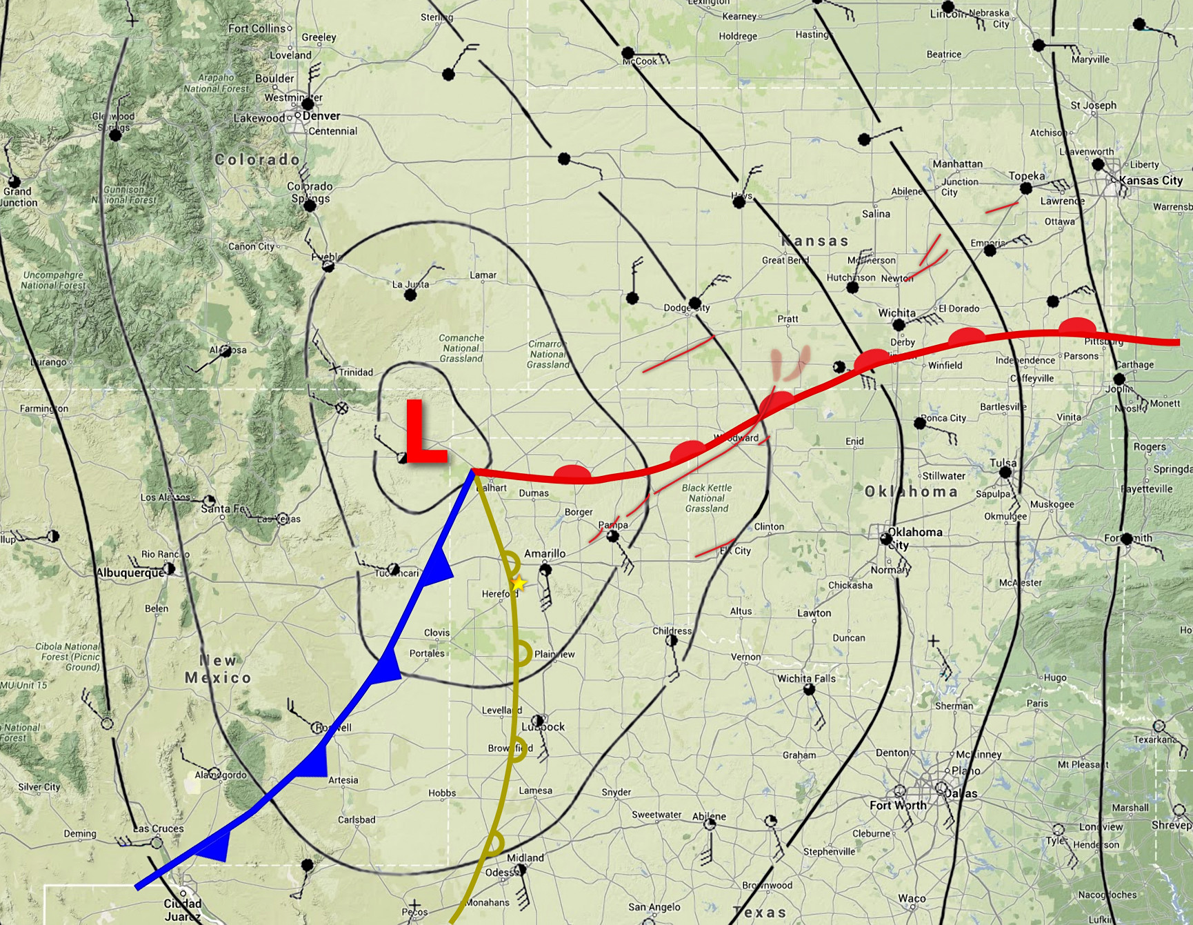
Once touted as the deadliest, most violent, longest tracked storm, the Woodward tornado has since been relegated to an honorable mention among the known F-5s. The 220 mile long damage path originating near White Deer, Texas finally ended it's deadly dance near Medicine Lodge, KS. This path was once thought to be a single long track storm but has since been proven to be a cyclical system with as many as six different tornadoes with the strongest portion being Woodward, OK. At 1.8 miles wide moving at an average speed of 50 MPH the storm destroyed countless homes and took 185 lives in the Texas panhandle and NW Oklahoma.

In the Texas panhandle the towns of Higgins and Glazier where heavily damaged, Higgins rebuilt and carried on, Glazier was abandoned and is still a ghost town to this day. In Glazier, TX two men seen shaking hands shortly before the storm hit where found in separate fields over 2 miles apart.

wwd47map.gif


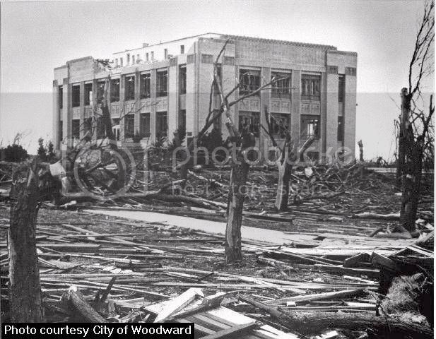
In downtown Woodward the theater was playing, "Rage In Heaven" the drive in was playing' "Devils On Wheels" and at 8:42 PM the storm hit the city destroying about 100 city blocks.

wwddmg1.jpg


This storm is especially significant to me since my family hails from the Pampa, Canadian, Higgins area and in 1975 we moved to Woodward, OK when my stepfather bought a business there. Growing up listening to the "old timers" talk about the incredible things that this storm did and every year on the anniversary the local radio stations would do something to commemorate the event. One year they played music from the '47 era and narrated as the event would have unfolded in real time along with eye witness interviews.

Returning to Woodward in 1982 after a stent with the US Air Force I quickly discovered that the tornado of '47 was still a hot topic and some local HAMs had decided to do something about it. With funding from the city, some private donations and the proceeds of countless bake sales Bill Wyatt KC5NZB managed to buy a surplus RADAR and the Woodward Severe Storm Center was born. Upgrading a few years later to a C-Band Doppler RADAR the skies over NW Oklahoma where scrutinized by this privately held sentinel for years until finally being supplanted by the WSR-88D network. The facility now stands abandoned at 36°26'28.63"N 99°22'17.28"W
 
So I've been working on a blog post about the Woodward tornado event, and I figured I'd share a bit of what I've learned so far. Obviously it was indeed a tornado family; so far I've been able to find evidence for at least four significant tornadoes. The first tracked for about 13 miles on the northwest fringe of White Deer, TX, followed by an eight-mile path north of Pampa, a 30-mile path west and north of Miami (may have been either a single long-track tornado or a series of two or three), and then the main event from northwest of Canadian all the way to north-central Woods County, OK. This also may have been a series of tornadoes, but I haven't gotten that far yet in my research. Some locals at the time thought that the storm cycled between Glazier and Higgins, but I have yet to find evidence for that.

Anyhow, the setup that day was interesting. It was a cool and blustery day, with a cold front having passed through from north to south a few days earlier and stalled out in Central Texas. Scattered rain showers and heavy fog prevailed over most of the Panhandle during the morning and early afternoon. By about mid-afternoon the sun began to break through, and the cold front surged back to the north as a warm front. Temperatures rose rapidly from the lower 50s up to the lower to mid-70s. Strong, gusty southeast flow brought abundant moisture (dews into the mid-60s).

The Woodward supercell initiated sometime around 4:00pm along the dryline just southwest of Amarillo. The supercell sort of reminds me of the 5/4/07 Greensburg storm for a few reasons. Although the first tornado near White Deer was relatively small (200 yards) and unremarkable, the tornadoes near Pampa, Miami and Canadian were apparently large (1+ mile) multivortex wedges, and each of them were joined by a number of satellite tornadoes. It's hard to make out exactly what happened with such little information available, but from eyewitness reports and mapping out some of the damage it does appear there were often several tornadoes on the ground at once, at times separated by a considerable distance. Possibly some of them could have formed along a flanking line or RFD gust front. Either way, it also reminds me of Greensburg in the fact that each of the large tornadoes curved cyclonically throughout their paths.

Interestingly, the supercell encountered the warm front at about the same time it began to produce the Glazier-Higgins-Woodward tornado, and in fact it may well have tracked parallel to and just slightly on the cool side of this front. This was also the case with the Tri-State tornado, 4/27/11 Hackleburg and a number of other long-track tornadoes, which may lend credence to the idea of a single long-track tornado impacting all three of those towns. Actually, there was very little temperature difference across the front by that point. Temperatures were a degree or two cooler on the "cool" side, but dew points were actually higher. Surface winds backed significantly as well. It wasn't until well after the tornado struck Woodward that it began to curve cyclonically and it encountered more stable air to the north. It weakened and dissipated well west of Alva, and then it produced a widespread area of downburst damage and possible embedded tornadoes in central and eastern Barber County, KS.

Made up a rough surface map for 22z. Gold star is roughly where the supercell initiated, and I've added all of the tornado paths that I could find. The tornadoes actually curved quite a bit, but it didn't show up as well on the map.

 
Hi Shawn, I notice GAG is missing from your map. I have the full set of GAG observations from that day filed away somewhere. I used them while researching Warnings: The True Story of How Science Tamed the Weather. Here is what made it into the final manuscript:

The classic supercell drops its heaviest rain and hail north of the path of the tornado (the tornado usually occurs on the southwest edge of a northeast-moving storm). This supercell was no exception, as half-inch hail began falling at the tiny Gage, Oklahoma airport at 7:28 (the first weather station that measured conditions around the supercell since Pampa). The winds became somewhat more east-southeasterly and gusted above 40 miles per hour. The barometric pressure at Gage, which had been dropping fast all day, went into a free-fall–so much so that the weather observer twice noted the rapid pressure drop. He also noted a “vivid” display of “continuous” lightning.

The tornado crossed out of Ellis County and passed south of the town of Tangier. Another person died. While the nine Oklahoma fatalities were a tragedy, the orientation of the track, and the towns along it, was such that the tornado missed the bulk of the population of Ellis County.

Just east of where the Santa Fe crosses Sand Creek, the railroad track takes a turn back to the east, and that’s where it reunited with the tornado: at the largest town in northwest Oklahoma, Woodward.


If you need the actual observations, I can dig them out for you. Good luck with your project!!

Mike
 
Hey Mike, that would be great! I'm just covering Higgins now and I haven't done much research on the Oklahoma portion of the tornado yet, so that'd definitely be helpful. I remember reading the chapter of your book on the Ruskin Heights tornado a while ago but I didn't know you wrote about Woodward as well, it sounds like a good read. I'll have to pick it up after I'm done.
 
Shawn, obviously every author would like everyone to read his/her book. I'm certain you would enjoy "Warnings." I can say that confidently because it is rated 5-Stars by both Amazon and B&N.

Let me start looking next week. Since we moved some of the offices I'm not sure where that file exists. But, I'll find it and get a copy to you.

Mike
 
This seemed like a great opportunity to jump in - Mike, my girlfriend bought me your book for Christmas, and it was a very good and informative read. I was especially interested to read about the Rector family (note my last name).
 
Shawn, in researching the path(s) of this tornado, please note that a farm just outside the small town of Shattuck, OK was destroyed with 2 fatalities. This was just east of the border with Texas panhandle. This is in the rural part of Ellis County, just southwest of Gage as Mike Smith referenced above. From what I have read, I tend to believe it was one long-track tornado, at least from Glazier to Woodward.
 
Hey Mike, you're probably talking about the Kolander home, where the mother and youngest child were killed. Another daughter, Ramona, was also initially not expected to live but she survived to tell the story. Several others were killed in Ellis County as well, including a few people in vehicles.
 
Hey Mike, you're probably talking about the Kolander home, where the mother and youngest child were killed. Another daughter, Ramona, was also initially not expected to live but she survived to tell the story. Several others were killed in Ellis County as well, including a few people in vehicles.

Yes, it was the Kolander home. I think the youngest child was a boy, though, as his name was Doug. Ramona had to run a mile to another farm house to get help to pull her father out of the rubble. This is from the book Storm Warning by Nancy Mathis.

I would second the recommendation to read Mike Smith's book, as he has a whole chapter devoted to this event. Fascinating.
 
Yes, the child was a boy, I just didn't word my post very well. I haven't read that book, but Ramona's story also appears on this Woodward County genealogy site.

http://www.usgennet.org/usa/ok/county/woodward/tales.html

There was also a short story in the Amarillo Globe a few days after the tornado, which is where I originally came across her story. There was another home not far from the Kolander farm that was swept from its foundation and scattered across the highway to Shattuck, causing people to detour out into a wheat field to get to the hospital. That must have been quite a sight.
 
This seemed like a great opportunity to jump in - Mike, my girlfriend bought me your book for Christmas, and it was a very good and informative read. I was especially interested to read about the Rector family (note my last name).

I have a nephew, Todd Rector, who lives in Chicago and works for the Trib. So glad you enjoyed the book!
 
I just finished my blog post so I figured I'd share it here. I didn't have time to proofread it, so I'm sure there are a few mistakes.

http://stormstalker.wordpress.com/2014/03/15/the-woodward-tornado/

That was a very interesting read, and quite detailed. You're a gifted writer and I encourage you to keep it up.

Intriguing comments about the unusual animal behavior hours in advance of the storm, and I'm sure we've all heard similar tales or even observed such. It would make for a good topic on its own. The only possible conjecture I have would be some kind of extra sensitivity to changes in barometric pressure.

One other trivial note - I'm not sure if the railroad running through that part of country at that time was the Sante Fe (AT&SF) or the old Katy (Southern Kansas railroad), as I've read different accounts. Perhaps both had tracks in the area, or both railroads shared the same track.
 
Last edited by a moderator:
Thank you, Mike. I found the animal behavior interesting as well. I'd have just written it off as a bit of exaggeration except that it was noted by a number of people in several different sources. I don't put much stock in it, though I know there have been studies that have attempted to look into whether animals can "sense" storms, earthquakes, etc. Birds in particular are said to be quite sensitive to pressure changes and often hunker down in advance of a low pressure system. Either way, it's an interesting anecdote.

With respect to the railroads, the Santa Fe is the one that was roughly paralleled by the storm from Amarillo to Woodward. The Katy, as I understand it, ran roughly north-south through western Oklahoma (from Wichita Falls up through Altus, Leedy, Vici, etc.) and then westward into the Oklahoma Panhandle. It did pass through Woodward, which might be where the confusion comes from.
 
What an amazing, well-written account, Shawn. Your words are very sense-rich and capture the mood so well; it's as if you had been there yourself. Very gripping indeed. Hope this gets published to a wider audience sometime.
 
Great work.

It's interesting that you mentioned Greensburg earlier in the thread, as there may be similarities regarding the low-level wind field as evening drew in. As we know, the low-level jet can often crank up in the evening as surface cooling causes the boundary layer to start to decouple. Usually this means the storms start to become more elevated as they draw air in from atop the boundary layer, but in some synoptic set-ups, where plentiful low-level moisture and instability is within the warm sector, low-level parcels can still remain buoyant, or at least buoyant enough for an established supercell to continue to feed on them. The strengthening low-level jet causes an rapid increase in low-level SREH, and hence the risk for strong-violent tornadoes across the Plains states *can* go up through the mid-evening hours in these set-ups.

For discussion on the Greensburg storm, with reference to low-level flow see https://ams.confex.com/ams/pdfpapers/141811.pdf?q=vortex-storm-chaser
 
Great account of this storm. The Glazier/Higgins/Woodward tornado has always fascinated me, mainly because of how ingrained it is in the memories of a lot of people out there still. One of my good friends is from Laverne and there are still people up there that talk about this storm after all these years because of how catastrophic it was for the region. It's also interesting to note the eerie similarities between this and the Greensburg storm. Two cyclic supercells that kept going well into the night producing multiple large tornadoes over a long track due to the enhanced low-level shear and a very saturated boundary layer in place.
 
FB_IMG_1491758559681.jpg I had the opportunity to head out to the TX panhandle a few years back and interview a survivor of this tornado in Higgins TX. I first stopped at Glazier and visited the old jailhouse (pictured below) which was one of the two structures left standing and the only one left from the original Glazier. I've read about people taking shelter in there and as I peered through the window, I imagined in my head people huddled down as that monster was just outside tearing apart that poor community. I then headed into Higgins and found a police officer who welcomed me into his house, made calls around town to find what survivors of the tornado were still living, and escorted me around town to find them! Finally, we found Leroy Koch (pictured above) who welcomed me in and talked to me for about an hour and a half about the tornado and his life in general. He said, "It blew like hell and then it got quiet, then it was on top of us." His father had a vice bolted onto a table in the garage. The tornado ripped the vice off but left the table. It lifted their Model A Ford up and set it upside down. He talked of the aftermath and how the town never fully recovered. He pointed out how the buildings in town had bricks from before the tornado and bricks from after. He told me of his military service and shed some tears. He talked of his love for his family. As he did, a storm brewed outside out of no where and a little whirlwind formed just outside his window. Chills down my spine thinking of it! He passed away in 2015. On a chase in the TX panhandle this spring, I visited his grave in a secluded cemetery and laid flowers on it. Rain drops started falling on his headstone. A storm I had been following started coming together and moved directly overhead and there was a rumble of thunder. Chills down my spine again FB_IMG_1491758551003.jpg .
 
Back
Top