12/14 - 12/15 SNOWSTORM: GREAT LAKES

Tim Gonyo

EF2
Joined
May 28, 2005
Messages
131
Location
Saukville, WI
Looks like things could get interesting during the middle part of next week. Comments guys?

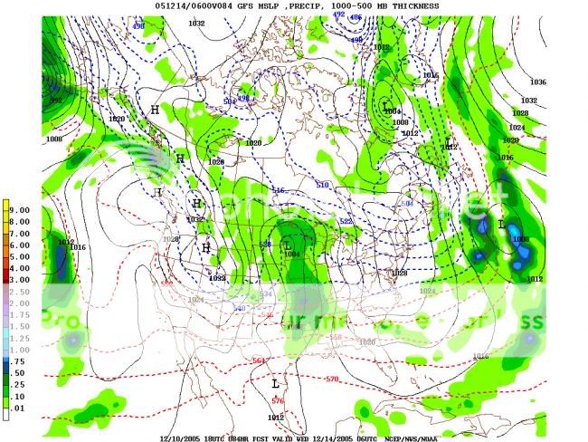
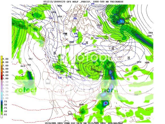
Here's the AFD out of KMKE.

AS FOR MID WEEK SYS...CANADIAN DEVELOPS QUITE A STORM FOR WED
WITH A FAVORABLE TRACK FOR SRN WI. DGEX SHOWS MORE OF A GULF LOW
PULLING OUT TO THE NE...WHILE ECMWF AND GFS SHOWING MORE OF A
PROGRESSIVE LOOKING UPR SYS ACRS NRN TIER OF STATES. WITH
THE LACK OF CONSENSUS AND LACK OF RUN TO RUN CONSISTENCY WITHIN
THE GFS POINTS TOWARDS KEEPING CHANCE GOING FOR WED/THU TIME
FRAME.
 
"Comments guys?"

Yep. Since no model had last night's half-foot+ storm until 48 hours prior to the event, I'd put a non-consensus, not-supported-by-ensemble outlook 5 days ahead on the backburner.
 
The 12Z GFS is leaning more towards the 00Z GEM solution... Right now, the key is to just look at the patterns and ensemble solutions, not much else you can do right now. As Rob said, I will put this on the back burner and re-post in this thread when the storm system seems a bit more likely - provided it's still targeting the Great Lakes.
 
I will keep it in the very back of my mind to say the least until it's nearing 60hrs out.

The run to run differences are still ridiculous with this storm. Add in some possible negative feedback issues with snowpack, and possibly adding a little more to it before the storm hits, makes for a very low confidence outlook.
 
OK, just as a note, I am using all 18Z runs of the American Models and the 12Z of the EURO...

Please ignore precip on all maps.

Lets start at the NAM:

12151.jpg


GFS:

12152.jpg


Surface map of Jan 2 1999:

12153.jpg


Look at the placement of the Highs and Lows that I have outlined...

Notice anything similar?

With the exception of the weaker pressures, this is setting up to be almost exactly the same.

Lets move down the road to 120hrs away, Low #1 and 2 have merged:

GFS:

12154.jpg


This is much weaker with everything across the board, so thats why I its placing the GL low so far north, but you still get the idea.

Here is the Surface Map:

12155.jpg


Still very similar...

Notice those 3 high pressures, If we can get those highs to be as strong as 99, I would bet money that we would have a repeat of the 99 blizzard. The EURO is very good on representing this, as you will see.

And to close my discussion about these 2 storms, The EURO:

12156.jpg


"The Ghost Of The 99 Blizzard"

This is disturbing...I received 24.5 inches of snow in southern WI on 1/2/1999 with intense thundersnow for awhile....and 65 mph wind gusts.
 
It is interesting. I'd like to see what the upper air patterns looked like for the 1999 storm to really see if there was any similarity. My guess is that the 500MB shortwaves and upper level jets were more amplified in 1999... Then again, the 1999 storm didn't really deepen all that much (996MB as it passed over lower MI).

Anyway, this event is still a ways out AND model continuity is pretty poor right now. I'd wait until the event is at most 60-72 hours away and well captured by short term models.

I really hope something happens... I can't stand the cold without anything fun happening.
 
Lots of low pressure and high pressure setups look the same - but you need to use much more than a surface plot. How's the jet stream in comparison? What did 500mb look like then vs forecast now?
 
Lots of low pressure and high pressure setups look the same - but you need to use much more than a surface plot. How's the jet stream in comparison? What did 500mb look like then vs forecast now?

I couldn't find any 500MB data - but Unisys has an archive of the 4-panel plots (SFC, 850MB, 300MB, and LI). From the 300MB plot, I gather that there were two very seperate shortwaves in 1999, with the lead shortwave being in the southern stream. The southern stream shortwave was located over southern TX, while the northern wave was located over northern MT.

With our current system, it looks like the dominant shortwave will turn out to be the northern stream wave, but that could change. Also, the models are very light with QPF - that's another difference between these two systems.

With the 1999 system, I remember watching it when it was 7 days out on the "MRF". The system seemed to get "lost" as the event got closer (it was completely gone in the day 4 to day 5 timeframe), but then reappeared. I also remember that 6HR model QPF for a big chunk of land was 0.50 to 0.75 inches. Our current system doesn't seem to carry QPF that high.
 
I wouldn't bet money on anything. January 1999 was an interesting phasing of two systems that evolved into one significant extra-tropical cyclone (I remember it well, we were *supposed* to get 10" in Kansas City and we ended up with maybe an inch)... the interaction of two systems is never "given"... The interaction is dependent on so many things and you can either end up with one significant vorticity max that allows the development of a robust surface cyclone/anticyclone couplet supporting ingredients for possible blizzard conditions.... or you can get a sort of fuji-wara of two vorticity maximas that end up rotating around each other... and you get two surface responses close to each other.. destroying your good pressure gradient for a significant and widespread snow+wind event... right now I see the ecmwf and gfs favoring more the latter. In fact there will probably be three disturbances at play here... and if they don't interact in the "perfect way" you just get a messy, disorganized winter storm with some snow and maybe a little wind... with a 1000 low here, a 1009 trough axis there, and a 1027 high to the west... To get a major blizzard, there needs to be incredible anticyclogenesis OR cyclogeneis to get the strong pressure gradient, of course.... right now I just see "decent" cyclogenesis and a poor signal of robust anticyclogenesis or absence of a huge arctic 1040+ high in close proximity to the north or northwest.

This is why predicting blizzards is extremely difficult. It takes a very delicate balance of ingredients with cold air, moisture, jet streak dynamics, etc etc etc... on all atmospheric scales... which I honestly say we can't predict easily at all even 2 to 3 days in advance... So I put my money on a wait and see :) Models right now are changing so much... just look at all the little purturbations on a north american water vapor loop right now... it's extremely chaotic.

If you can say explosive deep tropospheric cyclogensis will occur with a singular dominant h5 vort center, with one dominant mid-upper jet streak involved allowing just one surface cyclonic/anticyclonic couplet to vigoroustly develop at h+120... then you are a better forecaster than I am :)

Mike U
 
Models right now are changing so much... just look at all the little purturbations on a north american water vapor loop right now... it's extremely chaotic.

That's for sure. Not only do the models not handle phasing all that well - but with the shortwaves still over the ocean, I doubt they were well sampled.

As of right now, I'm not really "feeling it" in terms of a big snowstorm or blizzard... In other words, my hopes aren't high at all. But then again, even if the majority of the models DID have "the storm of the century", my hopes still wouldn't be that high. The fact is, with the system still being a solid 84 to 102HR's out, things WILL change.

FWIW... The latest NAM and GFS show two seperate shortwaves at 500MB exhibiting a slight Fujiwara effect that Mike U. was talking about.
 
Some pretty big differences right now just between the NAM and GFS. At 78hrs, the NAM has the 850 freezing line in central WI, while at the same time the GFS is in southern IL!!
 
Now that the system is nearing the 60hr mark, I guess it can be taken more seriously now, well at least for me lol. The GFS and NAM have become a little more similar to each other than previous runs. The NAM still has a small wedge of warm air ahead of the main trough, just above the surface, but is much less bullish on the amount of warm air compared to previous runs. The GFS has been the most consistant.

The bottom line is, this whole storm system looks to be pretty complex, so there's still a very good chance certain issues won't be resolved for another 30-42hrs.

If we can close off a decent low at the southern end of the trough there could be quite a snowstorm for someone, but right now that doesn't look like it's going to happen.
 
Models seem to be coming into BETTER agreement... But as you said Joel, there are still some small differences (small differences in terms of placement, timing, evolution - the "better" agreement means that we are all on the same page with a storm, LOL) that will have a big effect on what ultimately happens. I'm really liking how the models are trending towards a single vorticity maximum, versus three. I'm also likeing the less-progressive system, so areas that do see snow will see a longer shot of it.

There are still two main SFC reflections though - one in the MS Valley and one near the Gulf. If we can get those to phase a bit further south or at least the southern wave ride north along the slow moving baroclinic zone / front, someone may be looking at pretty heavy snowfall. Not really concerned about blizzard conditions at this moment in time, but heavy snow looks like a possibility for someone.

Reading over NWS discussions, DTX mentions that various snowfall techniques are showing 6-8 inches at a 15:1 ratio, with the potential for convective snow. Obviously that's not the forecast, just sort of a "what if" situation.
 
Back
Top