02/28/2007 REPORTS: KS / MO

Joined
Oct 6, 2006
Messages
16
Location
Iola,Kansas
Intercepted the Torn Warned cell coming out of Woodson County at dark, drove from Iola to just north of Colony on US 169, looked to be a large wall cloud to the west, received a call that there was a reported wedge near Neosho Falls moving east, moved back south on 169 to 4 miles south of the Allen/Anderson County line. Observed a stovepipe, then 3 seperate tornadoes, then multi-vortex tornado, morphed into a wedge right about the county line. The meso on this storm was huge, wrapping around for about 1 mile and a half. I understand that several homes and outbuildings were damaged in Colony, but no injuries reported. One of my fellow fireman is from there and his grandfathers farm sustained damage. I will try to go see the damage path on friday as i have to work tomorrow. Thank you to Mike Parker,Corey Isbell and Gary Kimball for the nowcast updates and getting me out of the cave, i beleive the tornado passed by the hill where i was sitting be fore i moved back south to Allen County. Daylight Saving time cant get here fast enough.
 
I to intercepted the torndo warned cell in Woodson County. I observed the wedge near Neosho Falls and another large tornado in Allen county, not exactly sure where. I also observed one of the most incredible lightning shows of my life south of Ottawa, KS. An awesome chase except it was in the dark.

Will post a chase log ASAP.
 
I intercepted the tor-warned cell west of Butler, Missouri and observed a tornado to the west of Adrian tonight, with a second tornado north of the small town of Urich. I had stopped in Adrian on my way to intercept and initially went west there. I went into a gas station and told an attendant that a supercell was headed her way and to think of places she could take cover if she needed to. Then I moved south to get under inflow and watched an enormous (I mean huge) meso with several funnels, and finally what appeared to be a tornado (hard to judge ground contact at the time with the lightning as it was). I backtracked to Adrian and took hwy D out of town, then north on BB to 18, with the enormous meso in perfect view the entire time. After getting to a little town called Urich, another tornado appeared to be on the ground north of town. It was a long slender, twisted rope. As I got up to the area where I had seen it, I ran into what had been the track of the hail core of the storm, with about an inch of fresh, steaming hail on the ground. Size was 1.5-2" ... I stopped and took a few photos (the hail fog was AMAZING), and then I ate two pieces of hail just because I wanted to eat something that had just been 50,000 feet in the atmosphere. Starting back toward Harrisonville ANOTHER supercell, with ANOTHER amazing meso. Low wall cloud again. I couldn't tell through the lightning and scud, but there very well could have been a tornado northeast of Harrisonville. It sure looked right for one there.

I just got home to torrential, horrible rain, six inches of water standing in my basement, and hail like you wouldn't believe. The hail is currently coming down my chimney into my fireplace and bouncing across my living room floor.

I won't forget this night anytime soon. Two classic supercells (these were good old, mama jama huge size, classic storms ... none of that mini stuff). They were easy to chase (like 40 mph), well lit most of the time, and downright fun. Pics tomorrow ... though don't count on anything special. Had a tough time with the photography. I'm anxious to see what came out.

Edit: here are a few photos. The lightning just would not cooperate with me on the stills while the tornadoes were going on. But I just checked video, and I do have some great shots of the tornado that I'll have to freeze tomorrow sometime. cool -

Initiation over Olathe at sunset - you can actually see the anvil on the Iola storm on the extreme lower right):
webCRW_0993.jpg


Storm tower over Olathe from the east. After this shot, I made my post to the NOW thread and then booked south to intercept the big boy.
webCRW_1015.jpg


Meso on Adrian supercell. I'm only including this because it shows how enormous this meso was.
webCRW_1119.jpg


Tornado. (yeah, bad shot ... it ain't May yet)
web1136.jpg


Hail north of Urich.
webIMG_1154.jpg


There were chunks bigger than this, but I needed to get moving because there was another supe coming in from the west.
webIMG_1156.jpg


Edit - just a quick update with a few vidcaps. Had been waiting on a part for my computer.

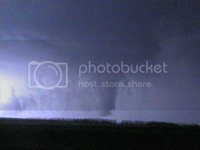
Tornado taking shape southwest of Adrian:

AdrianTor1.jpg


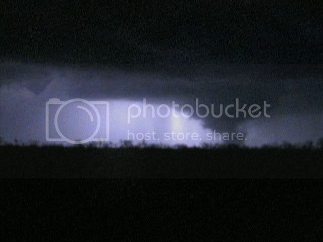
Powerflash on the ground SW of Adrian:

PowerFlash.jpg


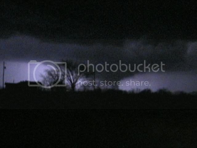
Wall cloud formation east of Harrisonville:

HarrisonvilleWC.jpg


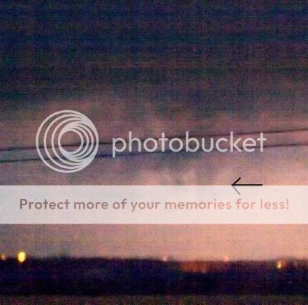
Funnel east of Harrisonville:

Harrisonvile3.jpg
 
Last edited by a moderator:
I got in late on the Osage-Coffey-Lyon storm sitting here at home looking at the TWX and intellicast radar I watched a hook echo form at the Lyon-Coffey line near I35. I was getting in the truck when the sirens went off in Osage City. Intellicast showed a TVS on their radar summary for several minutes before TWX issued the warning.

Went S. on K170 and ran into pea-quarter sized hail 3 miles W. of town. Everything was so rain-wrapped I hesitated to go too far South until I had some radar data which OS CO SSO was broadcasting on their dispatch frequency. The best I had was a wall cloud that moved well into Franklin county as I was driving East from the NW side of Melvern lake.

This is some of the freakiest weather I've seen in 20 years of being a spotter. Good chance I'll wake up tomorrow with snow on the ground. Oy Vay!

JH
 
I was on the long track tornadic supercell as well... hectic and sobering experience. Left KC at 325pm and got down to Buffalo KS just as a couple of young high-based hailers were rocketing NNEwd. A single supercell emerged and someone "flipped the switch" about 610pm; the storm turned nearly due east, and developed an amazing collar cloud and wall cloud which had violent rotation within minutes. Beautiful coloring on these features with the twilight. The roads rather sucked northeast of Yates Center and I got out of position on gravel. Meanwhile the storm developed strong HP characteristics with a very large wet RFD... and a monstrous inflow band as well. Became very confused around the small town of Colony... couldn't hardly see anything in the way of identifiable structure, while reports of tornadoes came over the radio station. Proceeded cautiously eastward through Colony when a multiple-vortex tornado suddenly formed a couple miles ahead of me. Lost the tornado temporarily while maneuvering around downed powerlines and barbed-wire fences in the road... and when I regained site of it by 716pm it was a shape-shifting wedge/multiple vortex barrel off to my northeast. Got out of position again about 725pm, when the moon (nearly full) came out from behind the supercell's anvil. Reacquired a view of the RFB by 735pm and saw only the ragged wall cloud and no tornado. But after crossing into Linn County KS, the tornado was back... in fact there appeared to be two tornadoes on each side of the wall cloud. By 740pm the tornado morphed into a solid monstrous wedge in lightning flashes to my northeast, resembling the 1976 Jordan IA wedge nearly to a "T." Headed north of Blue Mound and got within a couple miles of the tornado when it rapidly dissipated around 750pm. Encountered a large building strewn across the highway 5 miles north of town. The LEO and firemen there informed me it was a house, and that blessedly no one was home. Pretty much ended the chase here... encountered amazing hail fog when I crossed the supercell core's path on Highway 69 south of Louisburg. I'll have pix and an account up in a few days.
 
Had the forecast nailed today but opted to stay home (Doh!!) as I was a bit late getting out of work tonight. Got home and saw the monster supercell down south split and turn right as it moved east across N.Woodson and S.Coffey Counties. Got some take out dinner and came back home...and got hailed on...again...and again..and...at total of 7 times (so far tonight) here in Overland Park near the 435/35 interchange. We had hail of quarter sized and smaller. This was outrageous and I cannot remember any other time in my life I observed this. The warm front seemed to be the "railroad tracks" for the meanest of the supercells to move along. We seemed to be stuck in the zone for the elevated hailers in the SW suburbs of KC.
 
Thank you Dick McGowan, Matt Jacobs, and Jeremy Goodwin for the nowcasting!

What a crazy night it was. Doug Mitchell, Josh Berg, and I were on the long track supercell that pretty much everyone else was. We intercepted the storm about 10 miles west of highway 169 and soon a big wedge came into view. I second guessed myself because I wasn't expecting something that big to emerge. We then headed back east to Colony where we saw the tornado that hit the town form on the east side of town while we were watching it from the west side about 1/4 of a mile away. We then followed the storm east and saw a multiple vortex tornado form probably a mile to our E/NE. The next part is where the chase got edgy because we turned a corner to go north about 4 miles east of Colony and discovered that we had turned and driven on powerlines even though we didn't notice them until we saw the poles laying across the road(Don't follow the path of a tornado at night because it's hard to see things like that) . We managed to get out of harms way but had to back track through Colony seeing debris scattered all over the place from the tornado. We did watch the tornado morph into a larger tornado as it moved away from us but that was on the back of our minds as we were trying to get out of the danger that we were in. That pretty much cost us our position on the storm because we had to back track so far. We then played around with the second storm south of Ottawa but never managed to see anything that was really worth of noting.

I hope that everyone came out ok that was affected today. I have a feeling that a lot of people were caught off guard because it's so early in the season.
 
Last edited by a moderator:
Mike, that's not so bad after you look at this ;) This is the beginning stage of the multi-vortex that formed east of Colony. I tried to jump out of the car and use it as a tripod so we could keep moving but it didn't work out too well. Shortly after this is when we got split off from the storm because of damage so I didn't get a chance to redeem myself. Oh well, hopefully the video is better.

multivortex.jpg
 
Here are some pictures from the developing wedge northeast of Colony, KS. It was a miracle this supercell did not produce a tornado before sunset...Increidble structure!

During a lengthy lightning flash, the initial stovepipe reminded me of the May 29, 2004 south KS stovepipe near sunset.
feb_28_tornado1.jpg


feb_28_tornado2.jpg


feb_28_tornado3.jpg
 
While everyone was out chasing their tornado warned cells and whatnot, we drove a few miles after the separate NW cell that passed by Salina just because it was only a little ways from where we live.

Other than some decent lightning not much came of it, just a little rain...but it gave us a good chance to test out our wxworx and gps.

Congrats to everyone who had a good end of February chase.

Caleb
 
I was on the tornado warned cell moving from Woodson Co, KS into Anderson/Allen Co. I first saw the tornado aprox. 1 mile WSW of the town of Colony, KS. From my observations of the tornado, it initially was a wedge with "possible" satellite extending out to the west. As it moved East toward Colony the wedge lifted and turned into a multiple vortex with as many as three separate areas of rotation. These tornado's would lift and then go back down as they passed the town of Colony. After the meso moved East of the town it wedged back up. At that point I got out of position and lost the storm to my NE. Thank you Dick McGowan and Ann Money for the nowcasting and thank you Eric for moving South. That could have been nasty.

I am sorry for the image quality of the following video grabs. I am just learning how to to video editing so it is what it is. The sequence below is from initial wedge WSW of Colony to multiple vortex to re-wedge East of town.

Initial wedge
WEDGE.jpg


Starting to go MV
GMV2.jpg


Going MV
GMV3.jpg


MV
MV7.jpg


About to go back wedge
GBW10.jpg


West of Colony wedge
GBW11.jpg


Here is a blown up version of Multi Vortex
multiplevortexlg.jpg
 
Last edited by a moderator:
Nothing much to report.... Dan Dawson, myself, and a couple others decided to try our luck with any convection that developed off the dryline in central and northern Oklahoma. We left OUN around 3:45pm and headed NNEward where satellite was showing enhanced Cu north and northeast of OKC. It didn't take very long for that field to dissipate, and, by the time we made it to Stillwater, the sky was clear. Oy. Of course, by that time, we noted two cells developing in southern Kansas, but quickly realized they were too far away. After eating at Eskimo Joes in Stillwater, we figured we'd check out the situation once more before heading home. Much to our surprise, the 01z SWODY1 upgraded most of eastern Oklahoma east of the dryline to MDT risk. We weren't much more confident in initiation after reading the SWODY than we were before reading it, but we decided to wait it out in Stillwater just a little longer. The 00z OUN sounding was nearly uncapped (though showed a little bit of drying above the surface), but there wasn't a whole lot of convergence along the dryline. Regardless, we were resilient and had fun drooling over the southeastern KS supercell that seemed to be a prime example of a tornadic supercell (with reported wedges and strong/violent tornadoes) in low CAPE (mesoanalysis was indicating <250 j/kg for a while, with high CINH). By 10pm, convergence was quite strong along the cold front that was overtaking the dryline, so we waited. And waited. By about 11pm, a blip we noted just WNW of Stillwater actually developed into a storm, and we were off. Not entirely surprising given the degree of forcing/convergence and the apparent CINH, this convection quickly "lined out", and we gave up chase east of Pawnee since we didn't want to chase a highly-forced, narrow squall line after dark in northeastern Oklahoma (with deep-layer shear vectors 45degrees off the cold front and 80-90 degrees off the dryline, we had been holding out a little bit of hope that we'd see discrete activity).

All in all, it wasn't a terrible chase, though we're 0-for-2 in terms of potentially significant events in Oklahoma. I'm still amazed at the supercell(s) that developed in eastern KS and nw MO last night... I remember laughing with my advisor when looking at the 20-40F dewpoints along the OK/KS border in the early afternoon yesterday. Given the time of year and questions about moisture and initiation, we didn't want to make a drive to southeastern Kansas when areas of Oklahoma looked nearly as favorable, a decision supported by the RUC (which initiated precip along I44 by late afternoon) and the NAM (which showed precip north of Stillwater and into southern KS). The 20z OUN sounding pleasantly surprised me by indicating much deeper moisture than I was expecting given the veered flow that existed near 850mb, and I thought it was more likely that moisture depth farther north to the OK/KS border was considerably lower, a 'guess' that I used, in part, to justify not driving to KS. It sure would have been nice to have the 57-62F dewpoints widespread east of the dryline as the NAM had forecast. Ooops.
 
Target was orignally was around the Tulsa area, but soon decide to relocate to the north. We were able to catch up to the Colony, KS storm right at sunset near Yates Center, KS and were able to ride a due east rode that ran parallel to the storm most the way to MO. The storm was simply amazing. We stayed directly to the south/southwest of the storm within about 10 miles of it till the roads got bad. There was no rain rap around on this storm till it got close to the MO border, which was one thing that made this storm so chaseable. Lightning also kept the storm illuminated very well. Most of SE Kansas seemed to without power as this storm passed. There were countless power flashes as this storm tracked toward MO last night. I lost some of our closest footage we had, which happen to be when it was its biggest, because my lens cap was left on for a 15 min period. That was the only bad part of this chase for me. Here are a few stills.

North of Yates Center
DSC_0034small.jpg


Looking East towards Colony
2_28_20077_01PM_00011.jpg


Somewhere east of Colony
2_28_20077_12PM_00011.jpg


Another pic east of Colony
2_28_20077_11PM_00013.jpg
 
Sorry about taking so long to post. My summery is the same as Wes's (because I was in the same car) but I had my lens cap off for the tornado NW of Blue Mound. First photo is the multivortex and then the second and third are of the wedge.
 

Attachments

  • 3.jpg
    3.jpg
    11.4 KB · Views: 122
  • 6.jpg
    6.jpg
    13 KB · Views: 123
  • 12.jpg
    12.jpg
    12.7 KB · Views: 137
Back
Top