As we saw last year, the climo heart of the NHEMI TC season is being taken out w/ unusually low activity. Yes, we know what happened later in Sep and in Oct in the Atlantic last year, but the pattern is much different than last year (we don’t have nearly the anomalous warm SSTs in the Atlantic, as one example).
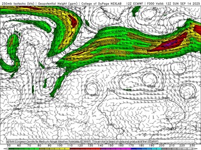
The overall pattern in the MDR in the tropical Atlantic has been quite unfavorable this season thus far w/ lots of Saharan dust and dry air present. Now, TUTTs (tropical upper tropospheric troughs) reign supreme in the next week w/ the peak of the season climo in the next 10 days. See the ECMWF 250 mb forecast valid 00z Wed and 12z Sat this week I attached. I outlined the TUTTs, and these being present typically puts the brakes on TC development.
And outside the MDR in the Gulf and western Atlantic, it is no better. A persistent trough in the eastern U.S. has resulted in a jet/high shear across these areas, so no dice here either UFN.
The global models have suggested the wave coming off Africa currently may develop, and the 8/31 12z GFS and ECMWF showed a hurricane eventually recurving out to seas in the Atlantic, but the 9/1 00z ECMWF has backed off significantly, showing at best a weak TS through 10 days. The 00z GFS continues to show a hurricane, but the GFS has a serious bias in over-intensifying waves into hurricanes in the long range and spinning up TCs out of nowhere beyond a week. It has had this bias for years, so it should be discounted at this time. The fact that the ECMWF backed off, and the GDPS is similar to the ECMWF, seems to suggest they recognize the hostile conditions in the Atlantic currently and for the next week, so I would go w/ their idea concerning the handling of the wave off Africa now.
I attached the 2025 NHEMI TC stats through 8/31.
It should be noted that in the 5 years 2020-2024, 4 of those 5 have been significantly below avg for global ACE (less than 80% of avg) w/ only 2023 being a bit above at 109%. We are now heading for 5 of 6 years significant below avg. I would argue this is something that should not be ignored.
What prevent TCs from developing/getting intense is just as important as to what promotes them! But the current prevailing mainstream narrative largely shuns this important aspect of TCs as to pertains to climate change.
Sure, the Atlantic has been very active in recent decades, but as I have mentioned before, there is world outside the Atlantic basin and the Atlantic only accounts for 15% of annual avg global ACE. Cherry-picking has been going on here using the Atlantic as "proof" of worse conditions. If one is to talk about climate, it needs to be looked at on a
global scale, not only local areas that fit one's predilections.
The 2025 NHEMI season has been less than stellar so far. The Atlantic is the only one close to avg, all others are below. Yes, numbers of named storms in the NHEMI so far is a bit above avg (34 vs. an avg of 32), but the stats that count, such as hurricane days, major hurricane days, and ACE (accumulated cyclone energy) are significantly below avg. NHEMI ACE is only 56% of avg season-to-date. This one reason why merely forecasting number of named storms doesn’t cut it as to telling the complete story. All the named storms in the world mean little for ACE if they are largely short-lived and weak. ACE is the best metric since it weighs heavily toward intense TCs and how long they remain intense.


")