Typhoon Chanchu

Joined
Jan 8, 2006
Messages
444
Location
West Hollywood, CA
Here's a rather interesting development:

Typhoon Chanchu, in the South China Sea with 115-kt winds, is expected to turn N and strengthen over the next couple of days as it heads toward China.

The latest JTWC forecast is alarming: the 17 May 12Z fix has the center just SSW of Hong Kong and moving N with winds of 125 kt-- Cat 4 (USA). This track would expose the densely populated city to the severe right-semicircle. That would be quite interesting, to say the least.

Definitely something to watch over the next 72 hours.

Please note: These images will update dynamically and the commentary above will no longer apply as time passes.

wp0206.gif


rb-l.jpg
 
This is indeed very alarming and quite eerie given that this seems to be the exact scenario played out in Discovery Channel's "Perfect Disaster" series just a few weeks back. :blink: Same forecast strength, same direction of approach, same everything. If this really does play out like it probably will, it could be a very, very bad situation for Hong Kong, especially being in the right front semicircle. With the city being so densely populated, evacuating everyone would be impossible, and a lot of Hong Kong's poorest sections are close to or at sea level. It wouldn't be unreasonable to say that at least a few hundred, if not a thousand or more people could die if Chanchu makes a direct hit on Hong Kong :(
 
JTWC upgrades Chanchu to 130 knot winds, well ahead of intensification schedule, and peak intensity is now forecast at 145 knots! The storm is now forecast to make landfall at 135 knots which is the threshold of Category 5 intensity on the Saffir Simpson scale.

This could be a typhoon of unprecedented destruction not only in Hong Kong but possibly around the globe and it has its bullseye aligned on Hong Kong. I don't know what will happen to the numerous high rise buildings and the 6.9 million people that live there but it cannot be good. :(

Check out the NHC enhancement of this:
http://cimss.ssec.wisc.edu/tropic/real-tim...m/dvor-nh11.GIF
Wow, talk about a donuty core of real cold cloud tops.

This now has my full attention. Just posted on it in my blog.

Sad.
[/b]

Indeed this is incredible. I foresee global headline news in this respect over the next few days. Intensification imminent, cat 5+, HK a direct target. I am looking at a flight to HK as we speak. The Plains downtime has given me a window of opportunity.

Mark
 
I didn't want to blow the whistle too loudly and be an alarmist about this, but it does look like a truly remarkable situation setting up.

The recently updated JWTC forecast still takes the center on a worst-case track for Hong Kong-- just left of the city-- and the final center fix prior to landfall indicates 135 kt-- a top-end Cat 4 (USA). If this forecast verifies-- and the right-eyewall of a 135-kt typhoon passes directly over Hong Kong-- this will be one of the most destructive global meteorological events of the last 100 years.

A truly remarkable set of circumstances here...
[/b]

There is quite an abrupt turn to be made yet if HK comes in the firing line. It may smoothen somewhat and give HK some relief.

Mark
 
There is quite an abrupt turn to be made yet if HK comes in the firing line. It may smoothen somewhat and give HK some relief.

Mark
[/b]
Very true. As of the latest JTWC statement, it is still moving W at 6 kt. However, they seem to expect a sharp, hairpin turn to the N at any time. It's interesting to think that the precise timing of this turn could have global economic impact.

My business partner freaked out this evening when I informed him of the threat to Hong Kong-- he thinks a direct hit by such a severe storm could have global consequences. I'd tend to agree.

So... are you heading there to chase it?
 
1. SUPER TYPHOON 02W (CHANCHU) WARNING NR 025A CORRECTED
01 ACTIVE TROPICAL CYCLONE IN NORTHWESTPAC
MAX SUSTAINED WINDS BASED ON ONE-MINUTE AVERAGE
---
WARNING POSITION:
141800Z --- NEAR 13.8N 115.4E
MOVEMENT PAST SIX HOURS - 260 DEGREES AT 06 KTS
POSITION ACCURATE TO WITHIN 030 NM
POSITION BASED ON EYE FIXED BY SATELLITE
PRESENT WIND DISTRIBUTION:
MAX SUSTAINED WINDS - 130 KT, GUSTS 160 KT

Mark
 
Next warning update in a little over 3 hours. I think the discussion is updated then too. Guidance appears to be clustered around HK still...
[/b]
Hey Alex, thanks for posting the model guidance. It does appear to be pretty tightly clustered.

Are you referring to the next JTWC warning, or a different agency?
 
Hey Alex, thanks for posting the model guidance. It does appear to be pretty tightly clustered.

Are you referring to the next JTWC warning, or a different agency?
[/b]

JTWC warning, I believe it is updated at 0300Z and I think their forecast discussions are issued at 1500 and 0300Z. Correct me if I'm wrong, I'm new to their procedures...
 
JTWC warning, I believe it is updated at 0300Z and I think their forecast discussions are issued at 1500 and 0300Z. Correct me if I'm wrong, I'm new to their procedures...
[/b]
Me, too. ;) I'm not entirely clear on how it works.

I am of course solid on the Atlantic basin, and this year I educated myself on the Australian tropical-cyclone scene (including how the Australian BoM works)-- but the South China Sea is totally new turf for me and I am not entirely aware of what other English-language information resources there might be.

The issue with the JTWC is that they just don't update nearly as frequently as one would like for a big event like this.
 
Here's an early-morning visible shot (which will dynamically update). The system is impressive, though not entirely symmetric-- and the center is not totally distinct. Is that some dry air wrapping into the circulation? The JTWC puts it at 130 kt.

Please note: This image will update dynamically and the commentary above will no longer apply as time passes.
vis.jpg
 
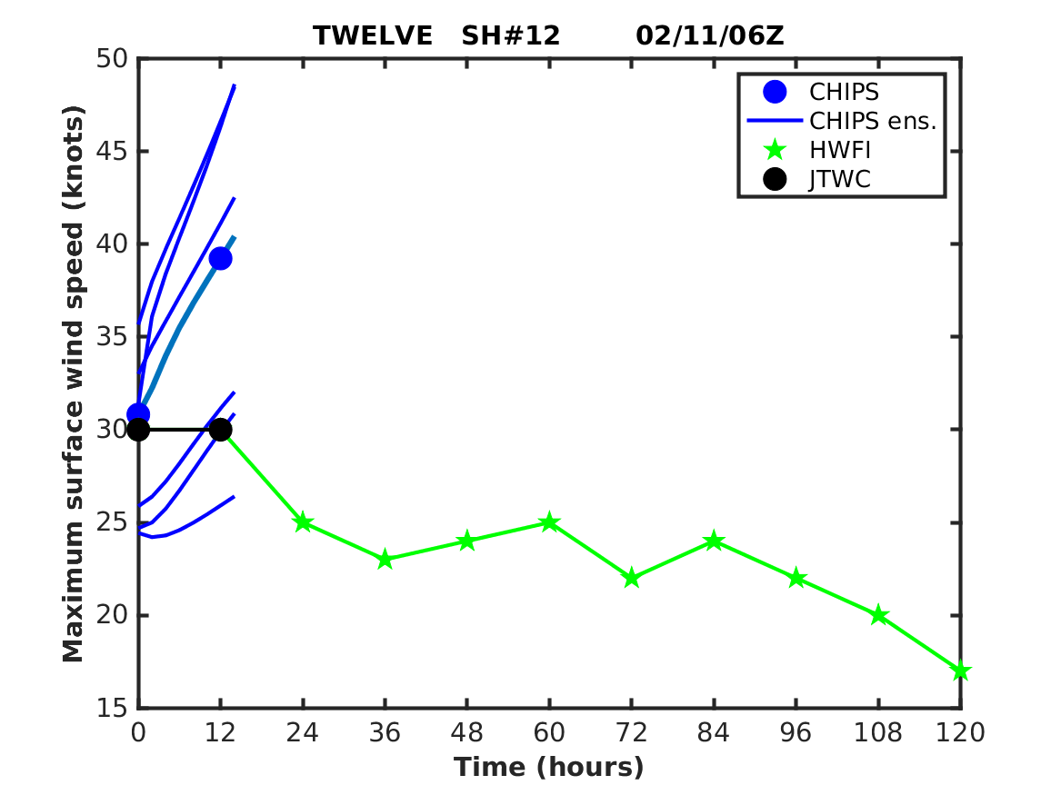
Latest Intensity Forecasts:
temp1.png

I guess we will just ignore CHIPS like we had to do with SHIPS during most of 2005.

Make sure to check out the latest Morphed Microwave Imagery from CIMMS:
http://cimss.ssec.wisc.edu/tropic/real-tim...sBy12hr_07.html


The MIMIC (IR) also shows a nice intensification that was continuing as of 2230 UTC (even though the eye has become obsecured). The eye has tightend significantly from this morning and shows very cold cloud tops surronding it. Shear is very weak with just 5-10kts and the 18z Global GFS hasn't changed much and the trough trough in China still seems to be moving at the same speed bringing about a turn of the cyclone. The NCEP Cyclone track perturbed ensemble members seem clustered to the right of the GFS solution probably weakening the sub-trop ridge a little more than expected. The track consensus looks pretty good for this range though I wouldn't be suprised to see a shift with the amount of time still left. I did notice that the offical Hong Kong Tropical agency's track is east of most global members SEE HERE: http://www.hko.gov.hk/wxinfo/currwx/tc_0603.png. As of 2z the Dvorak IR is showing some warming in the eye though it's still pretty obsecured.


I'd be really concerned if this track holds true as NOGAPS wave forecasts are for 32ft max (this from a model which is not great with intensity.) Also the WAVE MODEL (WAM) is equally as grim forecasting 26-36ft sig wave heights. https://www.yoko.npmoc.navy.mil/yoko/ocean/...s_wam/scs05.gif
Thats pretty bad considering that the Hong Kong airport runway is 19ft above sea level! Thankfully it's slightly protected by being located north of an island. As for the intensity, shear is forecast to increase but doesn't become hostile. Sea tempatures do drop off a couple degrees centigrade as you go north but the depth to the 26C isotherm is still pretty deep.

From what i've read Hong Kong does seem to have taken some reasonable steps in construction/design and emergency preparedness for cyclones but a direct hit of a major cyclone could be quite a disaster.
 
Back
Top