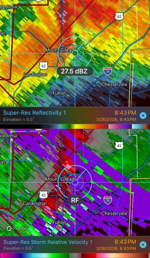
One of the things we talked about in some previous threads is how the RFD is often curling back inward around the tornado, like a cinnamon roll. When you're looking at RFD from the side at a distance, you see the clear slot, but not this spiraling feature. That's usually only visible if you're right under the meso, but occasionally with more LP updrafts you can see it:
View attachment 28901
That means with a HP storm, the the primary mesocyclone and tornado could be behind the RFD precip/gust front in an area that appears to be too far south from where it should be. If the above example was a HP storm, the RFD (clear/blue-ish) areas in that "cinnamon roll" would be full of heavy precip, hiding where the tornado actually would be. That risk is even more pronounced with these huge HP storms/mesos where you really can't visually perceive exactly where the tornado is, only radar can give you the clue (and we've talked about how delayed radar can put you behind the situation easily if you're close to the RFD).
You have to assume the tornado could be virtually anywhere behind the RFD gust front.
One of the coolest visuals of this process I know of is this video from Tornado Raiders:
That's a classic supercell with a relatively small meso, but if it was HP, the very clear RFD in this example would be wall of heavy, opaque precip.