Michael Thompson
EF3
A nice MODIS AQUA picture of storms over southern Iraq and Pakistan on the 29th May.
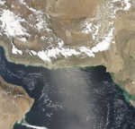
http://rapidfire.sci.gsfc.nasa.gov/subsets/?ArabianSea - for full pictures.
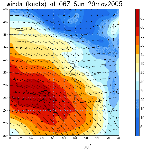
The 1000mb winds show just enough moisture transport from the Gulf / Indian Ocean - the storms still must have been high based as 900 to 750 winds were unimpressive. I actually have a feeling that these storms would look right at home here in Australia in our moisture starved but often unstable spring. Supercells they are NOT.
The 300mb ties in nicely with the sat pic too, with better anvil blowoff towards the jet.
CAPE was around 1000-1500, but over 3000 just offshore. I have a feeling that more moisture got inland then the 06Z analysis shows.
I look at MODIS almost daily and when I see interesting storms will often look at the analysis and there are common threads. Boundaries is probably the biggest, especially outside the tropics - I don't need to tell you guys that I suppose.

Let me know if you like this sort of post and I'll post more occasionally.
http://rapidfire.sci.gsfc.nasa.gov/subsets/?ArabianSea - for full pictures.
The 1000mb winds show just enough moisture transport from the Gulf / Indian Ocean - the storms still must have been high based as 900 to 750 winds were unimpressive. I actually have a feeling that these storms would look right at home here in Australia in our moisture starved but often unstable spring. Supercells they are NOT.
The 300mb ties in nicely with the sat pic too, with better anvil blowoff towards the jet.
CAPE was around 1000-1500, but over 3000 just offshore. I have a feeling that more moisture got inland then the 06Z analysis shows.
I look at MODIS almost daily and when I see interesting storms will often look at the analysis and there are common threads. Boundaries is probably the biggest, especially outside the tropics - I don't need to tell you guys that I suppose.
Let me know if you like this sort of post and I'll post more occasionally.