Dan Robinson
EF5
The current paradigm in meteorology is to assume that all observed funnels are not tornadoes unless there is evidence to the contrary (a visible ground circulation/condensed subvortices/debris cloud or damage after the fact). To my knowledge, there is no evidence or research behind this paradigm, it's just always been an accepted part of severe storms meteorology and storm spotting.
I believe there is enough evidence that this paradigm is false in these specific, but very common, categories of funnels:
A. Laminar funnels under the rotating cloud bases of a supercell mesocyclone. By the time a funnel appears in these scenarios, a damage-capable ground circulation has long since been in progress in some form.
B. Persistent vertical to near-vertical laminar funnels extending more than 1/3 of the way to the ground from updraft bases. These are mostly nonsupercell phenomena associated from the stretching of near-surface vorticity from boundaries in environments with sufficient low-level CAPE. This category would include "cold air funnels" that our current operational paradigm states "rarely reach the surface". In the known cases where a chaser or other observer is directly under such a feature, there has been an observable (damage-capable) ground circulation present.
Proposed research methodology: Assemble a data set of funnel events in the scenarios A and B (outlined above) observed from close range where the ground underneath the funnel is clearly visible, in other words, where the presence or lack of a ground circulation can be conclusively determined. From this data set, calculate the likelihood of a funnel being a tornado (having a damage-capable ground circulation) to either confirm or challenge the current paradigm of assuming most funnels in these scenarios are not tornadoes.
Types of funnels not considered in this research:
Shear funnels: Midlevel vortices or horseshoe vortices.
Transient low-level vortices: Short-lived vortices under updraft bases, advancing gust front shelf clouds or other features.
Criteria: Collected events must meet the following criteria::
1.) A funnel cloud in the category of A or B (described above) is present and extending some discernable distance below cloud base, up to 2/3 of the way to the ground.
2.) The ground underneath of the funnel is clearly visible in at least one of the images/videos, allowing the presence or absence of a ground circulation to be conclusively determined.
Event List: Supercell funnels with ground circulations
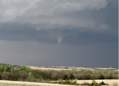
1.) April 29, 2022 - Elmo, Kansas
High-based funnel descended 1/4 of the way to the ground. A damaging circulation was documented at ground level.
Funnel image 1
Funnel Image 2
Ground circulation video 1
2.) December 1, 2018 - Bluffs, Illinois
Supercell tornado funnel descended 1/5 of the way to the ground.
Funnel image 1
Ground circulation image 1
3.) May 16, 2017 - McLean, Texas
Supercell tornado funnel extending 1/4 to 1/2 of the way to ground with continuous visible ground circulation. The funnel eventually fully condensed to ground in the later stages of the tornado.
Funnel/ground circulation image 1
4.) May 10, 2010 - Medford, Oklahoma
Funnel 1/3 of the way to ground with debris cloud appearing after funnel dissipated.
Funnel image 1
Ground circulation image 1
5.) August 24, 2015 - Dubbo, NSW, Australia
Supercell tornado funnel 1/4 way to ground with debris, audible roar and occasional condensed near-ground subvortices.
Tornado and funnel video 1
Event List: Nonsupercell funnels with ground circulations
1.) June 13, 2021 - Tuttle, Oklahoma
"Cold air funnel" descending at least 1/3 of the way to the ground.
Funnel video 1
Ground circulation video 1
2.) May 23, 2021 - Arriba, Colorado
High-based nonsupercell funnel along linear convective base with ground circulation.
Funnel image 1
Funnel video 1
Ground circulation video 1
Could this rise to the level to qualify for a formal published paper? As an outsider to the science community, I'd be interested to hear from qualified individuals if this is possible and the best way to approach it to make it a useful endeavor.
I believe there is enough evidence that this paradigm is false in these specific, but very common, categories of funnels:
A. Laminar funnels under the rotating cloud bases of a supercell mesocyclone. By the time a funnel appears in these scenarios, a damage-capable ground circulation has long since been in progress in some form.
B. Persistent vertical to near-vertical laminar funnels extending more than 1/3 of the way to the ground from updraft bases. These are mostly nonsupercell phenomena associated from the stretching of near-surface vorticity from boundaries in environments with sufficient low-level CAPE. This category would include "cold air funnels" that our current operational paradigm states "rarely reach the surface". In the known cases where a chaser or other observer is directly under such a feature, there has been an observable (damage-capable) ground circulation present.
Proposed research methodology: Assemble a data set of funnel events in the scenarios A and B (outlined above) observed from close range where the ground underneath the funnel is clearly visible, in other words, where the presence or lack of a ground circulation can be conclusively determined. From this data set, calculate the likelihood of a funnel being a tornado (having a damage-capable ground circulation) to either confirm or challenge the current paradigm of assuming most funnels in these scenarios are not tornadoes.
Types of funnels not considered in this research:
Shear funnels: Midlevel vortices or horseshoe vortices.
Transient low-level vortices: Short-lived vortices under updraft bases, advancing gust front shelf clouds or other features.
Criteria: Collected events must meet the following criteria::
1.) A funnel cloud in the category of A or B (described above) is present and extending some discernable distance below cloud base, up to 2/3 of the way to the ground.
2.) The ground underneath of the funnel is clearly visible in at least one of the images/videos, allowing the presence or absence of a ground circulation to be conclusively determined.
Event List: Supercell funnels with ground circulations
1.) April 29, 2022 - Elmo, Kansas
High-based funnel descended 1/4 of the way to the ground. A damaging circulation was documented at ground level.
Funnel image 1
Funnel Image 2
Ground circulation video 1
2.) December 1, 2018 - Bluffs, Illinois
Supercell tornado funnel descended 1/5 of the way to the ground.
Funnel image 1
Ground circulation image 1
3.) May 16, 2017 - McLean, Texas
Supercell tornado funnel extending 1/4 to 1/2 of the way to ground with continuous visible ground circulation. The funnel eventually fully condensed to ground in the later stages of the tornado.
Funnel/ground circulation image 1
4.) May 10, 2010 - Medford, Oklahoma
Funnel 1/3 of the way to ground with debris cloud appearing after funnel dissipated.
Funnel image 1
Ground circulation image 1
5.) August 24, 2015 - Dubbo, NSW, Australia
Supercell tornado funnel 1/4 way to ground with debris, audible roar and occasional condensed near-ground subvortices.
Tornado and funnel video 1
Event List: Nonsupercell funnels with ground circulations
1.) June 13, 2021 - Tuttle, Oklahoma
"Cold air funnel" descending at least 1/3 of the way to the ground.
Funnel video 1
Ground circulation video 1
2.) May 23, 2021 - Arriba, Colorado
High-based nonsupercell funnel along linear convective base with ground circulation.
Funnel image 1
Funnel video 1
Ground circulation video 1
Could this rise to the level to qualify for a formal published paper? As an outsider to the science community, I'd be interested to hear from qualified individuals if this is possible and the best way to approach it to make it a useful endeavor.
Last edited: