Bernard Hulshof
EF0
A relatively low topped (about 10 kms) supercell crossed the Netherlands from southwest to northeast on Monday July 25th. The storm formed near the river Rhine, south of Utrecht and activated over the province of Utrecht. Most likely it died near Meppel, Drenthe.
Over Soest (my hometown) it produced a tornado at about 12.25 LT, which resulted in F0 to possibly F1 damage. My friend and colleague Ben Lankamp did see the tornado and shot several pictures:
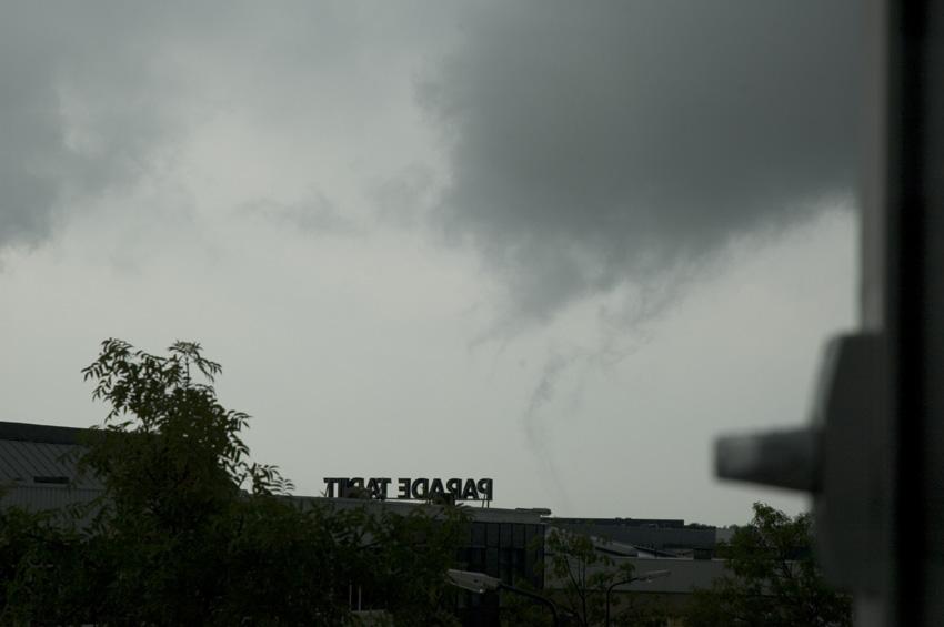
Later that day he performed a damage survey and concluded F0-F1 damage (text in Dutch):
http://www.weerwoord.be/includes/forum_rea...9103&tid=309103
I haven't seen the tornado over Soest, but I chased the storm between 12.40 and 14.40 LT. Fortunately it was rather slow moving, so I could chase in the ideal province of Flevoland. I observed multiple rotating wall clouds, sometimes the rotation could be described as violently. Once in a while rotating fractus clouds could be seen all the way down to surface level. I haven't seen any debris clouds, but I'm rather positive I've seen a tornado. One time while driving I saw multiple funnels rotating around a common centre, making it look like a multiple vortex tornado. De wall clouds occluded after about 15 minutes, but new ones formed almost instantly.
A more detailed chase log (in Dutch): http://www.weerwoord.be/includes/forum_rea...9169&tid=309169
The day after, commercial weather bureau Meteo Consult mentioned a tornado report near Hasselt on their website. This tornado was produced by the same cell I was chasing, but I aborted the chase about 15 minutes too early
Picture of the tornado near Genne/Hasselt, north of Zwolle:
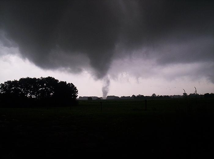
The supercell formed in a very moist and slightly unstable air mass. There was some speed shear present and because of backed surface winds, low level directional shear was present as well. LCL's were extremely low and low level lapse rates were rather steep. Furthermore, no convection formed at the southeast side of the storm, so inflow stayed relatively warm. The cell was rather long-lived, at least 3 hours, produced at least 3 tornadoes and had multiple meso's. So I think it must have been a cyclic supercell.
My chase pictures can be seen on my website (http://www.weatherpictures.nl), but it's hard to photograph rotation!")
Spouts aren't uncommon in The Netherlands. A couple of dozen form each year, mainly over water surfaces. Tornadoes associated with mesocyclones do occur as well, but they aren't that frequent. During the last century there have been several reports of F3-F4 tornadoes though.
Yesterday multiple waterspouts formed in northern parts of the country.
Today and the next few days supercell changes increase again. Estofex has put us under a moderate risk:
http://www.estofex.org/cgi-bin/outlooks.cgi
Bernard
Over Soest (my hometown) it produced a tornado at about 12.25 LT, which resulted in F0 to possibly F1 damage. My friend and colleague Ben Lankamp did see the tornado and shot several pictures:
Later that day he performed a damage survey and concluded F0-F1 damage (text in Dutch):
http://www.weerwoord.be/includes/forum_rea...9103&tid=309103
I haven't seen the tornado over Soest, but I chased the storm between 12.40 and 14.40 LT. Fortunately it was rather slow moving, so I could chase in the ideal province of Flevoland. I observed multiple rotating wall clouds, sometimes the rotation could be described as violently. Once in a while rotating fractus clouds could be seen all the way down to surface level. I haven't seen any debris clouds, but I'm rather positive I've seen a tornado. One time while driving I saw multiple funnels rotating around a common centre, making it look like a multiple vortex tornado. De wall clouds occluded after about 15 minutes, but new ones formed almost instantly.
A more detailed chase log (in Dutch): http://www.weerwoord.be/includes/forum_rea...9169&tid=309169
The day after, commercial weather bureau Meteo Consult mentioned a tornado report near Hasselt on their website. This tornado was produced by the same cell I was chasing, but I aborted the chase about 15 minutes too early
Picture of the tornado near Genne/Hasselt, north of Zwolle:
The supercell formed in a very moist and slightly unstable air mass. There was some speed shear present and because of backed surface winds, low level directional shear was present as well. LCL's were extremely low and low level lapse rates were rather steep. Furthermore, no convection formed at the southeast side of the storm, so inflow stayed relatively warm. The cell was rather long-lived, at least 3 hours, produced at least 3 tornadoes and had multiple meso's. So I think it must have been a cyclic supercell.
My chase pictures can be seen on my website (http://www.weatherpictures.nl), but it's hard to photograph rotation!
Spouts aren't uncommon in The Netherlands. A couple of dozen form each year, mainly over water surfaces. Tornadoes associated with mesocyclones do occur as well, but they aren't that frequent. During the last century there have been several reports of F3-F4 tornadoes though.
Yesterday multiple waterspouts formed in northern parts of the country.
Today and the next few days supercell changes increase again. Estofex has put us under a moderate risk:
http://www.estofex.org/cgi-bin/outlooks.cgi
Bernard
")
