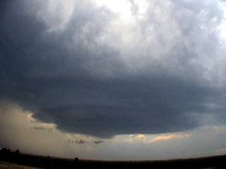
Northside Meso?

Joined
Jan 22, 2006
Messages
49
Location
Stillwater, OK
I guess this could go in the Reports area, but it is more of a question than a report at this time.

This is the second time that I have seen this and I have plenty of questions for most of you who have a much better understanding of meteorological phenomena than myself.

How does a meso and potential tornado form on the north side of a storm? These two experiences fly in the face of conventional chaser/spotter wisdom, from everything that I have learned. The north side of a storm is not receiving the "juice" typically required to sustain tornado development.

The first time I saw this was May 2nd, 2006 just to the west of Hammon, OK. I was observing the storm to my west when this feature became rather evident and produced several small funnels before it (for the lack of a better term) occluded around into the northern side of the storm and disappeared.


I always thought this to be rather odd, and then yesterday I witnessed almost an identical situation. The initial storm development was linear in nature and quite unimpressive from my point of view. But then from the south of Prague, OK I was able to observe this feature as the linear storm seemed to seperate. The bulk of the precipitation had moved off to the northeast, and this secondary "tail-end charlie" seemed to sit and churn in the same area for a little while. This area of defined rotation was enough for someone in the Prague area to sound the tornado sirens, which I could hear to my north. It was wrapping up pretty tight and also produced some funnels, but just couldn't pull the trigger.


But this meso/wall-cloud was on the northern-most edge of the now discrete storm. It then became rain-wrapped and then also occluded into the main body of the storm.


This is then the storm that would go on to produce other wall-clouds/funnels/etc. along I-40, but by then, those features were of a more traditional fashion (i.e., southern, southeastern portion of the supercell with a good source of inflow).

I ask this here because, as a long time lurker and rare poster, I highly respect the knowledge base present on this forum. I have learned so much from this forum for many years now and I value the opinions of the more experienced members of this board. Any help here would be much appreciated.
 
leading edge tornado

I too am no expert and have witnessed the same thing. It is my understanding that a Low Precip Supercell and a Classic Supercell typically have the tornado on the back southwest portion of the storm. A High Precip Supercell has the tornado more on the North leading edge of the storm. I am sure that the storm motion has something to do with it also. May 10th I was chasing storms that moved to the Southeast. Had a little trouble finding the rainfree base on those. Not a good time.
 
The May 2nd, 2006 storm was the northern-most storm on the front of a cold pool that pushed across the state generated by the big boomers in the Texas panhandle. The closest storm to its north was around 90 miles NNW in the Oklahoma panhandle. The Hammon storm then formed a line down towards southern Oklahoma that was more typical of a cold front (undercut ragged bases and linear in nature).

The May 13, 2008 storm had been a part of a NE to SW line of convection that had segmented. I guess, technically speaking, this would have been the right split as the left split continued to move off to the northeast while this storm began its trek eastward at this point. I was just happy to have some good photos and video of the event, as I only saw a couple of other vehicles in my vicinity at the time.

On a side note: It turns out that documenting a storm can be rather tricky when the friendly neighborhood pitbull is trying to jump in your vehicle through the open window. After about the 12th CG within a mile, and some gentle encouragement from myself, he finally scurried back home.
 
I had something similar to this last season in my home county, I reported the rotation, and funnel, and started getting phone calls from people on the south of the storm saying that they couldn't see anything, has started some problems between myself and some other people who concider them selfs chasers and are not.
 
It would be a lot easier if we had some radar grabs but here are two possible answers I can think of:

1) If it was more linear than supercellular and it was bowing out in the center the circulation you saw could have been a result of this (taken from John Davies blog). It is also possible, but probably not likely, that you saw what is called a 'comma-head' circulation, which would be in the top of the line in the fourth illustration:

mesovortices-tors-schematic-revised.gif


2) If it was supercellular, the circulation to the north could have been the 'main' meso and the the rotation you saw to the south could have been on the flanking line with the RFD blowing down what could have looked like a wall cloud with some finger funnels. I was watching Chris Rice's stream a couple nights ago and it looked like they had a few of these. This picture was taken on May 5th last year just north of Great Bend, KS. In the foreground is a wall cloud on the flanking line which we mistook as the main circulation. It wasn't until post-processing and contrast enhancing that we realized we could have been looking at a large tornado back in there (jury is still out on this one):

CLCimages1002.jpg
 
The northside meso is probably just the older meso being shed off the back of the storm. You can see this pretty clearly on the radar sometimes...a circulation on the NW flank of a supercell with another circulation where it should be on the right rear flank. Since it is the remains of the storm, it's not surprising that it produces funnels. In fact, these older mesos can produce tornadoes...May 29 2004 in SW of Harper KS and May 4 2007 W of Arnette OK...both of those tornadoes were produced from mesos that were no longer the main player and were being shed off (storm-wise....tornado-wise obviously they were). Oh, April 23, 2007, W of Protection, KS...one didn't produce until real late. I am assuming the reason these can end up looking/being so interesting is the occlusion process of the meso. Of course, there is what was mentioned above which is left splits...but that's easier to understand.
 
Last edited by a moderator:
That diagram of the meso vorticies is very interesting, I havent seen it present that way as far as tornadic evolution.

Matt Fischer and I have been pondering over the events of our most recent chase [5-10-08] down near Clarksdale, MS and this has shed some new light.

A "line" of storms seemed to form on the rear flank and former hook region of the massive supercell that tracked SEward from central AR into NWern MS. Like the other examples this area produced several suggestive lowerings in a non-typical region of the storm, one pictured here in this video still:
5101sn4.jpg


We could note the rotation on radar but it just didnt look "traditional" at the time. We ended up noting a series of powerflashes under a somewhat ragged lowering [pictured here]
51042ua7.jpg


At the time we had discussed the possibility of a mesovorticy [which is still a new term by standard and up till now the best example we've seen was 8-23-07 here in chicago]

The storm was already tornado warned since AR so we reported this as a possible tornado. Looking at the survey from the NWS in memphis they went with a long area of intense straight line wind damage [110mph!] as well as a few brief EF-1 touch downs. After seeing the above graphic Chad posted this seems to fit the event almost perfect and would also fit the characteristics of a mesovorticy as having an enhanced area of damaging winds, but the diagram illustrating how a tornado may form is a 1st for me, but makes total sense.

So Jeff I would say if your storm took on a more linear appearance, then based off my experience noted above I would think the mesovorticy is a good possibility....but Im no expert, just trying to offer a similar experience/situation to analyze.
 
I can't seem to find a radar grab from Tuesday, but I did find one from
May 2, 2006 around 6:33 p.m. to give you an idea what type of storm I was looking at. The storm in question is the larger reflectivity return in exact west-central Oklahoma. It appears to be more of a broken line of embedded supercells as opposed to a bowed line segment, although I see qualities of both on this radar grab.
May22006RadarGrab1.gif
[/IMG]

The storm on Tuesday did in fact take on an appearance similar to that in the photo that Chad posted. This was almost an hour later near Checotah when the storm was really trying to put something on the ground. The flanking line bows up into the meso from the SW, providing good inflow and having the more traditional look, structure, and behavior of a classic supercell.
May13200817Resized.jpg
[/IMG]

The original northern meso that I observed seemed to be making a much more concerted effort to produce for being on the "wrong" side of the storm.

Again, I really appreciate the opinions and suggestions provided by the other members. This helps me quite a bit and increases my understanding of storm behavior and evolution.
 
Jeff,

Interesting picture and question. Regarding the May 2 2006 case, I would guess that what was happening was a transition from a supercell type of storm to more of a bow echo type of storm.

There are several reasons I think this is the case. Your first picture looks more like the initial stages of a shelf cloud. Maybe morphing from the mesocyclone. Notice how the base of the clouds look like they are pointing away from the rain. It's vague I know but that's what it looks like. I have also seen numerous times where funnels form on this leading edge. Second, I downloaded some radar data and at approx 2330Z (roughly the time you indicated this picture was taken) the radar looked like this...
y1pd0KPHMhkKFfAcnzVr-pl3zOOCAGQyX6gk9u8dHJSSAln5-vRX05bBCf0XBRTTRBrz8D6-zzCqaY


15 minutes later it seemed like a well defined bow...
y1pd0KPHMhkKFd-jPLFbVFB7oZZKyRYpKtHgewQhyllfvOTurV3sSo7wTq9vfV-31cO5ysUmIOzHD0


This idea seems to be supported by a LSR out of Hammon of an 85 mph wind gust at 2326
[SIZE=-1]2326[/SIZE][SIZE=-1] 85[/SIZE][SIZE=-1] HAMMON [/SIZE][SIZE=-1]ROGER MILLS [/SIZE][SIZE=-1]OK[/SIZE][SIZE=-1]3563[/SIZE][SIZE=-1] 9938[/SIZE][SIZE=-2] NEAR INTERSECTION OF HWY 33 AND 34 (OUN)[/SIZE]
Of course this is just my humble opinion.
 
Apologies if this is a dumb question, but was it a left split storm? If so, the meso could have been on the N side (anticyclonic).

i was just about to ask the same thing...

im not expert on storm mechanics by any means, but it was my understanding that anti-cyclonic tornadoes/wall clouds form on the northern end, as opposed to the southern end...

maybe the outflow had pushed the storm forward really fast and kind of forced some kind of rotation on that end?

just something to think about...if it was just there for a minute, i guess that there could have been enough energy and forcing from the outflow to cause the storm to get that rotation in it...but like i said, im really not qualified to say for sure...
 
Good day all,

Below is a picture of a northern, and clearly anti-cyclonic meso near Altus, OK on May 26, 2004. It looks like a supercell you would see in Australia, a mirror image (precip is to the left, not the right)! The view is to the West.

m5ameso.jpg


Description from chase log: This is an LP supercell that formed the left-split of a thunderstorm complex. The view is to the west, and we can see several strange differences from a "normal" supercell. Note the precipitation is to the left (not the right). The vault region is also to the left. The inflow is coming in from the right (not the left as usually found in supercells). It is quite possible that this was an ANTI-MESOCYCLONE, or a CLOCKWISE rotating updraft. The storm did not last long, and raced to the NE at nearly 50 MPH. Note the "stacked plate" effect.
 
Back
Top