Mike Smith said:
Pardon me re-posting some color information that I have posted before. I've studied colors and their meaning quite a bit (still have the textbook) and I have suggested the following, without success, to the NWS.
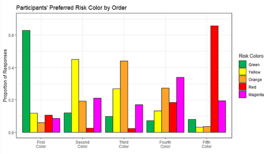
Here is my proposed color scheme for SPC's outlooks:
- Warm gray - general thunderstorms
- Yellow - significant risk of severe (I'm changing the names of the categories)
- Orange - enhanced risk of severe
- Hot purple - high risk of severe
- Red - extreme risk of severe (rare)
( ... )
Not trying to knock down your ideas or anything, but just some "my thoughts"
Personally I see magenta as a 'stronger' color so if it were me, I'd flip the last 2 (plus it keeps the colors in a more "natural" order) based on how a computer would sort them, or by spectrum)
(for me, "proper" order for colors on anything is based on how a computer would sort them, or by spectrum so: red,yellow,green,cyan,blue,magenta/purple .. It bugs me seeing colors out of natural/computer order (maybe thats a little ocd-ish thing .lol. ) but they look fine in reverse order too & magenta after red)
One thing specifically about SPC, and in this case the names for outlook categories: Particuraly in the past year, more & more I'm seeing and hearing simply "level 1 of 5, 2 of 5, etc" (and not marginal/slight/etc) ... and not just freom random internet & YouTube guys, but on professional stuff like TV news weather, even seen it in the local NWS's area forecast descussion. I don't know if thats something per SPC/NWS guidence, or just one of those things that started on the net & is gaining hold everywhere, but personally I like the general idea / prefer numbers over names for weather stuff anyway.
I don't know about getting rid of 'severe thunderstorm warning', but certainly could see sort of 'hail warning' (maybe combined with the )
And "damaging wind warning" by itself (specifically related to thunderstorms) would IMO get too mixed up with "high wind warning" (something we get here where I am - more likely in winter) where its just wind and there is no "storm" for say - sky can be totally clear! Generally if there is any clouds for these type of events its a mountain-wave cloud.
Maybe instead of "severe thunderstorm" it could be "thunderstorm wind (and/or hail) warning" .. that very specifically keeps it separate from "high wind warning".
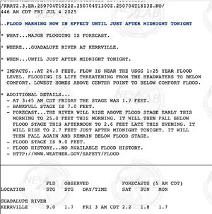
'Flash flood warning' seems ok being as-is, I think most people get the idea of what it is/means.
I'm curious on how would 'river flood warning' be different? Would that be specifically for the slower-moving/longer term floods along rivers - where it may last for days instead of hours? What about streams or creeks? Would they still label it as a 'river flood warning'?