• While Stormtrack has discontinued its hosting of SpotterNetwork support on the forums, keep in mind that support for SpotterNetwork issues is available by emailing [email protected].

Legislation to Create a National Disaster Review Board

The two Texas NWS offices most closely involved in forecasting and warning about the flooding on the Guadalupe River — Austin-San Antonio and San Angelo...

, and I'm really unsure if phone notifications go out when they are issued.
Behind on this thread, but what to point out a couple of things.

The article that Sean posted, like several others I have seen in the media, incorrectly report that the 1 death in Tom Green County (San Angelo) was some how related to the Guadalupe River. It wasn't (Mike already noted this). Almost all of the San Angelo (SJT) WFO area is in the Colorado River Basin. The southeast edge of the SJT WFO is Mason and Kimble (Junction) Counties which are still northwest of the Guadalupe River basin. The northern part of the SJT CWA is in the Brazos River basin. A good map of this is USGS | InFRM - Watershed Hydrology Assessment Viewer

The San Angelo flooding was actually "East Ditch" or "East Draw" according to local media. This runs into the North Concho River, that runs into the Concho River, which meets up with the Colorado River at O.H. Ivie Lake.

One of the most surprising facts about this Guadalupe River flooding event is that the Guadalupe River Basin begins in Kerr County. This was not a wall of water that came all the way from San Angelo like some media reports would lead you to believe - it was a lot of rain that fell very quickly in a very small area with a limestone base right under the surface and lots of hills. The northern part of Kerr County is even in the Colorado River basin. When you look at a aerial photo of this area when it is not in a flood you can see that the Guadalupe has almost no water in Kerr County normally and has to be have dams just to make swimming holes for the camps.

On the subject of WEA notifications, they go out for Flash Flood Warnings tagged "considerable” or “catastrophic” (which many of the EWX ones on 7/4 where). Source: https://www.noaa.gov/media-release/flash-flood-warnings-now-issued-in-easy-to-read-format

I'm really hoping a disaster review board happens. There has been a lot of finger pointing - first at NWS, then at local officials. I fell like this is missing the point. It does appear that the local government didn't do any where close to what they should have, but when you keep asking "Why, Why, Why" the root cause of this disaster is camp operators choose to house kids in a regulatory floodway and flood plain and other people choose to camp in the flood plain during a Flash Flood Watch. A national disaster review board would likely help get to the bottom of these disasters and hopefully root causes would then get addressed.
 
On the subject of WEA notifications, they go out for Flash Flood Warnings tagged "considerable” or “catastrophic” (which many of the EWX ones on 7/4 where).

Thanks for the note, Randy.

The flash flood warnings I've received via WEA have been much more truncated than what is shown at your link. Do you have screen captures or the exact text (formatted or unformatted) for the Kerr Co. FFW and FFE on the 4th?

After the study of the NWS's mess of a tornado warning program, a NDRB is our only hope of fixing this. Thanks for your support!!
 
Do you have screen captures or the exact text (formatted or unformatted) for the Kerr Co. FFW and FFE on the 4th?
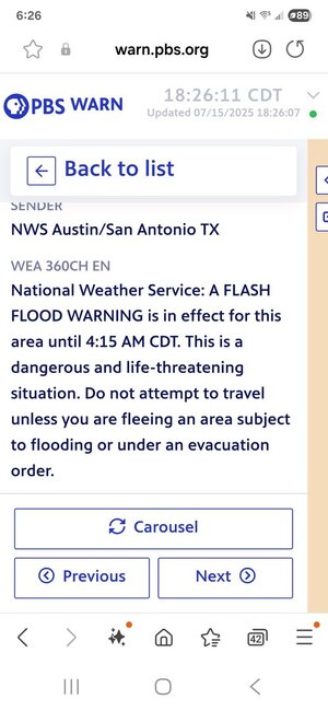
I don't, but you can get it at PBS - WARN . Hit the >> then the 3 vertical bars with squares on them and adjust the filter. Make sure you set it to expired. Most modern cell phones would display the 360 character text only. Older phones might still use the 90 character text. The instructions would not appear. Here is a screen shot of the first one that went out as a WEA at 1:14 am.Screenshot_20250715_182612_Samsung Internet.jpg
 
Thanks, Randy. Some time quite a bit back in this thread there were questions about whether the initial warning at 1:14 included the wording "life threatening". This indicates that it did. I do think that having summer camps and campgrounds near the river in such a flood-prone area is a big part of the problem. A big reason why we need a NDRB. On a related matter, I have been unable to understand why there were still campers earlier this month (but after the TX floods) along the Rio Ruidoso in NM when the flood happened that took 3 lives. There had been flash floods there the previous two days before the deadly one. Why anyone was still there, or why those campgrounds were still even open, is beyond me.
 
Saw an interesting thread on social media. They showed a radar shot that had red polygons for tornado warnings, yellow for severe thunderstorms, and green for flash floods. If you are looking at the map and see red, yellow, and green warnings which are you most likely to ignore?
 
Matt Zumbrunn said:
Saw an interesting thread on social media. They showed a radar shot that had red polygons for tornado warnings, yellow for severe thunderstorms, and green for flash floods. If you are looking at the map and see red, yellow, and green warnings which are you most likely to ignore?
Those are the colors I do see for the various warnings (plus beige for 'special weather statement' & a purple-ish color for 'snow-squall warning') ...

As far as which I might ignore, it would depend on where I was at the time.
At home, I could end up getting any of them, though beige/'special weather statement' & yellow/'severe thunderstorm warning' are the most common.
And those are the 2 I'd be most likely to pay attention to - especially the yellow! (because it could mean large hail)
red/tornado I'd certainly pay attention to (basically as a heightened version of yellow/severe, the actual chance of a tornado here is slim-to-none)

And in reality, if there's a severe storm headed this way, I might (in spring) be trying to do some garden protection & making sure car is in garage... and then if its not raining & there's good lightning show, simple fact is I'm gonna be on the deck or roof watching/videoing it til the rain hits. .lol. I won't be hiding in the basement thats forsure. .lol.
Green/flash flood I can safely ignore.

Now its different if I'm out driving around...
Things are gonna be different. I would want to avoid actually being in a yellow or red (avoiding the hail part or really heavy rain to), but bight want to be close enough to see some action - like lightning or tornado.
And green, yeah that would be something I'd want to be very cautious about & probably just avoid the area if I could. (same goes for purple/snow-squall... I'd rather not drive in that at all)

In the mountains - particularly in a canyon or similar, the green would be very important, I'd want to get away from that situation asap. (same goes for being near a creek or river), and its really related, but I'd want away if it was severe-warned too since that could easily mean heavy rain. (oh and if there was even a chance of snow, forget even going to the mountains in the 1st place. .lol.)
 
Pardon me re-posting some color information that I have posted before. I've studied colors and their meaning quite a bit (still have the textbook) and I have suggested the following, without success, to the NWS.

Here is my proposed color scheme for SPC's outlooks:
  • Warm gray - general thunderstorms
  • Yellow - significant risk of severe (I'm changing the names of the categories)
  • Orange - enhanced risk of severe
  • Hot purple - high risk of severe
  • Red - extreme risk of severe (rare)
Note: it is possible to put the above in a gray scale that would allow colorblind people to derive the information from the map.

Five categories is slicing the bread too thin. As far as I can tell, SPC's outlooks have not improved since the 5 category outlooks. [That is unofficial.]
  • Tornado warnings = red.
  • Confirmed tornadoes = flashing red
[No more categories of tornado warnings; TOR-E's verify at a rotten 17%. Really!]

The term "severe thunderstorm warning" would be retired. No one in the general public knows what it means. Replacing SVR will be:
  • "Hail Warning for 2" Diameter Hailstones"
  • Damaging Wind Warnings for 60-79 mph winds.
  • Extreme Wind Warning for 80+ mph winds. [Higher forecast wind speeds can be stated]
We go back to one flash flood and one river flood warning format.
  • Flash Warning = turquoise In the text of the warning, the extent of the warning would be stated.
  • River Flood Warning = a turquoise tint along the river.
 
Mike Smith said:
Pardon me re-posting some color information that I have posted before. I've studied colors and their meaning quite a bit (still have the textbook) and I have suggested the following, without success, to the NWS.

Here is my proposed color scheme for SPC's outlooks:
  • Warm gray - general thunderstorms
  • Yellow - significant risk of severe (I'm changing the names of the categories)
  • Orange - enhanced risk of severe
  • Hot purple - high risk of severe
  • Red - extreme risk of severe (rare)
( ... )
Not trying to knock down your ideas or anything, but just some "my thoughts"

Personally I see magenta as a 'stronger' color so if it were me, I'd flip the last 2 (plus it keeps the colors in a more "natural" order) based on how a computer would sort them, or by spectrum)
(for me, "proper" order for colors on anything is based on how a computer would sort them, or by spectrum so: red,yellow,green,cyan,blue,magenta/purple .. It bugs me seeing colors out of natural/computer order (maybe thats a little ocd-ish thing .lol. ) but they look fine in reverse order too & magenta after red)

One thing specifically about SPC, and in this case the names for outlook categories: Particuraly in the past year, more & more I'm seeing and hearing simply "level 1 of 5, 2 of 5, etc" (and not marginal/slight/etc) ... and not just freom random internet & YouTube guys, but on professional stuff like TV news weather, even seen it in the local NWS's area forecast descussion. I don't know if thats something per SPC/NWS guidence, or just one of those things that started on the net & is gaining hold everywhere, but personally I like the general idea / prefer numbers over names for weather stuff anyway.

I don't know about getting rid of 'severe thunderstorm warning', but certainly could see sort of 'hail warning' (maybe combined with the )
And "damaging wind warning" by itself (specifically related to thunderstorms) would IMO get too mixed up with "high wind warning" (something we get here where I am - more likely in winter) where its just wind and there is no "storm" for say - sky can be totally clear! Generally if there is any clouds for these type of events its a mountain-wave cloud.

Maybe instead of "severe thunderstorm" it could be "thunderstorm wind (and/or hail) warning" .. that very specifically keeps it separate from "high wind warning".

'Flash flood warning' seems ok being as-is, I think most people get the idea of what it is/means.
I'm curious on how would 'river flood warning' be different? Would that be specifically for the slower-moving/longer term floods along rivers - where it may last for days instead of hours? What about streams or creeks? Would they still label it as a 'river flood warning'?
 
Personally I see magenta as a 'stronger' color so if it were me, I'd flip the last 2 (plus it keeps the colors in a more "natural" order) based on how a computer would sort them, or by spectrum)

Hi James, thanks for your well-considered thoughts.

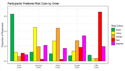
I based the ranking on the studies of color perceptions as done for use on television (textbook I mentioned). It also turns out that SPC's Convective Outlook Colors have been studied. The general public wants red for the worst condition. See nearby graph. The study itself is here: Colorful Language: Investigating Public Interpretation of the Storm Prediction Center Convective Outlook

Please keep in mind that we are weather scientists and/or weather aficionados. Studies have shown that 80% of the public views adverse weather as a major annoyance and they want to spend as little time as possible thinking about it. Thus, more intuitive is better.

For me, the #1 thing is getting green, a "safe" color out of the general thunderstorm and "marginal" categories. Green sends completely the wrong message for convective hazards.

The problem with the numbers for the SPC hazards, as interpreted by the public: is #1 or #5 worst? In the military, DEFCOM 1 is worst. At SPC #5 is worst.

Green is fine in flood categories as green is associated with abundant rain (rain forests, etc.).

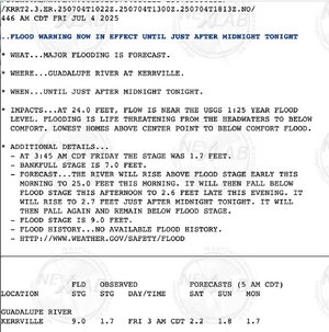
I have attached a river flood warning (NWS calls these "riverine" warnings) from Texas the morning of July 4. TV meteorologists are now converting these into graphic displays, thus the colors mentioned.

With regard to severe thunderstorm warnings, go out and find a couple friends who have nothing to do with meteorology. Ask them the definitions of "severe." I'll wager neither can say, "one inch hail and/or 58 mph winds" or worse. If we want our warnings to be effective, we have to design them so they can be understood without any scientific or specialty training whatsoever.

Again, thank you for your thoughts.
 

Attachments

  • Screenshot 2025-08-19 at 11.53.46 AM.png
    Screenshot 2025-08-19 at 11.53.46 AM.png
    444.6 KB · Views: 1
  • Screenshot 2025-08-19 at 12.00.49 PM.png
    Screenshot 2025-08-19 at 12.00.49 PM.png
    632.6 KB · Views: 1
Following the disastrous tornado in St. Louis on May 16, the city hired an independent consultant to review what went wrong. According to the St. Louis Post-Dispatch, the following were some of the things the consultant concluded:

"The city's emergency management staffers were at an off-site workshop and away from the agency's siren equipment when the tornado hit, despite early storm warnings. Communication then broke down between the emergency management chief and a fire dispatcher who could have triggered the sirens. Even if the dispatcher had triggered the sirens, nothing would have changed because the button that activates the sirens wasn't working. And even if it had been working, some sirens in the path of the tornado wouldn't have gone off because they were broken."

The report includes a detailed analysis of things that went wrong and recommendations on how to prevent future failures of this nature. It strikes me as similar in nature to what an NDRB would do, but having the latter would ensure that something like this would be done with any major disaster. You can read the report at this link:


I have not yet read the entire report, but what I have read seems thorough and convincing. Some of the difficulties were associated with problems associated with a transition from an old warning system to a newer one. Certainly there is also a lesson there for any entity trying to update its warning infrastructure.
 
Hi James, thanks for your well-considered thoughts.


The problem with the numbers for the SPC hazards, as interpreted by the public: is #1 or #5 worst? In the military, DEFCOM 1 is worst. At SPC #5 is worst.
What I have heard more often in the past year or so is something along the lines of "level 3 our of 5," etc. I think when you have the "out of five" wording most people would understand that five is the highest, and that you ought to worry a lot more about "4 out of 5" than "1 out of 5." I have always found the verbiage confusing - to me "enhanced" sounds like more than "moderate." But with the numbers, you get a clearer sense of the level of risk compared to the highest. "5 out of 5" would, I think, tell most people that you had better be alert.
 
I have always found the verbiage confusing - to me "enhanced" sounds like more than "moderate.

Please note that my proposal eliminates "moderate."

People have no idea whether slight is worse or better than "enhanced" nor do they understand whether enhanced is better or worse than moderate.

According to the paper, cited above, SPC has been working on changes for seven years which is one of the serious issues with NWS culture.
 
Back
Top