Legislation to Create a National Disaster Review Board

--> I haven't read the bill, so I will ask you. What qualifies as a disaster in the Bill? only terrestrial? or are space impacts a consideration in it as well.

All natural disasters as I recall. There is no differentiation between earth and space. However, I've said several times the bill needs tweaking. In the middle of 80 some pages of verbiage about natural disasters, someone stuck in "school shootings." I have no problem with a study of school shootings but that requires completely different expertise than natural disasters. It needs to be removed from the bill.
 
I'm not sure what point you are making. The whole point of tornado warnings is to give people advance notice that a tornado is going to occur in their area. At the time of a forming or in-progress tornado, you do not know how long it is going to last.

Livonia occurred in a densely populated area. One person died and a family's life was turned upside down. Could a quality warning have saved her? We don't know. But we do know this: The NWS never issued a tornado warning on that tornado.
The point is that QLCS spin-up type tornadoes (like Livonia) tend to be hard to warn due to their brief nature.
 
The point is that QLCS spin-up type tornadoes (like Livonia) tend to be hard to warn due to their brief nature.
I think it is possible to assess and warn of conditions favorable for QLCS tornado formation in advance of the actual mesovortex formation. The Tulsa WSO has issued such advisories in the past, but I don't recall the lead time. Perhaps 20-30 minutes sticks in my mind. Not for the actual tornado formation, of course--just advising that conditions were favorable for QLCS tornado formation and that QLCS tornados can spin up and dissipate quickly with little time for warning.

I think the bigger issue here is that there was not even a severe thunderstorm warning for the storm that hit Livonia, so people weren't even thinking "severe thunderstorm wind damage". Maybe someone has written up a case study on the event and has assessed whether or not a severe thunderstorm warning should have been issued. That would be an interesting read
 
The point is that QLCS spin-up type tornadoes (like Livonia) tend to be hard to warn due to their brief nature.

Maybe so. So maybe that’s the conclusion of the study of the event - i.e., it was a QLCS tornado, the science isn’t there yet to provide warnings for those, nobody did anything wrong, etc. But enough studies like that help keep the pressure on to advance the science to that point. Or to find other ways to deal with the scenario, such as Geoff’s idea above.
 
I think it is possible to assess and warn of conditions favorable for QLCS tornado formation in advance of the actual mesovortex formation. The Tulsa WSO has issued such advisories in the past, but I don't recall the lead time. Perhaps 20-30 minutes sticks in my mind. Not for the actual tornado formation, of course--just advising that conditions were favorable for QLCS tornado formation and that QLCS tornados can spin up and dissipate quickly with little time for warning.

I think the bigger issue here is that there was not even a severe thunderstorm warning for the storm that hit Livonia, so people weren't even thinking "severe thunderstorm wind damage". Maybe someone has written up a case study on the event and has assessed whether or not a severe thunderstorm warning should have been issued. That would be an interesting read
Livonia, MI EF1 tornado is quite interesting to say the least
 
Here's where I disagree w/r/t to Livonia. The goal of WEA is to be able to provide instant warning of storms instead of the lag that used to exist with sending them out on the teletype, the TV met telling master control she/he had to air a tornado warning and then airing it.

Livonia was not a 100 yard path. See: Whitman Unwarned Tornado, Part Two; Livonia Fatal Unwarned Tornado Reports for a map. I'm not a fan of WEA because of its many deficiencies. But, if we we are going claim we can do these instant warnings, then we should do them.

Mike, it's possible any kind of damaging wind warning might have prevented the death in the Livonia storm, since it was caused by a tree falling on a house while a 2-year old and his mother were sleeping. I just don't know if any kind of damaging wind warning was issued for the Livonia area; I can find no evidence for one. The proposed National Disaster Review Board would certainly assess that as part of the process.

As far as a case study--given that there are methods that can be used to assess whether or not QLCS mesocyclone development can be anticipated with a 30+ minute lead time, it would be interesting to see someone apply those techniques to the Livonia storm to determine whether or not a QLCS tornado could have been anticipated. (I'm assuming they were not, but have no way to know for sure.)

The analysis in your post (see above) is more thorough than what the Detroit WSFO office has presented. However, much more can be done--an analysis of both the lack of a damaging wind warning and any warning of the potential for QLCS tornado development is yet to be presented.
 
Last edited:
Now that we have more info on the terrible loss of life in the Carolinas (~250) and the report from the investors into the Maui Wildfire, we need National Disaster Review Board more than ever!

Boiling it down, some of the mistakes made in the Boulder Fire (19 months before) were also made in the Maui Fire. A power line fell in both cities that caused a small fire. Both were extinguished (so the respective fire departments thought) so the firemen left. Both fires re-flared.. In addition, there were problems with evacuations. In the cause of Maui's, the NWS issued an extremely strongly worded wildfire forecast four days before that called for gusts to 90 mph. The investigators (from the Hawaii AG's office) found no one (fire, police, EM's, hospitals) did anything with that forecast. All four Maui EM's went to Honolulu for routine meetings and were not on the island for the fires!

North Carolina: We now know that there was sufficient info was available to order pro-active evacuations could have been issued. This may have mitigated the death toll.

If you are an aircraft designer, for example, you go to the NTSB's web page if you want to know about icing threats, you just go to their database to look up icing accidents and incidents. There is nothing like that in the field of disasters. When I was in my 20's, we had a major commercial airliner crash about every year, sometimes more than one per year. The last fatality involved by a scheduled airline flight was a single person killed when an Southwest Airline engine exploded in 2018. The last "crash" was in Buffalo in 2009 when 50 people perished due to icing. This is an incredible level of safety, primarily brought about by the work of the NTSB.

I talk about this on Sharyl Attkisson's podcast, just out: Appearance on Sharyl Attkisson's Podcast Many of you will recognize her from her Sunday morning news program, Full Measure.

I don't advise doing anything between now and the election, but after, and if you agree, please contact your congresspeople to see if they would consider moving the bills before Congress pertaining to the NDRB.

Post Script: I forgot to add the info from the nearby tweet. A Wall Street Journal investigation and an independent investigation showed that FEMA's flood risk maps were badly inaccurate. Please see: FEMA's Map Underestimated North Carolina Flood Risk , plus more has come to light since that posting. It turns out that many of the homes should have had flood insurance but could not get it because -- per FEMA's maps -- they were not at 100 yr or higher flood risk. Think how much of the financial devastation could have been mitigated with a NDRB possibly discovering this in an earlier investigation and helping FEMA fix the problem.
 

Attachments

  • Screenshot 2024-10-28 at 5.02.48 PM.png
    Screenshot 2024-10-28 at 5.02.48 PM.png
    162.4 KB · Views: 4
Last edited:
It turns out that many of the homes should have had flood insurance but could not get it because -- per FEMA's maps -- they were not at 100 yr or higher flood risk.
This is a popular myth, but it is incorrect. Anyone can buy flood insurance regardless of their flood risk zone as long as they live in a community that participates in the National Flood Insurance Program (NFIP).

The NFIP enables property owners to purchase flood insurance. In return, communities agree to adopt and implement local floodplain management regulations that contribute to protecting lives and reducing the risk of new construction and substantial improvements from future flooding. You can find out what communities are and are not participants at https://www.fema.gov/flood-insurance/work-with-nfip/community-status-book.

In North Carolina, 594 communities participate in NFIP, only 27 do not.
 
This is a popular myth, but it is incorrect. Anyone can buy flood insurance regardless of their flood risk zone as long as they live in a community that participates in the National Flood Insurance Program (NFIP).

The NFIP enables property owners to purchase flood insurance. In return, communities agree to adopt and implement local floodplain management regulations that contribute to protecting lives and reducing the risk of new construction and substantial improvements from future flooding. You can find out what communities are and are not participants at Community Status Book.

In North Carolina, 594 communities participate in NFIP, only 27 do not.

Randy, thank you but I made two attempts to purchase flood insurance and was told it was not available in the location of the home in question. I thought I would buy it for a year until I got a better "feel" for the meteorology/topography of the location and then either continue or drop it.

Is it possible that neither the realtor nor the broker knew what they were talking about? Yes, it is but I don't think so as they both had years of experience working in the area in question. I suppose it is possible the community was not taking the proper mitigation measures.

In a private sector flood insurance paradigm, the insurance companies would have to cover entire states independent of what a community might do.
 
Another major forecast and warning bust: this time in central Oklahoma.
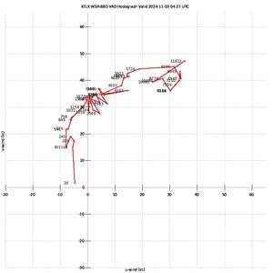
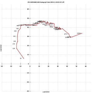
Have a lot to say about this. I went to the Creed/3 Doors Down concert last night at paycom center and got back to Norman around 11. Stopped off at Waffle House for dinner and then sat down at my computer. It became pretty obvious a brief tornado had happened near Wanette/Tribbey in Pottawatomie County. This was right around 11:30. NWS put a tornado possible tag on that storm in the severe warning. The signature from KTLX was pretty decent. I grabbed a snap of the VWP at that time. Somewhat impressive.

Messenger_creation_8B26E738-19C8-41CD-A9D8-85FF74024763.jpg

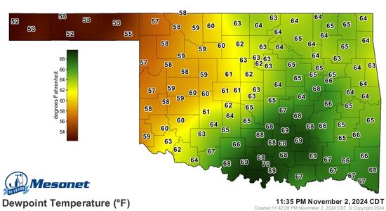
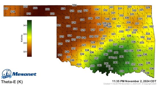
It became obvious that we had a decent environment for tornadoes, with the nose of the 300mb jet coming into south central Oklahoma. A nice pool of moisture/theta-e tongue sat right across Central Oklahoma and storms were showing good updrafts & lightning on radar. They were mostly going along the WF from southwest to northeast.

Dewpoints.jpgThetaE.jpg
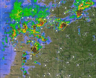
As you can see, some decent lightning. The bolt icons are from ENTLN lightning network. The + signs are from the GOES Lightning Mapper on the satellite. We had numerous healthy updrafts with theta e rich air blasting into the OKC metro

Radar 2345 KTLX.jpg

SPC issued a severe thunderstorm watch at 1150 with a 20/2 probability of tornadoes/strong tornadoes. It seemed they were already underplaying it at this point with the parameters in place. Would love to find out the rationale on the SVR vs TOR then.

I refreshed the TLX VAD hodo again about 12:30 am. It had significantly changed as the warm front crossed by the radar site. It was obvious to me at this point we had a very significant tornado environment on our hands.

Messenger_creation_4A8DB2C2-CE06-4A45-B009-0F01447065F7.jpg

Messenger_creation_81F00059-E3C0-4EA7-B141-0DEADBCCAB69.jpg

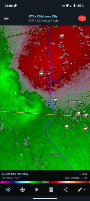
A little after 1 am we had the storm go over Norman. I noticed the convergence really showing up on the TDWR radar about 1:20am and also saw Andrew Berrington mention it on twitter. They issued the tornado warning at 1:21am it appears.


It took SPC until 1:40 am to change the watch to a tornado watch.

My question really comes down to resource management. Does the NWS have any sort of contingency plan in place to have other offices pick up the slack? Fort Worth or Amarillo or Lubbock could have just as easily issued on the storms in southwest Oklahoma at that time to allow the people in Norman to focus on OKC area. Was there any thought from the forecasters in SPC noticing and knocking on the window like "Hey, yall need help?". Does that even happen?

If this was one failure, we could just say "bad night, sorry bro" but these seem to keep happening. How does our government keep getting worse over the years? (rhetorical...)

When a fat uneducated moron as myself can sit comfortably in my living room after a Creed concert and recognize what is going on, it seems like people who are paid to do this professionally should have noticed.

Mike feel free to take anything from this post for your blog post. A long-term archive online is a good thing in my opinion.
 
My question really comes down to resource management. Does the NWS have any sort of contingency plan in place to have other offices pick up the slack? Fort Worth or Amarillo or Lubbock could have just as easily issued on the storms in southwest Oklahoma at that time to allow the people in Norman to focus on OKC area. Was there any thought from the forecasters in SPC noticing and knocking on the window like "Hey, yall need help?". Does that even happen?

Yes, it does. TUL is supposed to be the relief office for OUN. However, it is generally used for outages, I think, rather than NWS relief. There are some in the NWS that want to change that.

What is so astonishing is the obvious deterioration in tornado watches. While the NWS, so far, has refused to release its SPC verification figures, it is clearly obvious. There's no doubt that should have been a tornado watch last night.

As to the awful warnings, it doesn't have to be this way. I know at least one private sector wx company was on top of it. I'm trying to get details and will add them to my blog piece when I have them.

The NWS is in serious trouble. NWS is starving for resources and no one at NOAA HQ cares. The rejection of Barry Myers at NOAA administrator is one of the stupidest things our Senate has done in the last 20 years (which is saying something)!! We need to move the NWS out of NOAA and into an independent agency. I suspect much more needs to be done but we need a NDRB -- desperately.

If you agree, write your congresspeople but wait until at least a week after the election.
 
If this was one failure, we could just say "bad night, sorry bro" but these seem to keep happening.
I've long thought a classical education in math & physics doesn't suddenly turn someone into a competent weather forecaster.
We need improved training & mentorship once hired. Additionally, over-reliance on computer models can erode skill in actual prediction.
As an aside, OKC's Mike Morgan impressed me as an example of a meteorologist who didn't live and predict only by the computer output.
 
Back
Top