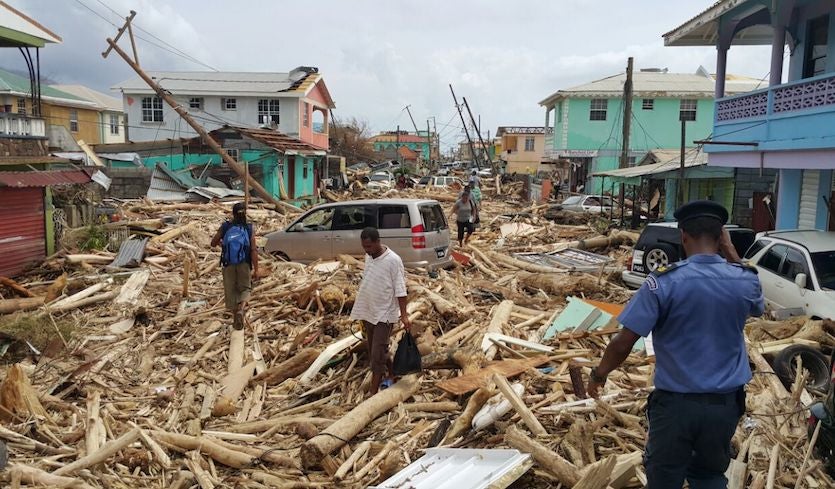
Cat 4 Hurricane Laura 2020

Meanwhile SPC is contemplating higher TOR probs for Tenn. Oxford, Miss had a tornado at 6:30 am. The MD around 7 did not anticipate a watch, but that's still an early MD.

Agree with SPC the wind field is spreading out over some good CAPE areas. First thought was Kentucky backed winds. Looks like CAPE will be best in Tenn. Plus some southwest winds moving out. Also some morning showers Tenn could help with more boundaries. Still would not rule out Kentucky though. It's all just up I-24!
 
Back home after two long days of driving. Sounds like all serious chasers made good decisions with this storm and I've not heard of any "bonehead" reports. The US coastal threat level will be low for the next 10 days or so.

Hotels.... I felt very comfortable in hotels. I only used IHG properties and stayed mostly on ground floor rooms by pre-request to avoid elevators, or I took the stairs. I decontaminated the rooms with Lysol spray and disinfecting wipes, while covering all bedding with disposable plastic sheets. I used my own covers / pillows. Occupancy levels were VERY low and I don't recall passing a single person in the hallway for the entire week period. It was kind of nice to have a luxury room on the beach in Galveston for $100.00 per night instead of the usual $400.00 per night rate.
 
Last edited:
Any followup on this?
I have made no attempt to follow up except I have continued to read every single post on that thread ever since, even up until this morning. There has been no mention of it ever since, and I haven't seen anything about it anywhere else, either. I think at this point it's safe to say it was not true, or they got "saved" right away.
 
I did hear some reports of chasers (and others) running out of gas in the strike zone, so maybe "rescue" was a figure of speech.

Except he didn't say they were rescued... He said they called 911 reporting they were trapped. Running out of gas doesn't cause your car to trap you :)
 
Warren, are you posting a report of your chase anywhere?

There are some jawdropping helicopter videos on YouTube. Is it becoming uncool to use the word epic? Anyway, here's one I saw today that is making me compare this to Andrew. Watch it at full HD and full screen:

(4) 8-27-2020 Hurricane Laura helicopter video of Cameron, La aftermath - YouTube

Impressive video. Interesting at about 0:49, there is a fairly large building in the foreground that looks almost untouched, not even any roof damage.

There are a number of foundations that appear to have been swept clean. I would say it looks like EF5 tornado damage, except that it may have been the result of surge as opposed to wind.

Wish there was a way to compare before and after. Although there is clearly water where there is not supposed to be water, it’s a marshy lowland area, so it’s hard to tell exactly where the normal waterline is. I couldn’t even tell in what direction or how far away the Gulf was in most of the video. I am fascinated by storm surge, it is almost impossible for me to visualize the ocean going from”here” to “there” the way it does, and it’s a phenomenon that can never really be captured on video. Doing it from the ground would be unsafe and also wouldn’t capture the scale or perspective. Doing it from a helicopter or drone would be impossible (or at least unsafe) during the height of the storm.
 
It was a 4. Land-based METARs can't detect the winds over water when it was at full strength.

I checked a couple of the NOAA buoys and didn’t see readings that impressive there either. Admittedly, this is just anecdotal and I am not claiming to have done any real research, but would be interesting to go back and look at if anyone is so inclined. But I was having a similar thought to @Stan Rose , surprised I couldn’t find any reports of sustained winds in the Cat 4 range.
 
It should be documented as a cat 4 based on the officially analyzed maximum sustained winds in the last NHC advisory just before landfall. I believe that is how they are rated regardless of any actual measured surface winds on land. There has been much discussion today on various groups as to what goes on with overland wind speeds in landfalling hurricanes.

Check these articles: Hurricane Winds at Landfall: A Measurement Challenge

Just now had a chance to read the first article. I find this subject quite interesting and always wondered why we never seem to get land observations that confirm the NHC forecast.

I’m not sure what to make of this quote from the first article:

“(Josh) Wurman’s sense is that few if any people—even right on the coast—will experience sustained winds on par with the NHC ratings for a landfalling hurricane. “Even if the open ocean values are correct, they are extremely non-representative,” he added. Wurman uses this rough analog: if a midlatitude winter storm producing 120-mph winds atop Mount Washington were heading toward Boston, the local forecast probably won’t leave Bostonians thinking they might experience the same wind. “NHC should make clear what scientists and engineers know is true—that max gusts over land will be near or below their open-ocean sustained-wind estimates.” “

The analogy implies that it’s an issue of height where the wind speed is measured. But my understanding is that NHC accounts for that, don’t they apply mathematical formulas to derive surface winds from higher-level flight readings and satellite measurements?

The concluding quote from Marty Bell seems to contradict Wurman anyway:

“When the over-water storm estimate and inland observing environments are reconciled, we find that the differences are not as great as they initially appear. This has important ramifications [for] public safety, the insurance industry and others since there is a widely-held belief that the NHC often over-estimates storm intensity by a category or more.”

I guess the “reconciliation” involves accounting for friction over land, but if so then shouldn’t this effect be made part of NHC’s wind speed estimates for forecasting purposes?

So I’m left without much clarity, except to realize that it remains a mystery at best, perhaps it can even be called a controversy?
 
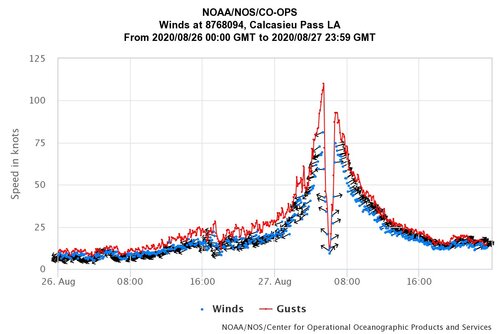
I found this near Calcasieu Pass, Louisiana (Cameron area) during the passage of Hurricane Laura. It appears at least one site was able to make it through the intense hurricane force winds, the eye, and then the other side. It looks like the peak gust at this site was around 127 mph and peak sustained wind of 90-100 mph. I'm not sure the exact source of this graph other than the data is from NOAA, but based on looking at peak gusts from the same site on the NWS site, it appears to be of somewhat credibility...

I think to me in that video above, the most impressive damage is the broadcast towers that are knocked down and then the couple homes I see that are swept away (but that could be surge based). Them towers are built to withstand quite a bit, yet we did lose several in Iowa here a few weeks ago as well. Does this single site represent the entire hurricane? No. The highest sustained winds and gusts I could find at Lake Charles were similar (sustained at 98 and gusting to 133.5 mph). There was some intense eddies and mesovortices within the inner eyewall and eye it appeared like though, so this could explain some of the sporadic damage (one home barely damaged and the next completely destroyed). The ASOS at Lake Charles failed though shortly after the inner eyewall passed and the radar was downed, so we don't have any data for the back half of the hurricane.

At the cost of trying not to sound too morbid, looking at the list of fatalities, it appears as though with some education and harm reduction, some of these could have been easily prevented. Some were from falling trees, while many others were from Carbon Monoxide poisoning due to generator use (8/14 so far).

I won't argue about what category it was when it passed over what location and such. Although I do believe areas further inland took it less on the chin than expected, even with such heavy areas of wind damage. Sure 120-140 mph wind gusts can cause a lot of damage, but it certainly could have been A LOT worse for the Lake Charles area looking at some of the damage video. As for coastal areas, its hard to differentiate between wind damage and surge and I'm sure NHC will release their post-storm report and help us shed some light on that.
Eyewall of Laura.jpg
 
Those are interesting points made by Jim and Ethan, but I think the one thing you are overlooking, more than any other, is just how narrow the band of highest winds usually is and how unlikely it is that those highest winds find an observation station that is able to survive and record them. I'm thinking of all hurricanes, not just Laura.

I know that I, personally, until a few years ago, always kind of pictured a hurricane as being this huge thing producing 100+ mile winds that scoured the earth for 20, 30, 50 miles across a damage path, but I know now that that is not the case. There is only a very (relatively speaking) narrow band of the highest winds in a hurricane's eyewall, and then pretty much only in the right-front quadrant, too. I believe, and this is based on many many hours of reading stuff on the internet over the last 20 years, that the band of the top 10mph of winds is typically only one or two hundred yards in width, much like a large tornado.

Maybe I'm wrong, but I believe it to be true. That would explain why ob stations never seem to catch the highest winds per HH/NHC data, whereas with all the equipment and skill that the HH's have and the fact that they penetrate the hurricanes perpendicularly they are able to find those (sustained) wind peaks. The HH's use of sondes and SFMR makes me trust their data.

I'm not saying that the hurricanes only have a band of damaging winds the size of a tornado. Of course they do far more damage than that, but it mostly comes with winds that are a category or two less than what the NHC is saying, as everyone else is saying in this thread.
 
Back
Top