• A friendly and periodic reminder of the rules we use for fostering high SNR and quality conversation and interaction at Stormtrack: Forum rules

    P.S. - Nothing specific happened to prompt this message! No one is in trouble, there are no flame wars in effect, nor any inappropriate conversation ongoing. This is being posted sitewide as a casual refresher.

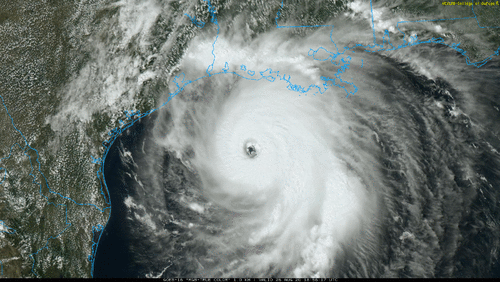
Cat 4 Hurricane Laura 2020

Warren Faidley

Supporter
Joined
May 7, 2006
Messages
2,305
Location
Mos Isley Space Port
Really surprised no one has started this thread yet. Tropical Storm Laura's banding is looking increasingly impressive / expansive on satellite and it has the "look" to go "BIG" in a very short time frame. Lack of up-welling and /or shear from Marco is not a negative factor. I'm based in Galveston, TX ATM. Monkey wrenches are obvious, "long-range" forecast suggests a "dark swamp" storm effecting the unchaseable LA coast unless you are mental / desperate. Option B is to head to Gulfport / Biloxi, MS tomorrow AM if it moves east and hits in daylight. Everyone be safe, the LA coast is a nightmare --- Katrina was a Cat-3 with a Cat-5 surge of 20+ feet.
 
Not much new to report from Galveston. Seen several out-of-region rescue crews in town and a handful of local media. Hope things don't change too much re: path and intensity as most locals are NOT taking Laura seriously. If Laura goes ultra-jiggy and hits this area, it's going to be an epic disaster. There are still a few models showing an onshore eyewall here.
 
Warren, I've been sharing similar concerns as well. Everyone looks at the current models and are assuming it won't affect the Houston area. My dad has a house down there so we'll be keeping a close eye on it, but I will be in Fredericksburg and far enough west that I doubt I even see any rain out of it.
 
Big problem is the forecast path involves a curve to the north at the last moment -- not uncommon. This **often** does happen as systems round highs or troughs nudge storms N/NE. If that turn does not happen -- there will be no time for corrections. If the high holds or builds even a tad, it's a big shift this far out. It's also going to be very hard for chasers to get from LA to Galveston at the last moment due to traffic. Just remember the ferry closes early when a storm threatens.
 
There doesn't seem to be much standing in the way for Laura to undergo rapid intensification while in the gulf, and the NHC still professes to struggle at forecasting intensities, do they not? I have seen SST's higher than present, but it's plenty juicy out there, and shear apparently won't be a detriment. Hurricane Frederic took a similar route in 1979, was a TS in almost exactly the same spot over Cuba, and became a CAT4 well before making LF S of Mobile. Do I believe Laura will do the same? No... I have no idea what Laura will do.

 
There doesn't seem to be much standing in the way for Laura to undergo rapid intensification while in the gulf, and the NHC still professes to struggle at forecasting intensities, do they not? I have seen SST's higher than present, but it's plenty juicy out there, and shear apparently won't be a detriment. Hurricane Frederic took a similar route in 1979, was a TS in almost exactly the same spot over Cuba, and became a CAT4 well before making LF S of Mobile. Do I believe Laura will do the same? No... I have no idea what Laura will do.


The upper level outflow and satellite presentation looks like it's just waiting to clear Cuba to go nuts.
 
Not much new to report from Galveston. I'm safe from a Cat-4+ in "Neptune's Sea Castle." Forecast path continues to move ever so slightly south. Hurricane and Storm Surge Warnings for Glaveston + mandatory evacuation. Should be enough light to photograph Thursday AM, similar to Andrew.

Chasers.... be very careful if taking the ferry to Galveston via HWY 87. Crystal Beach floods quickly (well in advance of a storm) and I was nearly death-trapped there during Ike and just made it on the last ferry. (Crystal Beach was moonscaped).

Good luck to everyone, be safe, smart and I'll report back when I can or live via twitter.
 
Edit... In Galveston... Looking like the main show **could" be in the dark unless something dramatically changes with the landfall timing, which is not likely. I estimate there will be some on-shore flow before dark, then offshore after dark. If it changes speed and moves south, or stalls, then all bets are off, or if it turns north sooner, it's a swamp-eater. A lot will depend on how strong it gets, but there is not a lot of time for that. Nor is there time to build a massive wave surge.
 
I was just looking at IR, and Laura seems to be working on getting her sh** together, but is already almost halfway from Cuba to the TX/LA coast and has only strengthened from a TS to CAT1 so far... not that much time has elapsed. She's moving at 15kt, which is a pretty good clip. At the rate she's going she is just going to barely become a mature hurricane when she runs into a bit of shear, and then the coast. The forecast for LF at ~105kt seems pretty reasonable to me.
 
I am curious to hear what Warren now plans for tonight, given the talk of "unsurvivable surge" and that the surge has the potential to reach I-10. There's never any shortage of hyperbole during any event like this!
 
I should have been clearer. I didn't mean "unsurvivable surge" is hyperbole. Anyway, rumor has it that Jeff Piotrowski is reporting 911 calls from chasers who are trapped in their cars. (already)
 
Thanks for clarifying...

I've been watching Jeff's Twitter feed and he's been doing a lot of updates but nothing about trapped chasers. Where would that even be?
 
Hmm... interesting... Well I guess I can't say it's not true, but it's strange that Oakhurst_Wx knows more about what Jeff is saying than what Jeff is saying :) Thanks either way. It's going to be a doozie.
 
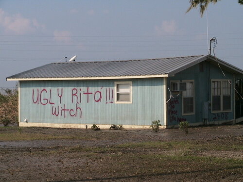
This is all so very deja vu-ish for me. I spent several days before, during and after Rita in the gym of the DeRidder High School, about 40 miles N of Lake Charles. Can't stop thinking about that.

050929_2043zSmall.JPG
 
Per Tropical Tidbits, latest air survey estimates 150~155 surface winds.
And Radarscope has a few ~200MPH pixels, at height of course. How reliable are those 'hot pixel' readings likely to be?
Given its presentation last night, I thought it would strengthen significantly, but....
 
We had made plans to chase Laura but given the midnight landfall, prospect of having to be 35 miles inland due to high surge, and again being dark we decided to hold off and sit out. I’Normally I’d be a bit bummed about missing a big event, but I’m not. If it comes onshore near Cameron LA, I’m really concerned many of those coastal communities in the wildlife area down there could be completely underwater with 20 foot of surge and already being below sea level.
 
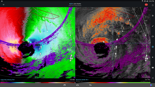
Screen capture velocity vs spectrum width showing a 200+ pixel. During Michael I had a similar question and was told to use spectrum width to verify. It doesn't show in spectrum width so does that mean it's a false signal?
 

Attachments

  • Screenshot_2020-08-26-21-46-28.png
    Screenshot_2020-08-26-21-46-28.png
    1.1 MB · Views: 0
Screen capture velocity vs spectrum width showing a 200+ pixel. During Michael I had a similar question and was told to use spectrum width to verify. It doesn't show in spectrum width so does that mean it's a false signal?
I’m not an expert on radar by any means, but I’ve taken a couple weather instruments courses for my degree and I believe that’s in an area of reflectivity/velocity folding, so it’s probably not accurate. Someone correct me If I’m wrong, but that’s what we were taught that was.
 
All I know is that GRL3 is indicating values of about 63kts from the same data. Same pixels. 0.5° velocity scan. I'd like to know what's going on, too.
 
Generally velocity pixels with values scattered within range-folded areas are very suspect. Likely bad.

Velocity display/sampling in the 8bit Level 3 products is cutoff at 123 kts. GR2Analyst doesn't have that cutoff and can display velocity values well above 123 kts.
 
Back
Top