-
While Stormtrack has discontinued its hosting of SpotterNetwork support on the forums, keep in mind that support for SpotterNetwork issues is available by emailing [email protected].
You are using an out of date browser. It may not display this or other websites correctly.
You should upgrade or use an alternative browser.
You should upgrade or use an alternative browser.
Cat 4 Hurricane Laura 2020
- Thread starter Warren Faidley
- Start date

Bob Schafer
EF5
I've been watching Jeff's Twitter feed and he's been doing a lot of updates but nothing about trapped chasers. Where would that even be?
I'm basically just re-posting what I read on another forum (americanwx). It came from here, though:
rdale
EF5
Hmm... interesting... Well I guess I can't say it's not true, but it's strange that Oakhurst_Wx knows more about what Jeff is saying than what Jeff is saying ") Thanks either way. It's going to be a doozie.
Thanks either way. It's going to be a doozie.
Thanks either way. It's going to be a doozie.Bob Schafer
EF5
This is all so very deja vu-ish for me. I spent several days before, during and after Rita in the gym of the DeRidder High School, about 40 miles N of Lake Charles. Can't stop thinking about that.

Greg Campbell
EF5
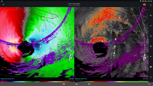
Per Tropical Tidbits, latest air survey estimates 150~155 surface winds.
And Radarscope has a few ~200MPH pixels, at height of course. How reliable are those 'hot pixel' readings likely to be?
Given its presentation last night, I thought it would strengthen significantly, but....
And Radarscope has a few ~200MPH pixels, at height of course. How reliable are those 'hot pixel' readings likely to be?
Given its presentation last night, I thought it would strengthen significantly, but....
Ethan Schisler
EF5
We had made plans to chase Laura but given the midnight landfall, prospect of having to be 35 miles inland due to high surge, and again being dark we decided to hold off and sit out. I’Normally I’d be a bit bummed about missing a big event, but I’m not. If it comes onshore near Cameron LA, I’m really concerned many of those coastal communities in the wildlife area down there could be completely underwater with 20 foot of surge and already being below sea level.
David Cox
Enthusiast
Ethan Schisler
EF5
I’m not an expert on radar by any means, but I’ve taken a couple weather instruments courses for my degree and I believe that’s in an area of reflectivity/velocity folding, so it’s probably not accurate. Someone correct me If I’m wrong, but that’s what we were taught that was.Screen capture velocity vs spectrum width showing a 200+ pixel. During Michael I had a similar question and was told to use spectrum width to verify. It doesn't show in spectrum width so does that mean it's a false signal?
Bob Schafer
EF5
All I know is that GRL3 is indicating values of about 63kts from the same data. Same pixels. 0.5° velocity scan. I'd like to know what's going on, too.
Generally velocity pixels with values scattered within range-folded areas are very suspect. Likely bad.
Velocity display/sampling in the 8bit Level 3 products is cutoff at 123 kts. GR2Analyst doesn't have that cutoff and can display velocity values well above 123 kts.
Velocity display/sampling in the 8bit Level 3 products is cutoff at 123 kts. GR2Analyst doesn't have that cutoff and can display velocity values well above 123 kts.
The purple area in that radar image implies there is range folding going on. The NEXRAD network radar product generators have algorithms for accounting for this, but they're not perfect. I am not 100% sure what it means if reflectivity is range folded but velocities are clean. Using spectrum width can be helpful, but it will not say "yes"/"no" on validity. SW only tells you the relative degree of certainty of the singular value in velocity. Remember: spectrum width is the standard deviation of the Doppler spectrum at that location.
Stan Rose
EF5
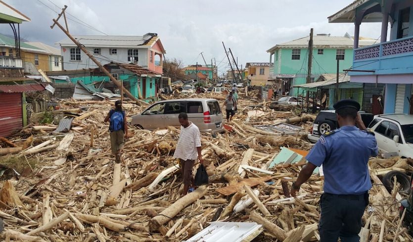
So was Laura a Cat 2 or 4? highest recorded sustained winds were 98mph, with a few gusts in the 125-135 range. Not Cat 4. The Cat 4 was based on satellite and aircraft just prior to landfall, doesn't really say what Lake Charles experienced. Looking at damage pics though it was at least a Cat 3.
It should be documented as a cat 4 based on the officially analyzed maximum sustained winds in the last NHC advisory just before landfall. I believe that is how they are rated regardless of any actual measured surface winds on land. There has been much discussion today on various groups as to what goes on with overland wind speeds in landfalling hurricanes.
Check these articles: Hurricane Winds at Landfall: A Measurement Challenge
Check these articles: Hurricane Winds at Landfall: A Measurement Challenge
Hurricane Winds at Landfall: Why Is It They Seem to Fall Short?
For a variety of reasons, land-based observations seldom live up to a hurricane’s Saffir-Simpson ranking at landfall.
www.wunderground.com
rdale
EF5
So was Laura a Cat 2 or 4? highest recorded sustained winds were 98mph,
It was a 4. Land-based METARs can't detect the winds over water when it was at full strength.
Warren Faidley
Supporter
Got super busy with decisions, media stuff and shooting so I did not have time to check back in. I believe the "non-survivable" surge never occurred for several reasons, but mostly because Laura's explosive development occurred too late to generate large, wind-driven waves in conjunction with moving too fast. With most major hurricanes I've covered, like Katrina, the water began rising way in advance of the storm. We did not see that pre-storm rise in water with Laura, so I was not surprised to hear the "Godzilla surge" never occurred. I only had a very brief moment to check wave heights with Laura, something I always do when estimating surge safety. I believe Katrina may have produced waves of 32m / 100 feet, as did Andrew (?). I did not bother to head east to the destruction zone, as it appeared outside help was not needed and I did not want to get in the way -- and run out of gas. There will be more Gulf storms this year, no doubt.