• While Stormtrack has discontinued its hosting of SpotterNetwork support on the forums, keep in mind that support for SpotterNetwork issues is available by emailing [email protected].

Largest Observed SRH?

Randy Jennings

Supporter
Joined
May 18, 2013
Messages
835
Does anyone know what the largest observed Storm Relative Helicity values are? I have searched online and can't find it. NWS Fort Worth is doing a presentation at some of the larger Slywarn training sessions on the Oct 20, 2019 Dallas tornado and it includes an ACARS sounding from an aircraft that took off from Dallas Love Field 1 minute before the tornado (in the inflow region). It measured 1003 m2/s2 SRH in lowest 3km and 883 m2/s2 SRH in the lowest 1 km. They are also going to present this at TESSA this year.
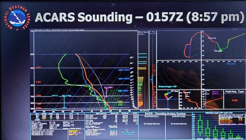
20200215_181533.jpg
 
This may indeed be the largest sampled 0-3 km and 0-1 km storm relative helicity (SRH) within the local environment of a tornado-producing storm. Research from the 1995 Vortex indicate the highest values of 0-3 km SRH were ~ 450 m**2/sec**2 (http://www.meteo.psu.edu/~pmm116/pubs/1998/MSRB98MWR.pdf). A study of the May 22nd, 2008 Winsor, CO tornado indicated a 0-3 km helicity value of 430 m**2/Sec**2 (https://journals.ametsoc.org/doi/pdf/10.1175/WAF-D-15-0105.1. I seem to recall a study from the May 4th, 2007 Greensburg, KS event that calculated SRH values near 650 m**2/Sec**2, but I could not find the manuscript. The base data for the calculation was taken from a radiometric profiler.

Accuracy of ACARS data has been deemed fit for calculating severe weather parameters (https://journals.ametsoc.org/doi/full/10.1175/1520-0434(1999)014<1032:AOAWAT>2.0.CO;2), so it would be difficult to deny the validity of the calculated SRH in this case.

I am planning to attend TESSA again this year and look forward to this presentation by the NWS Ft. Worth
 
I have been waiting to see if anyone would mention hurricanes. I have noticed some extreme srh numbers during hurricane landfalls, and Randy probably didn't start this thread to talk about that, but he didn't say "I don't mean during hurricanes" either.

So, what I did was check the mesoanalysis archive for the first one that came to mind: Katrina. If you look at that, you'll see that mesoanalysis said it was easily over 1000. If anyone really wants to find huge srh numbers, I'd suggest you start researching hurricanes. Click on the link below to see what they have for Katrina.

 
Those aren't observed though as far as I know?
Here is a study on severe weather parameters from land-falling hurricanes in the Gulf of Mexico. It looks like these were based on measured winds from rawinsonde releases in the tornado-favored northeast quadrant of the cyclones just prior to landfall. Table 3 has a few SRH values in the 600 to 800 range, but with a large standard deviation between the cases.

 
That sounding from DFW indicates something I've suspected for a while now, which is that the vorticity values in tornadic supercells climb to truly insane levels. Given that this was an EF-3 tornado one would suspect that the most superlatively violent tornadoes could easily push 1500+ at the occlusion point.
 
Has there ever been a hurricane that made landfall during what would be called High Risk outbreak?
 
On March 2nd 2012 there was SRH values over 1000 m2s2 in Eastern Ky. Likely higher within narrow valleys. Interestingly a 60 mile long EF-3 and a 49 mile “high-end” EF-3 occurred in this environment with CAPE less than 500 j/kg.
 
Has there ever been a hurricane that made landfall during what would be called High Risk outbreak?

No. The conditions that are favorable for prolific/intense tornado production in landfalling TCs usually come together with insufficient lead time/predictability to warrant a high risk. In other words, most landfalling TCs will produce at least a few tornadoes, but most will not produce large numbers of them/produce the long-track, strong to violent ones associated with a high risk.
 
Back
Top