JamesCaruso
Staff member
Looks like a potential volatile setup on Sunday, although not in our traditional chasing region and likely not ideal from a storm mode perspective anyway, given strong forcing from a cold front and the exit region of a strong 500mb jet.
My main reason for posting - and MODs feel free to move it if appropriate - is an opportunity to highlight something that always perplexes me: being unable to reconcile what is in an SPC outlook with what I am seeing in the models. Sometimes SPC does not reference specific models and just talk in generalities, so if I can't see it in one specific model it usually doesn't trouble me. But here, they specifically reference the NAM (this is the Day 2 outlook issued at 06Z on 6/24):
"NAM forecast soundings in the vicinity of Louisville, Kentucky in the late afternoon, beneath the nose of the mid-level jet, have MLCAPE peaking near 4000 J/kg. 0-6 km shear is forecast to be near 50 knots, with 0-3 km storm relative helicity generally near or above 300 m2/s2. "
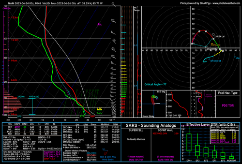
So from Pivotal Weather I pulled a 48-hour NAM sounding for Louisville Kentucky - run at 0Z on 6/24 (should be the latest version available for the 06Z Day 2 outlook) and valid for 0Z on 6/26 (the evening of Sunday 6/25). This is shown below.
MLCAPE over 4400 - I guess "peaking near 4000" makes sense. But 0-6km shear is shown at 65 in the sounding, vs 50 in the outlook. 0-3km SRH is shown at 508 in the sounding, significantly higher than "near or above 300" in the outlook.
The sounding parameters for 21Z are less impressive, but I think SPC is intending to (and should be) referring to the time things peak.
This is not intended to be critical of the SPC outlook. I am just trying to understand why things don't seem to match. Am I looking at something incorrectly? Is it a NAM "version" issue of some sort? Does SPC blend in other model solutions to offset NAM biases, even though specifically referencing the NAM?

