History of station plots

Joined
Dec 4, 2003
Messages
3,411
I was doing some research today to find the history of surface station plots as we know them.

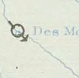
From 1870 up until 1941, the U.S. Signal Service and U.S. Weather Bureau used this format in their Daily Weather Map series:
1941old.gif


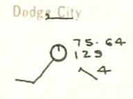
In 1941 they revised it to this curious format:
1941new.gif


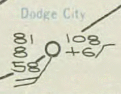
After a year, they changed it to this familiar version in 1942, which is now in universal use:
1942new.gif


I was surprised to see evidence that the modern station plot was not in use until the 1940s. Unfortunately many of my books are still boxed up from the move. I'm wondering if anyone knows anything regarding the history of station plots, and if they arose out of an unwritten standard. I figure the International Meteorological Organization (predecessor to WMO) may have encouraged the format, but the weird 1941 format makes me think the Weather Bureau may have developed it.

Tim
 
That is an interesting question. I don't really know who developed the modern format for the plots, but I did notice the differences between the different time frames you mention.

It is also fun to look back at daily weather maps that had hand plotted symbols! Not that there is anything wrong with computers doing the job today, but I know you would agree the maps produced by hand possessed a much more "human" look :)

Pat
 
I tried looking at the AMS Allen Press archives and came up empty handed. One paper I found from the 1930s used the ancient plot symbol. It's really odd that nothing (apparently) was published about this when the agencies changed over. I'm not sure how far back Weatherwise goes but if I had a stack of old issues I suppose I'd start looking in there, since it was a little more technically advanced then than it is now.

Tim
 
It is odd this has never been addressed before...although it may have been in some older/obscure literature.

Might not hurt to email the document retrieval people at NOAA to learn what they might know on the subject?? I might give that a shot...

Funny how some people just look at an older chart without wondering about why it looks the way it does until somebody else brings it up LOL

Pat
 
I emailed Doria Grimes. Guess we'll find out if they know anything on the subject.

Pat
 
Odd, I E-mailed her Thursday; no response yet. I guess maybe two of us will budge her. :)

Tim
 
I got this reply earlier today. Guess it shall remain a mystery!

Tim


Tim,

Your question concerning the station model was passed on to me in the
Hydrometeorological Prediction Center. Since we are responsible for
preparing the Daily Weather Map, as well as operational surface charts,
we were a logical resource.

I’m sorry to say you stumped us. I’m sorry it’s taken so long to reply,
but no one in the HPC was aware of the different station model used
briefly in 1941 and I’ve tried to contact some of the “old timers†who
might remember, but so far nobody has stepped forward. I’ll let you
know if I discover anything.

The consensus is that the station model used prior to August 1, 1941 was
probably a U.S. standard. The one in use after August 1, 1942 was
almost certainly a WMO standard. But we don’t know if the one in use
between those dates was a U.S. modification of the WMO standard and we
later switched to the WMO standard or if it was the WMO standard at the
time and the WMO standard changed. We have no documentation here that
would shed any light on this.

Ed Danaher
 
Back
Top