Derecho?

John Farley

Supporter
Joined
Apr 1, 2004
Messages
1,898
Location
Pagosa Springs, CO
In reference to yesterday's storms in northern Illinois, Colin Davis wrote in yesterday's NOW thread:

"Just to clear things up, though, derecho is not the term to use here. Nor is it in 95% of the cases the term is used to describe, but that's another story for another time."

Why not? As I understand it, the definition of a derecho is an MCS that produces damaging wind along a very long track, i.e. hundreds of miles. In yesterday's case, the MCS developed near the Iowa-Illinois state line and produced damaging wind from there toward the ENE all the way across Illinois and on a good distance into southern Michigan and across northern Indiana:
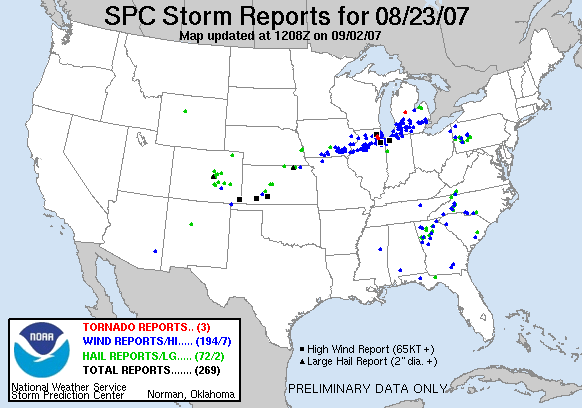
070823_rpts.gif


Some of the Michigan reports are from other storms ahead of the main MCS, but damage from the MCS was pretty continuous all the way across Illinois and Indiana. FWIW, Dr. Greg Forbes today referred to the storm as a derecho, and that seems correct to me. If not, someone please inform me why not.
 
[FONT=Arial, Helvetica, sans-serif] The second type of derecho is called a "progressive" derecho and it is associated with a relatively short line of thunderstorms (typically from 40 miles to 250 miles in length) which may at times take the shape of a single bow echo, particularly in the early stages of development. In some cases, the width of the progressive derecho and its associated bow echo system remain relatively narrow even though they may travel for hundreds of miles.[/FONT]
[FONT=Arial, Helvetica, sans-serif]
[/FONT]
[FONT=Arial, Helvetica, sans-serif]By definition winds in a derecho must meet the National Weather Service criterion for severe wind gusts (greater than 57 mph) at most points along the derecho path. In the stronger derecho events winds can exceed 100 mph.[/FONT]
[FONT=Arial, Helvetica, sans-serif]

By SPC's definition, yesterday's event would qualify.

Other events that qualify: http://www.spc.noaa.gov/misc/AbtDerechos/annualevents.htm

Some people have different perceptions. I've seen people who would classify only those events such as May 31, 1998 and October 24, 2001 as derechos... with everything else being sub-derecho. I guess it depends on your personal preference, but I stick with the SPC definition.
[/FONT]
 
As I recall, the definition of a derecho is a widespread damaging wind event(usually long lived) from a single MCS/cluster of storms with winds generally over 70 mph(what someone from the NWS told me a while ago). So by that unofficial definition it would also qualify. I too would like to know why yesterday would not be generalized as a derecho? At 4 pm we got hit with the derecho.....then at 7 pm we got hit by a weaker MCS.
 
Well... the +325 mile track was enough of a qualifier for me. By the time it reached my location just north of Detroit, it was in a weakening phase, but still enough to produce many damage reports with +60MPH winds. The gust front was incredible, although I didn't experience any significant gusts from it.

So... we have a series of bow echoes that traverse 325 miles at speeds reaching 65mph, several significant damage and wind reports from LOT to GRR, with many reports AOA 57mph after that.

I would say that meets the qualifications of a derecho.
 
I understand what Colin is saying... this one is kinda borderline. While it did have a fairly long path, I think the term "derecho" is supposed to be saved for the biggest of the big. Not only should it be widespread/long lived damaging winds, it should be widespread/long lived SIGNIFICANT wind damage. While yesterday's winds were certainly intense, I only see 3 reports of damaging winds over 65 kts. While yesterday's event also wasn't short lived, I also don't think it was an extraordinarily long lived event either. It was a good distance, but in that area again I think derecho is generally saved for the events that really make you sit back and say, wow.

1995jul12-13rpts.jpg


Okay, so the above is a fairly extreme example... but that's more of what I imagine when I start hearing the term "derecho" thrown around. Not so much a bow echo that produces a couple sig. wind events and travels from IL to southern MI.


Maybe this one could be argued as a bow echo, I'm certainly not saying anyone here is wrong in calling it that, I'm only saying I see where Colin is coming from. I do think that the term is thrown around way too losely anymore. It seems anytime a bow echo forms and produces a few good wind damage reports, people begin immediately calling the complex derecho. Again, not saying anyone is just throwing it around by calling yesterday's event one as it certainly was a good arguable case... I'm talking about many events in the past that didn't even end up being very intense bow echos. Seems a mean bow echo on radar is a derecho today.
 
Last edited by a moderator:
There were significant winds in places that don't show up in the preliminary LSRs. For example, a damage survey from DVN estimated winds at 100 mph in a small town in west-central IL where 200 homes were damaged, and there were likely also winds of 80 mph or higher in the Galesburg/Knox County area.
 
Just like tornadoes, I believe derechos come in different strengths. The image posted by Andrew is obviously an extreme example... I believe yesterday's event could be considered a weak derecho.

I'd like to know what are some of your exact definitions? More than 50 reports from a particular MCS? More than 100 miles long? More than 5 significant gusts? A combination? All of the above?

Here's another example of an extreme event:

act-plot.gif


My personal definition for a derecho is >150 mile long track during the mature stage, at least 60 miles length-wise, and several significant wind reports (+65knts). The total number of reports doesn't matter to me because there are areas not well covered by spotter networks.
 
I suppose I can compare it to tornadoes in a way as well. I guess I consider derechos to be the same as significant tornadoes. Bow echos come and go, just as those weak tornadoes do. So then I generally save the derecho term for the major attention drawing complexes, like significant tornadoes. Without a set of criteria it's hard to distinguish what is and is not a derecho, but as I said above, with a path as long as the bow echo yesterday took I'd like to see more than 2, 3, 4, significant reports. While total reports is important, I think the ratio of significant reports to total reports is more important.
 
Ahhhh...one of my biggest pet peeves. The term "derecho" gets thrown around wayyyyyy too often and I think yesterday was no exception. Sure, it was a strong wind event but in no way met classic derecho criteria. Personally, I look for a line that is 200-250 miles long atleast, produces atleast 10 reports of winds greater than 90mph, and the lifetime of the line is greater than 12 hours. Sure, those criteria are hard to meet but that's why the term is there because it's a rare event. Just because there was a localized report of winds greater than 90mph doesn't mean that it automatically picks up the name derecho. The W. Texas event on June 26th is another classic example of people throwing out the term too loosely.

I also can't stand it when people use the term "mini derecho"
 
i will go with what the SPC says and in my opinon what happened in Chicago was a progressive derecho


"By definition winds in a derecho must meet the National Weather Service criterion for severe wind gusts (greater than 57 mph) at most points along the derecho path"

and from the LOT damage survery

ALONG THIS PATH...WIND DAMAGE WAS CONSISTENT WITH
WINDS IN THE 60 TO 80 MPH RANGE. HOWEVER...THERE WERE POCKETS OF WIND DAMAGE SUGGESTIVE OF WINDS IN THE 80 TO 100 MPH RANGE INCLUDING THE 4200 BLOCK OF NORTH ASHLAND AND ACROSS NORTHERN GLEN ELLYN SOUTH OF GENEVA ROAD. THE WIND DAMAGE WAS APPROXIMATELY ONE HALF MILE WIDE ALONG THIS PATH. A SEPARATE AREA OF WIND DAMAGE SUGGESTIVE OF WINDS OF 80 TO 100 MPH WAS FOUND IN THE 4000 BLOCK OF NORTH SHERIDAN IN THE WRIGLEYVILLE AREA WITH EXTENSIVE TREE DAMAGE AND SEVERAL UPROOTED TREES IN THIS AREA

i wouldnt be surprised if there were other pockets in the mount prospect and Morton grove areas in the NW burbs as well
 
"By definition winds in a derecho must meet the National Weather Service criterion for severe wind gusts (greater than 57 mph) at most points along the derecho path"

i wouldnt be surprised if there were other pockets in the mount prospect and Morton grove areas in the NW burbs as well

By what you're going off of, the NWS offices in North Carolina had better get out the warnings for the derecho there. You are talking about isolated pockets of winds of 80-100mph.....not widespread reports. Unless you consider the NW Chicago suburbs a widespread area. A supercell can produce isolated wind gusts of over 80mph....does that mean a supercell is a derecho if it does?

derechomyarse-1.jpg


Last edited by a moderator:
By what you're going off of, the NWS offices in North Carolina had better get out the warnings for the derecho there. You are talking about isolated pockets of winds of 80-100mph.....not widespread reports. Unless you consider the NW Chicago suburbs a widespread area. A supercell can produce isolated wind gusts of over 80mph....does that mean a supercell is a derecho if it does?

pockets of 80-100 mph winds with widespread reports of severe thunderstorm strength winds (under 80) and by definition would be more than enough for a progressive derecho

never did i say that the nw burbs were the only location and if you would take a look at the storm reports from that day, you would see that severe wind reports came in from as far south as Bourbanais 40 + miles south of Chicago to northbrook, 20 miles to the north of Chicago. there were damage reports all along the line from north to south

Supercells also can enhance winds inside derecho's and that is possibly what happened over dupage and central cook counties
 
08/23/07 derecho

The severe weather event of 08/23/07 was a derecho its as simple as that! lol :D
To me, if Dr. Greg Forbes say's its a derecho and it meets SPC's criteria then its a derecho its really not that complicated people. :rolleyes: :D
 
I see where Andrew and Darin are coming from... Yet I see that this event meets the requirements defined by the SPC.

Just like an MCC has a rather exact definition, I think the definition of a derecho should be further refined... preferably the distance of the path, forward speed, length of the overall line itself... as defined by reports of SVR criteria wind.

As with any event, you would undoubtedly end up with weak derechoes (those just barely meeting SVR wind criteria), and you would end up with extreme derechos (many high-end wind reports)... but as long as it meets the dimensional specifications, it's a derecho.
 
It is not just a handful of significant wind reports in the Chicago suburbs. As the following PNS and LSR links indicate, there were reported winds of 80 mph or more in four different CWAs. While I have seen no PNS yet on the damage in the Galesburg, IL area, media reports of the widespread and major wind damage and of interviews with NWS personnel suggest winds in the 80+ mph range over a sizable area in and around Knox County in western IL.

From LOT:

http://kamala.cod.edu/il/latest.nous43.KLOT.html

From DVN:

http://kamala.cod.edu/offs/KDVN/0708232230.nous43.html

From ILX:

http://kamala.cod.edu/offs/KILX/0708232133.nwus53.html

From IWX:

http://kamala.cod.edu/offs/KIWX/0708240438.nwus53.html
 
Back
Top