Chasing the lower Mississippi valley

Joined
Jun 12, 2004
Messages
191
Location
Athens, OH
With a potential run of severe weather coming to "the jungle" I have a few questions to ask fellow chasers.

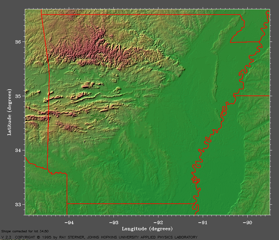
I have chased East into MO from Kansas and the terrain quickly turned hilly and wooded. I have spent time in Western Arkansas so I know the Forestlands of Western AR and Eastern OK are very nice but I would not chase them... But Eastern AR... when I look at google maps I see a fairly broad stretch , both East-West and North-South along the Mississippi that looks like farmland. I realize that I do not really know that area. If I have driven it it must have been dark.

So the question is..
Is there a chaseable section there ? Looks like all the way from Memphis to Little Rock and Natchez to Paducah is cropland.

If that is chaseable terrain then I may give that area a try for this weekends setup and any future Mississippi setups.


Anyone from Memphis want to give a terrain report. A chaseability rating.

--
Tom
 
Yeah I have had good success chasing in the rice fields etc. of E.Arkansas. Just have to be very aware of flood prone areas (if you see depth guage sticks all of the sudden be very cautious) Watch out for rapid river rises and overflows. TURN AROUND ...DON"T DROWN (LOL) You could find yourself in a world of hurt if you hit a flooded road and one of those god-forsaken Arkansas HP monsters heads your way.
 
Noooooo.............don't chase eastern Arkansas......it's horrible. Trust me - you wouldn't like it.

April0206Wynne04.jpg

April 2nd, 2006: About 2 miles WNW of Wynne, AR.

:cool:

Although I'm afraid that February 24th, 2007 is in no way shaping up to be another April 2nd, 2006......and not least w/r/t where the action will be happening.

KL
 
The "Yazoo Basin" is a relatively expansive area of flat, beautifully chaseable terrain. It runs roughly from Tunica to Yazoo City MS, westward to the MS river. I'm not as familiar with the area west of the river there, but looking at my Delorme's, looks pretty flat for a couple of counties into Arkansas.

The gotcha's are:
1) As usual, figure out your river crossing points in advance. They are few and far between there.
2) The area to the east of the basin gets hilly quickly. Several times, I have been on storms that looked beautiful in the basin, only to end up dodging an ugly, accelerating beast in the hills after sunset.

TonyC
 
The delta and prarie regions of eastern Arkansas, northwest Mississippi, extreme southeast Missouri and extreme northeast Louisiana are relatively flat, treeless and have a good road network. This is good for chasing.

Topography map:
ar.gif

forest_dens.gif
forest density

On the negative side, this region has a lower tornado and significant (2+ inch) hail frequency than "Chase Alley" (Great Plains). These two parameters are likely good indicators of supercell chase potential.

alltor.jpg

sighail.jpg


You can see the remainder of the SPC online severe weather climatology here http://www.spc.noaa.gov/climo/online/grids/index.html
and http://www.spc.noaa.gov/climo/online/rda/index.html

This region has many other problems. Storms are frequently obscured by low clouds, fog, haze, and smoke. Mesoscale convective systems (e.g., squall lines) are much more likely than the isolated supercells which are common on the high plains. Plus, when supercells do occur they tend to move faster than those which occur on the high plains later on during the spring. They typically enter and exit this region within 1-3 hours.

I'd likely chase this region if I lived in or near the area. However, I wouldn't if I didn't. I don't, so I won't. :)
 
I've chased the area once, and was going to mention that the storm speeds might be an issue this Saturday, figuring that they could move through this area fairly quickly leaving you with a one point intercept instead of a chase.
However, the forecasted storm motion actually parallels the long axis of this plain, which would give you much more time in to pursue in good visibility.
 
Middle Tennessee, especially the Nashville Basin(Rutherford,Wilson,Davidson,Sumner, and Williamson counties have relatively ok chase terrain. My hometown sits in a valley, that is fairly flat and the road network is ok, but with so much construction, its not that safe, but I've much success in the Basin, so it is worth a shot.
 
It is looking like any chasers that dare AR along with us are going to have to rely on something initiating in the extreme southeastern part of the state. If we chase at all - given the southwards shift of the models recently - this is where we will be come Saturday. That is about the only place that 60Tds still have a chance at sneaking up into. This is fine until you have to make a river crossing with those northeastwards-rocketing storms......at which point it is time to go find a burger shop. :cool:

Thanks to Bobby for posting the good graphics - those topo maps are always interesting to look at and it seems to me like at least one of AR surfaces on at least one thread every February ROFL. February should be affectionately renamed "River Crossing Month".

KL
 
This is fine until you have to make a river crossing with those northeastwards-rocketing storms......at which point it is time to go find a burger shop. :cool:
KL

Heh, heh...agreed...not too many places to cross the Mississippi, especially south of Helena, until you're practically in Louisiana.
 
Back
Top