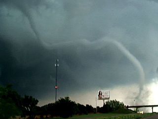
Central Oklahoma Tornadoes

Joined
Jun 30, 2004
Messages
330
Location
Leadville, CO/ Norman, OK
This summer I spent ten weeks at the National Weather Service in Norman doing a research project and thought I would share some of the results here. The title of the project was An 11-Year Radar Based Study of Tornadic Thunderstorms Over Central Oklahoma and some of the major points are included below. More information can also be found on my website.


  • 126 tornadoes were looked at between 2000 and 2010 that were within 60 miles of KTLX.
    • 104 tornadoes were produced by a supercell, 19 were produced by a QLCS, and 3 formed in a tropical environment (with the remnants of Erin).
  • Radar characteristics were measured and a storm mode (i.e. supercell, QLCS, or tropical) was determined, using GR2Analyst, at the time of the initial tornado touchdown which served as a proxy for the mature stage of each thunderstorm.
    • Radar characteristics include: storm width, storm height, low-level rotational velocity, mid level rotational velocity, mesocyclone width and height, and storm top divergence.


  • Substantial differences did exist between the radar characteristics of supercells and QLCSs.
    • This was especially obvious in mid level rotational velocity which was of all measured radar characteristics most correlated to tornado duration and F/EF rating.
    • This was reflected by the fact that most QLCS tornadoes were weaker and briefer than most of the supercellular tornadoes.
  • There were no strong correlations between any of the radar characteristics and Tornado-Warning lead time.
    • This is likely due to the numerous variables present during the tornado warning process.
  • There was a stronger correlation between storm mode and lead time likely due to the fact that sixty eight percent of the QLCS tornadoes were unwarned in this data set and lead time therefore set to "0 minutes."

  • Injuries were not strongly correlated to lead time.
    • Lead time should continue to be improved, but it is possible that researching other factors such as how the warnings are distributed to the public, call to action statements, and building construction standards would lower the number of injuries and deaths across the country.
  • The data set provided a spectrum of radar characteristics for supercells.
    • The spectrum was primarily linear and continuous suggesting that a distinct and separate storm category of "mini supercell" may not be able to be defined by using radar characteristics.

There were also two especially interesting cases that I came across on 5/10/10.
mw4jut.jpg

There is a tornado on the ground at the red circle, but there is essentially no storm present in reflectivity at any elevation scan. I do hesitate to call this a landspout, however, as the tornado was moving at 70mph. This is from Kingfisher, County.

2z4d6wy.jpg

This shows the Norman tornado and supercell, but there is another tornado located at the red circle. The tornado was on the ground for 20 minutes and was an EF2.

This is only a small amount of the information gathered during the 10 week project, but I hope some of it proves to be interesting!
 
Last edited by a moderator:
I'm really curious as to how those two tornadoes formed that you've outlined. Without seeing the full picture or later scans, I'm guessing that first one formed under some towering cumulus, before the storm could mature and put down any precipitation. The second one looks like it may have been under a flanking line tower. Could stretching of vorticity (spout) still be an explanation for these even with the storm speeds? Perhaps the area of vorticity was moving with the updraft, or the circulation became anchored to the updraft. There was also an incredible amount of helicity that day so I don't doubt those towers could have ingested enough of it to exhibit supercellular characteristics before they matured. You'd think some sort of RFD would show up on reflectivity if they were supercellular tornadoes, unless maybe the RFD had poor reflective qualities (dry).
 
Good day all,

A very similar scenario unfolded on May 24, 2011 near Shawnee, OK south of and along I-40.

Barely a "convective shower" on Radar ... But not so visually!

m12tor15.jpg


Below ... Truck that took a direct hit from the same tornado...

m12trk1.jpg
 
I think it showed up as barely a 'convective shower' on radar (although I disagree - I remember there being a pronounced hook & reflectivity) due to the proximity of the radar site to the storm (it was basically within 10 miles of the radar site)
 
This shows the Norman tornado and supercell, but there is another tornado located at the red circle. This is another tornado that does not appear to have a parent storm present in the reflectivity data. The tornado was on the ground for 20 minutes and was an EF2.
This tornado most certainly does have a parent storm, the same parent storm as the tornado just a few miles to its northwest in the picture. Remember, a storm isn't defined by the reflectivity signature - that only shows the precipitation. The storm is a combination of that and updraft/cloud, which the radar doesn't normally detect. Both of these tornadoes are under the same updraft, one is further down the flank and eventually moves in front of the other tornado.
 
Last edited by a moderator:
Two more brief comments:

126 tornadoes were looked at between 2000 and 2010 that were within 60 miles of KTLX.
Too bad you didn't extend the study one year on either end. 1999 was a banner year for tornadoes in OUN's area, and 2011 is shaping up to be that way as well.

There was a stronger correlation between storm mode and lead time likely due to the fact that sixty eight percent of the QLCS tornadoes were unwarned in this data set and lead time therefore set to "0 minutes."
Giving unwarned tornadoes a 0-minute lead time is really tainting your statistics, since 0-minutes is actually not too bad, if you consider points downstream from the tornado touchdown point have positive lead time. Since this is not the case, unwarned tornadoes should not be included when determining the average lead time.
 
This tornado most certainly does have a parent storm, the same parent storm as the tornado just a few miles to its northwest in the picture. Remember, a storm isn't defined by the reflectivity signature - that only shows the precipitation. The storm is a combination of that and updraft/cloud, which the radar doesn't normally detect. Both of these tornadoes are under the same updraft, one is further down the flank and eventually moves in front of the other tornado.

I would imagine this would be much more visual in the velocity data, where precipitation wouldnt neccesarily be required, but the boundaries from the parent storm over the area of the tornado's occurance would be evident.

Chip
 
Could stretching of vorticity (spout) still be an explanation for these even with the storm speeds? Perhaps the area of vorticity was moving with the updraft, or the circulation became anchored to the updraft. There was also an incredible amount of helicity that day so I don't doubt those towers could have ingested enough of it to exhibit supercellular characteristics before they matured. You'd think some sort of RFD would show up on reflectivity if they were supercellular tornadoes, unless maybe the RFD had poor reflective qualities (dry)
Skip, that is a good question. While out of the scope of this study, I did talk to my mentors about this case. We discussed that perhaps the tornadoes formed very quickly on this day before the supercells matured in the radar presentations. Essentially, the tornado and supercell formed simultaneously in that case before the supercell appeared to be fully organized on radar. This is not based on any research, just the product of one discussion.


This tornado most certainly does have a parent storm, the same parent storm as the tornado just a few miles to its northwest in the picture. Remember, a storm isn't defined by the reflectivity signature - that only shows the precipitation.
That is a very good point, Greg and I have changed that in the original post. That was definitely worded poorly. I simply wanted to bring attention to that being a fairly odd case.


Too bad you didn't extend the study one year on either end. 1999 was a banner year for tornadoes in OUN's area, and 2011 is shaping up to be that way as well.
I did not include 1999 due to the fact that 40 tornadoes occurred during the May 3 outbreak alone which would have accounted for 25.4 percent of the entire data set. I did not want one day to account for such a large portion of the data set. I would have liked to include 2011, but all of the necessary data were not available at the time.


Giving unwarned tornadoes a 0-minute lead time is really tainting your statistics, since 0-minutes is actually not too bad, if you consider points downstream from the tornado touchdown point have positive lead time. Since this is not the case, unwarned tornadoes should not be included when determining the average lead time
This is a very good point once again! I did this in order to separate tornadoes into two categories, "warned" and "unwarned" for the radar characteristic analysis portion of the study which was the primary focus of the study (I compared radar characteristics of storms that were warned and unwarned). It does skew the lead time results as the lead time for QLCSs would be 10 minutes (instead of 2 min) if all unwarned QLCS tornadoes were removed from the data set. Thanks for the input Greg!
 
Back
Top